Current Weather/Notams (Metars, TAFs, Notams, NWS Forecast, PIREPS, and nearby weather)
Customs Information Send updates to Support@FltPlan.com
Customs Not Available
Database effective 05/16/2024
Airport Diagram might not be current.
|
| Facility Name: | PARKER COUNTY |
| City Name: | WEATHERFORD |
| County: | PARKER |
| State abbrev: | TX |
| State Name: | TEXAS |
| | |
| Ownership: | PRIVATELY OWNED |
| Use: | OPEN TO THE PUBLIC |
| Owner's Name: | PARKER COUNTY AIRPORT HANGARS ASSOC |
| Address: | 4607 FOREST HILL CIRCLE |
| | FORT WORTH, TX 76140 |
| Owner's Phone: | 817-599-9210 |
| | |
| Manager's Name: | BRET PRIVITT |
| Address: | 4607 FOREST HILL CIRCLE |
| | FORT WORTH, TX 76140 |
| Phone: | (817) 822-7205 |
| | |
| FAA Region: | SOUTHWEST |
| FAA Field Office: | TEX |
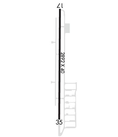
Runway Identifications
Runway Identification: 17/35Length: 2892 ft
Width: 40 ft
Surface: ASPHALT-GOOD CONDITION
Edge lights: Low IntensityTreatment: NONE
| | Runway: 17 | | Runway: 35 |
| Mag heading: | 175° | Mag heading: | 355° |
| Rwy Slope: | -.21% Down | Rwy Slope: | .21% Up |
| Approach: | | Approach: | |
| Pattern: | Left Traffic | Pattern: | Left Traffic |
| Markings: | BASIC | Markings: | BASIC |
| Marking Condition: | GOOD | Marking Condition: | GOOD |
| Arresting Dev: | | Arresting Dev: | |
| Lat & Long: | N3245.0 W09740.9 | Lat. & Long.: | N3244.5 W09740.9 |
| Elev: | 988.6 ft. MSL | Elev: | 982.6 ft. MSL |
| TCH: | | TCH: | |
| Visual Glide Path: | | Visual Glide Path: | |
| Displaced Threshold: | 220 feet | Displaced Threshold: | No |
| Touchdown Zone: | YES | Touchdown Zone: | YES |
| Touchdown Elev.: | 991.2 feet | Touchdown Elev.: | 991.2 feet |
| Visual Glide Slope: | | Visual Glide Slope: | |
| RVR Equipment: | | RVR Equipment: | |
| RVV Equipment: | NO | RVV Equipment: | NO |
| Approach Lights: | | Approach Lights: | |
| REIL: | NO | REIL: | NO |
| Centerline Lights: | NO | Centerline Lights: | NO |
| Touchdown lights: | NO | Touchdown lights: | NO |
| Runway Category: | Runway with a Visual Approach | Runway Category: | Runway with a Visual Approach |
| Declared Distances: | | Declared Distances: | |
| Obstructions: | TREE | Obstructions: | TREES |
| Marked: | NOT Marked/Lighted | Marked: | NOT Marked/Lighted |
| Clearance slope: | 8:1; APCH RATIO 18:1 AT DSPLCD THR. | Clearance slope: | 5:1; APCH SLOPE 20:1 AT DSPLCD THR. |
| Obstruction height: | 40 feet AGL | Obstruction height: | 40 feet AGL |
| Dist. from runway: | 526 feet | Dist. from runway: | 400 feet |
| Centerline offset: | 44 left of centerline | Centerline offset: | 125 feet right of centerline |
| Comments: | 5 FT FENCE 40 FT FM THR 120 FT R OF CNTRLN; 20 FT DROP-OFF 10 FT FROM THR 0B. | Comments: | |

