Current Weather/Notams (Metars, TAFs, Notams, NWS Forecast, PIREPS, and nearby weather)
Customs Information Send updates to Support@FltPlan.com
Customs Not Available
Database effective 05/16/2024
Airport Diagram might not be current.
|
| Facility Name: | BARROW COUNTY |
| City Name: | WINDER |
| County: | BARROW |
| State abbrev: | GA |
| State Name: | GEORGIA |
| | |
| Ownership: | PUBLICLY OWNED |
| Use: | OPEN TO THE PUBLIC |
| Owner's Name: | BARROW COUNTY ARPT AUTH. |
| Address: | 841 RONALD WOOD ROAD |
| | WINDER, GA 30680 |
| Owner's Phone: | 770-307-3013 |
| | |
| Manager's Name: | WANDA MITCHELL |
| Address: | 841 RONALD WOOD RD |
| | WINDER, GA 30680 |
| Phone: | 770-307-3013 |
| | |
| FAA Region: | SOUTHERN |
| FAA Field Office: | ATL |
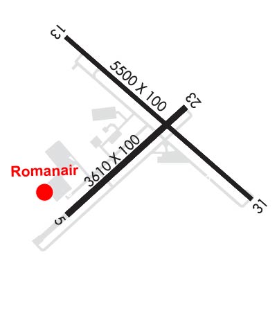
Runway Identifications
Runway Identification: 05/23Length: 3607 ft
Width: 100 ft
Surface: ASPHALT-GOOD CONDITION
Edge lights: Medium IntensityTreatment: NONE
| | Runway: 05 | | Runway: 23 |
| Mag heading: | 51° | Mag heading: | 231° |
| Rwy Slope: | -.50% Down | Rwy Slope: | .50% Up |
| Approach: | | Approach: | |
| Pattern: | Left Traffic | Pattern: | Left Traffic |
| Markings: | NONPRECISION INSTRUMENT | Markings: | NONPRECISION INSTRUMENT |
| Marking Condition: | FAIR | Marking Condition: | FAIR |
| Arresting Dev: | | Arresting Dev: | |
| Lat & Long: | N3358.7 W08340.4 | Lat. & Long.: | N3359.1 W08339.9 |
| Elev: | 934.3 ft. MSL | Elev: | 916.3 ft. MSL |
| TCH: | 22 ft. AGL | TCH: | 40 ft. AGL |
| Visual Glide Path: | 3.00 degrees | Visual Glide Path: | 3.00 degrees |
| Displaced Threshold: | No | Displaced Threshold: | No |
| Touchdown Zone: | YES | Touchdown Zone: | YES |
| Touchdown Elev.: | 934.3 feet | Touchdown Elev.: | 928.5 feet |
| Visual Glide Slope: | 2-Light PAPI on LEFT side of Runway | Visual Glide Slope: | 2-Light PAPI on LEFT side of Runway |
| RVR Equipment: | | RVR Equipment: | |
| RVV Equipment: | NO | RVV Equipment: | NO |
| Approach Lights: | | Approach Lights: | |
| REIL: | NO | REIL: | NO |
| Centerline Lights: | NO | Centerline Lights: | NO |
| Touchdown lights: | NO | Touchdown lights: | NO |
| Runway Category: | Runway with a Visual Approach | Runway Category: | Runway with a Non-precision Approach |
| Declared Distances: | | Declared Distances: | |
| Obstructions: | TREES | Obstructions: | TREES |
| Marked: | NOT Marked/Lighted | Marked: | NOT Marked/Lighted |
| Clearance slope: | 17:1 | Clearance slope: | 11:1 |
| Obstruction height: | 77 feet AGL | Obstruction height: | 38 feet AGL |
| Dist. from runway: | 1512 feet | Dist. from runway: | 642 feet |
| Centerline offset: | 160 left of centerline | Centerline offset: | 313 feet left of centerline |
| Comments: | | Comments: | |
Runway Identification: 13/31Length: 5202 ft
Width: 100 ft
Surface: ASPHALT-GOOD CONDITION
Edge lights: High IntensityTreatment: NONE
| | Runway: 13 | | Runway: 31 |
| Mag heading: | 134° | Mag heading: | 314° |
| Rwy Slope: | -.48% Down | Rwy Slope: | .48% Up |
| Approach: | | Approach: | ILS/DME |
| Pattern: | Left Traffic | Pattern: | Left Traffic |
| Markings: | NONPRECISION INSTRUMENT | Markings: | PRECISION INSTRUMENT |
| Marking Condition: | FAIR | Marking Condition: | FAIR |
| Arresting Dev: | | Arresting Dev: | |
| Lat & Long: | N3359.3 W08340.4 | Lat. & Long.: | N3358.8 W08339.6 |
| Elev: | 932.8 ft. MSL | Elev: | 907.7 ft. MSL |
| TCH: | 30 ft. AGL | TCH: | 45 ft. AGL |
| Visual Glide Path: | 3.00 degrees | Visual Glide Path: | 3.00 degrees |
| Displaced Threshold: | No | Displaced Threshold: | 602 feet |
| Touchdown Zone: | YES | Touchdown Zone: | YES |
| Touchdown Elev.: | 932.8 feet | Touchdown Elev.: | 921.9 feet |
| Visual Glide Slope: | 4-Light PAPI on LEFT side of Runway | Visual Glide Slope: | 4-Light PAPI on LEFT side of Runway |
| RVR Equipment: | | RVR Equipment: | |
| RVV Equipment: | NO | RVV Equipment: | NO |
| Approach Lights: | | Approach Lights: | MALSR - 1,400 foot medium intensity approach lighting system with runway alignment indicator lights |
| REIL: | NO | REIL: | NO |
| Centerline Lights: | NO | Centerline Lights: | NO |
| Touchdown lights: | NO | Touchdown lights: | NO |
| Runway Category: | Runway with a Non-precision Approach having visibility minimums greater than 3/4 mile | Runway Category: | Precision Instrument Runway |
| Declared Distances: | TORA:5202' TODA:5202' ASDA:5100' LDA:5100' | Declared Distances: | TORA:5202' TODA:5202' ASDA:5202' LDA:4600' |
| Obstructions: | POLE | Obstructions: | RR |
| Marked: | NOT Marked/Lighted | Marked: | NOT Marked/Lighted |
| Clearance slope: | 18:1; CONTROLLING OBSTRUCTION EXCEEDS A 45 DEGREE SLOPE | Clearance slope: | RWY 31 APCH RATIO 50:1 TO DSPLCD THR. |
| Obstruction height: | 27 feet AGL | Obstruction height: | 20 feet AGL |
| Dist. from runway: | 687 feet | Dist. from runway: | 201 feet |
| Centerline offset: | 366 left of centerline | Centerline offset: | 270 feet left of centerline |
| Comments: | | Comments: | RAILROAD BETWEEN 350-500 FT LEFT FROM 0-200 FT FROM RWY END. TREES 315 FT LEFT AT RWY END. |


