Current Weather/Notams (Metars, TAFs, Notams, NWS Forecast, PIREPS, and nearby weather)
Customs Information Send updates to Support@FltPlan.com
Customs Not Available
Database effective 04/18/2024
Airport Diagram might not be current.
|
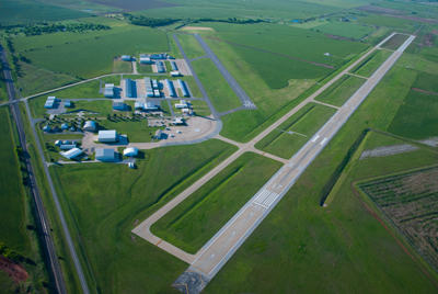
| Facility Name: | ENID WOODRING RGNL |
| City Name: | ENID |
| County: | GARFIELD |
| State abbrev: | OK |
| State Name: | OKLAHOMA |
| | |
| Ownership: | PUBLICLY OWNED |
| Use: | OPEN TO THE PUBLIC |
| Owner's Name: | CITY OF ENID |
| Address: | PO BOX 1768 |
| | ENID, OK 73702 |
| Owner's Phone: | 580-234-0400 |
| | |
| Manager's Name: | KESTON COOK |
| Address: | 1026 SOUTH 66TH STREET |
| | ENID, OK 73701 |
| Phone: | 580-616-7386 |
| | |
| FAA Region: | SOUTHWEST |
| FAA Field Office: | AOK |
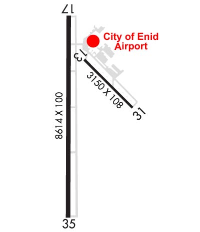
Runway Identifications
Runway Identification: 13/31Length: 3150 ft
Width: 108 ft
Surface: ASPHALT-POOR CONDITION
Edge lights: Medium IntensityTreatment: NONE
| | Runway: 13 | | Runway: 31 |
| Mag heading: | 130° | Mag heading: | 310° |
| Rwy Slope: | -.04% Down | Rwy Slope: | .04% Up |
| Approach: | | Approach: | |
| Pattern: | Left Traffic | Pattern: | Right Traffic |
| Markings: | BASIC | Markings: | BASIC |
| Marking Condition: | GOOD | Marking Condition: | GOOD |
| Arresting Dev: | | Arresting Dev: | |
| Lat & Long: | N3622.9 W09747.3 | Lat. & Long.: | N3622.5 W09746.9 |
| Elev: | 1158.7 ft. MSL | Elev: | 1157.4 ft. MSL |
| TCH: | | TCH: | |
| Visual Glide Path: | | Visual Glide Path: | |
| Displaced Threshold: | 112 feet | Displaced Threshold: | No |
| Touchdown Zone: | YES | Touchdown Zone: | YES |
| Touchdown Elev.: | 1158.7 feet | Touchdown Elev.: | 1158.7 feet |
| Visual Glide Slope: | | Visual Glide Slope: | |
| RVR Equipment: | | RVR Equipment: | |
| RVV Equipment: | NO | RVV Equipment: | NO |
| Approach Lights: | | Approach Lights: | |
| REIL: | NO | REIL: | NO |
| Centerline Lights: | NO | Centerline Lights: | NO |
| Touchdown lights: | NO | Touchdown lights: | NO |
| Runway Category: | Runway with a Visual Approach | Runway Category: | Runway with a Visual Approach |
| Declared Distances: | | Declared Distances: | |
Runway Identification: 17/35Length: 8613 ft
Width: 100 ft
Surface: CONCRETE-GOOD CONDITION
Edge lights: Medium IntensityTreatment: GROOVED
Weight: PCN 21 /R/C/W/T
| | Runway: 17 | | Runway: 35 |
| Mag heading: | 175° | Mag heading: | 355° |
| Rwy Slope: | -.35% Down | Rwy Slope: | .35% Up |
| Approach: | | Approach: | ILS |
| Pattern: | Left Traffic | Pattern: | Right Traffic |
| Markings: | PRECISION INSTRUMENT | Markings: | PRECISION INSTRUMENT |
| Marking Condition: | GOOD | Marking Condition: | GOOD |
| Arresting Dev: | | Arresting Dev: | |
| Lat & Long: | N3623.2 W09747.5 | Lat. & Long.: | N3621.8 W09747.5 |
| Elev: | 1167.2 ft. MSL | Elev: | 1137.3 ft. MSL |
| TCH: | 52 ft. AGL | TCH: | 49 ft. AGL |
| Visual Glide Path: | 3.00 degrees | Visual Glide Path: | 3.00 degrees |
| Displaced Threshold: | 611 feet | Displaced Threshold: | No |
| Touchdown Zone: | YES | Touchdown Zone: | YES |
| Touchdown Elev.: | 1164.6 feet | Touchdown Elev.: | 1147.2 feet |
| Visual Glide Slope: | 4-Light PAPI on LEFT side of Runway | Visual Glide Slope: | 4-Light PAPI on LEFT side of Runway |
| RVR Equipment: | | RVR Equipment: | |
| RVV Equipment: | NO | RVV Equipment: | NO |
| Approach Lights: | | Approach Lights: | MALSR - 1,400 foot medium intensity approach lighting system with runway alignment indicator lights |
| REIL: | YES | REIL: | NO |
| Centerline Lights: | NO | Centerline Lights: | NO |
| Touchdown lights: | NO | Touchdown lights: | NO |
| Runway Category: | D | Runway Category: | Precision Instrument Runway |
| Declared Distances: | | Declared Distances: | |
| Obstructions: | ROAD | Obstructions: | |
| Marked: | NOT Marked/Lighted | Marked: | |
| Clearance slope: | 4:1 | Clearance slope: | 50:1 |
| Obstruction height: | 20 feet AGL | Obstruction height: | |
| Dist. from runway: | 284 feet | Dist. from runway: | |
| Centerline offset: | 512 left of centerline | Centerline offset: | |
| Comments: | | Comments: | |