Current Weather/Notams (Metars, TAFs, Notams, NWS Forecast, PIREPS, and nearby weather)
Customs Information Send updates to Support@FltPlan.com
Customs Not Available
Database effective 04/18/2024
Airport Diagram might not be current.
|
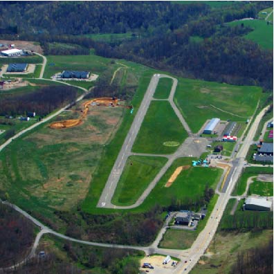
| Facility Name: | GREENE COUNTY |
| City Name: | WAYNESBURG |
| County: | GREENE |
| State abbrev: | PA |
| State Name: | PENNSYLVANIA |
| | |
| Ownership: | PUBLICLY OWNED |
| Use: | OPEN TO THE PUBLIC |
| Owner's Name: | GREENE COUNTY |
| Address: | COUNTY OFFICE BLDG |
| | WAYNESBURG, PA 15370 |
| Owner's Phone: | 724-852-5323 |
| | |
| Manager's Name: | MARIO BARCHIESI |
| Address: | 107 FAIRGROUNDS RD |
| | WAYNESBURG, PA 15370 |
| Phone: | 724-998-5042 |
| | |
| FAA Region: | EASTERN |
| FAA Field Office: | HAR |
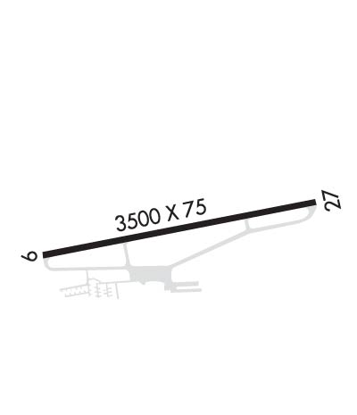
Runway Identifications
Runway Identification: 09/27Length: 3500 ft
Width: 75 ft
Surface: ASPHALT-FAIR CONDITION
Edge lights: Treatment: NONE
| | Runway: 09 | | Runway: 27 |
| Mag heading: | N/A | Mag heading: | N/A |
| Rwy Slope: | -.08% Down | Rwy Slope: | .08% Up |
| Approach: | | Approach: | |
| Pattern: | Left Traffic | Pattern: | Left Traffic |
| Markings: | BASIC | Markings: | BASIC |
| Marking Condition: | POOR; RWY NRS AND CL MRKGS IN POOR COND. | Marking Condition: | POOR; RWY NRS AND CL MRKGS IN POOR COND. |
| Arresting Dev: | | Arresting Dev: | |
| Lat & Long: | N3954.0 W08008.2 | Lat. & Long.: | N3954.1 W08007.5 |
| Elev: | 1064.9 ft. MSL | Elev: | 1062.1 ft. MSL |
| TCH: | | TCH: | |
| Visual Glide Path: | | Visual Glide Path: | |
| Displaced Threshold: | No | Displaced Threshold: | No |
| Touchdown Zone: | YES | Touchdown Zone: | YES |
| Touchdown Elev.: | 1068.6 feet | Touchdown Elev.: | 1068.6 feet |
| Visual Glide Slope: | | Visual Glide Slope: | |
| RVR Equipment: | | RVR Equipment: | |
| RVV Equipment: | NO | RVV Equipment: | NO |
| Approach Lights: | | Approach Lights: | |
| REIL: | NO | REIL: | NO |
| Centerline Lights: | NO | Centerline Lights: | NO |
| Touchdown lights: | NO | Touchdown lights: | NO |
| Runway Category: | Runway with a Non-precision Approach | Runway Category: | Runway with a Non-precision Approach |
| Declared Distances: | | Declared Distances: | |
| Obstructions: | TREES | Obstructions: | TREES |
| Marked: | NOT Marked/Lighted | Marked: | NOT Marked/Lighted |
| Clearance slope: | 4:1 | Clearance slope: | 3:1 |
| Obstruction height: | 14 feet AGL | Obstruction height: | 25 feet AGL |
| Dist. from runway: | 257 feet | Dist. from runway: | 285 feet |
| Centerline offset: | 116 left of centerline | Centerline offset: | 84 feet right of centerline |
| Comments: | 15 FT TREES, 128 FT FM RWY END, 166 FT R; 16 FT TREES, 95 FT FM RWY END 180 FT L. | Comments: | |