Click here for more info on on SMS!

KWAL

WALLOPS FLIGHT FACILITY
WALLOPS ISLAND
VA
Time Zone: Eastern
Lat: N 3756.4
Long: W 07528.0
Elev: 40
Var: +11
Longest Runway: 8748
Clr Del: 121.7
AWOS: 119.17
Ground: 127.87
Tower: 126.5

FBO & Flight Services info for KWAL

FBOs: Update your Fuel Prices

ASOSPh: 757-824-0820
-
Freq: 119.17  
If you are an FBO, call 1-203-262-1700 to update your info or email: FltPlan.Advertising@garmin.com
Advertise your FBO on FltPlan.com

Runway & Approach Info for KWAL
Rwy
Length
Land Dist**
Approach*
  Rwy
Length
Land Dist**
Approach*
04
8748x150  8748'          
 
  
22
  8748x150  8748'          
 
10
8005x200  8005'          
 
  
28
  8005x200  8005'          
 
17
4808x150  4808'          
 
  
35
  4808x150  4808'          
 
 * only ILS, LOC, LDA, and SDF approaches to a specific runway are shown
** For any Declared Landing Distance Available, please see A/FD or Approach plates
Runway Weight Capability (lbs.) Help
Runway IDSingle WheelDouble WheelDouble Tandem WheelDual Double Wheel
04/2257,000115,000225,000N/A
10/2857,000115,000225,000N/A
17/3515,00040,00075,000N/A
These numbers are Advisory and are not limits.   The Airport Manager should have more accurate Weight Limits
Approach Charts
Approaches    
Current Weather/Notams
Customs Information Send updates to Support@FltPlan.com
Customs Not Available
Database effective 04/18/2024
Airport Diagram of KWAL
Airport Diagram might not be current.

Facility Name: WALLOPS FLIGHT FACILITY
City Name: WALLOPS ISLAND
County: ACCOMACK
State abbrev: VA
State Name: VIRGINIA
   
Ownership: PUBLICLY OWNED
Use: PRIVATE
Owner's Name: NASA
Address: WALLOPS FLIGHT FACILITY
 WALLOPS ISLAND, VA 23337
Owner's Phone: 757-824-1240
  
Manager's Name: ED SUDENDORF
Address: WALLOPS FLIGHT FACILITY
 WALLOPS ISLAND, VA 23337
Phone: 757-824-1250
   
FAA Region: EASTERN
FAA Field Office: DCA


Sunrise / Sunset times for WALLOPS FLIGHT FACILITY

DateSunriseSunset
04/18/24 Thursday6:2119:41
04/19/24 Friday6:2019:42
04/20/24 Saturday6:1919:43
04/21/24 Sunday6:1719:44
04/22/24 Monday6:1619:45
04/23/24 Tuesday6:1519:46
04/24/24 Wednesday6:1319:47
04/25/24 Thursday6:1219:48
04/26/24 Friday6:1119:49
04/27/24 Saturday6:1019:50
04/28/24 Sunday6:0919:51
04/29/24 Monday6:0719:51
04/30/24 Tuesday6:0619:52
05/01/24 Wednesday6:0519:53

Airport Facilities

Airport Attendance ScheduleCONTINUOUS
Airport Status OPERATIONAL (This Status can change at any time - please check NOTAMS)
Airport Lighting ScheduleFOR ROTG BCN CALL CTAF.
Airport Storage AvailableNONE
Extra Services AvailableNONE
Wind IndicatorYES - (lighted)
Control TowerYES
CTAF Frequency126.500; UHF CTAF - 306.975.
Unicom Frequency
Rotating Beacon ColorWG
Segmented CircleNO
Landing FeeNO

Airport Inspection Data

Airport Inspected5010-2 PRIVATE USE MAILOUT PROGRAM - performed by the OWNER
Inspection DateUnknown

Airport Services

Type of Fuel AvailableJET A (freeze point -40C)
Airframe Repair ServiceNONE
Power Plant Repair ServiceNONE

Geographic Data

LatitudeN3756.4
LongitudeW07528.0 (ESTIMATED)
Arpt Elevation40ft (SURVEYED)
Magnetic Variation11W
5 miles Sof WALLOPS ISLAND
Traffic Pattern Altitude
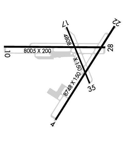
Sectional ChartWASHINGTON

Aircraft Data

Operations (Reported)YearlyAvg. Daily
General Aviation Transient 00
General Aviation Local 00
Air Taxi 00
Commerical 00
Commuter 00
Military 00
Aircraft based on Field
General Aviation Singles 0
General Aviation Multi 8
Jet Aircraft 2
General Aviation Helicopters 1
Military Aircraft 0
Gliders 0
Ultralights 0

FAA Services

FSS on field NO
FSS tie-in LEESBURG
FSS Phone 1-800-WX-BRIEF
Who issues Notams WAL
Notam D service at airport YES
ARTCC Name WASHINGTON

Federal Status

Airport Certification
Aircraft Rescue & Firefighting IndexNone
Airport of EntryNo
Custom Landing RightsNo
Joint Civil/MilitaryNo
Military Landing rightsNo

Remarks

EXTENSIVE RESEARCH TEST DEVELOPMENT IN PROGRESS.
MILITARY TURBOPROP TRAINING DAILY UNTIL 2300L.
FCLP EQUIPMENT DIRECTLY ADJACENT TO LEFT SIDE OF RWY 10 1335-1725 FT FM APPROACH END. FCLP EQUIPMENT DIRECTLY ADJACENT TO LEFT SIDE OF RWY 28 1340-1725 FT FM APPROACH END.
TOUCH AND GO LDGS NA WHEN ATCT CLSD.
RWY 17/35 CLSD WHEN ATCT CLSD.
WHEN ATCT CLSD, 126.5 CTAF ONLY. EXPC NO RESP OR ADZY SVCS.
E-28 ARRESTING GEAR 1500 FT FM THE NORTH END OF RWY 22 IS RIGGED/IN BATTERY.
PPR 24 HR PN TO LDG, PHONE 757-824-1688.
FOR CD CTC PATUXENT APCH AT 301-342-3740, WHEN PATUXENT APCH IS CLSD CTC POTOMAC APCH AT 866-640-4124.
DEER & BIRDS ON AND INVOF ARPT.
NUMEROUS RADAR FACILITIES AT ARPT WITH POSSIBLE RADIO FREQUENCY HAZARD TO ORDNANCE.
Airport Communications & Frequencies:
WALLOPS Tower Frequencies:   Hours(local) of operation: OPR 1300-2200Z++ MON-FRI EXC FEDERAL HOL AND BY NOTAM.   
126.5
306.975
WALLOPS Ground Frequencies:
127.875
269.325
Clearance Delivery Frequencies:
121.7
CTAF Frequency:
126.500; UHF CTAF - 306.975.
Remarks
  • APCH/DEP SVC PRVDD BY POTOMAC TRACON 127.2/281.47 (0400-1200Z MON-FRI, 2300-1300Z SAT-SUN. OTHER TIMES BY NOTAM.) WHEN PATUXENT APCH CTL CLSD.
  • PATUXENT Primary Approach Frequencies:  
    127.95
    314.0
    POTOMAC Part-time Approach Frequencies:  
    127.2 WHEN NHK APCH CLSD
    281.475 WHEN NHK APCH CLSD
    PATUXENT Primary Departure Frequencies:  
    127.95
    314.0
    POTOMAC Part-time Departure Frequencies:  
    127.2 WHEN NHK APCH CLSD
    281.475 WHEN NHK APCH CLSD
    Runway Identifications
    Runway Identification: 04/22
    Length: 8748 ft
    Width: 150 ft
    Surface: CONCRETE ASPHALT-GOOD CONDITION
    Edge lights: High Intensity

    Treatment: NONE

     Runway: 04   Runway: 22
    Mag heading: 43°Mag heading: 223°
    Rwy Slope: -.03% DownRwy Slope: .03% Up
    Approach: Approach:
    Pattern: Left TrafficPattern: Left Traffic
    Markings: NONPRECISION INSTRUMENTMarkings: NONPRECISION INSTRUMENT
    Marking Condition: GOODMarking Condition: GOOD
    Arresting Dev: Arresting Dev: E28; HOOK E28(B) (1500 FT).
    Lat & Long: N3755.6  W07528.3Lat. & Long.: N3756.8  W07527.3
    Elev: 34.0 ft. MSLElev: 31.3 ft. MSL
    TCH: 57 ft. AGLTCH: 60 ft. AGL
    Visual Glide Path: 3.00 degreesVisual Glide Path: 3.00 degrees
    Displaced Threshold: NoDisplaced Threshold: No
    Touchdown Zone: YESTouchdown Zone: YES
    Touchdown Elev.: 36.7 feetTouchdown Elev.: 36.0 feet
    Visual Glide Slope: 4-Light PAPI on LEFT side of RunwayVisual Glide Slope: 4-Light PAPI on LEFT side of Runway
    RVR Equipment: RVR Equipment:
    RVV Equipment: NORVV Equipment: NO
    Approach Lights: Approach Lights:
    REIL: YESREIL: YES
    Centerline Lights: NOCenterline Lights: NO
    Touchdown lights: NOTouchdown lights: NO
    Runway Category: Runway with a Non-precision Approach having visibility minimums greater than 3/4 mileRunway Category: Runway with a Non-precision Approach having visibility minimums greater than 3/4 mile
    Declared Distances: Declared Distances:
    Obstructions: Obstructions: 166 FT HIGH RADAR DISH 800 FT R OF APCH 22.
    Marked: Marked: NOT Marked/Lighted
    Clearance slope: Clearance slope:
    Obstruction height: Obstruction height:
    Dist. from runway: Dist. from runway:
    Centerline offset: Centerline offset:
    Comments: Comments:
    Runway Identification: 10/28
    Length: 8005 ft
    Width: 200 ft
    Surface: CONCRETE ASPHALT-GOOD CONDITION
    Edge lights: High Intensity

    Treatment: NONE

     Runway: 10   Runway: 28
    Mag heading: 101°Mag heading: 281°
    Rwy Slope: .20% UpRwy Slope: -.20% Down
    Approach: Approach:
    Pattern: Left TrafficPattern: Left Traffic
    Markings: NONPRECISION INSTRUMENTMarkings: NONPRECISION INSTRUMENT
    Marking Condition: GOODMarking Condition: GOOD
    Arresting Dev: Arresting Dev:
    Lat & Long: N3756.6  W07529.1Lat. & Long.: N3756.6  W07527.4
    Elev: 19.4 ft. MSLElev: 35.2 ft. MSL
    TCH: 69 ft. AGLTCH: 61 ft. AGL
    Visual Glide Path: 3.00 degreesVisual Glide Path: 3.00 degrees
    Displaced Threshold: NoDisplaced Threshold: No
    Touchdown Zone: YESTouchdown Zone: YES
    Touchdown Elev.: 37.9 feetTouchdown Elev.: 40.2 feet
    Visual Glide Slope: 4-Light PAPI on LEFT side of RunwayVisual Glide Slope: 4-Light PAPI on LEFT side of Runway
    RVR Equipment: RVR Equipment:
    RVV Equipment: NORVV Equipment: NO
    Approach Lights: Approach Lights:
    REIL: YESREIL: YES
    Centerline Lights: NOCenterline Lights: NO
    Touchdown lights: NOTouchdown lights: NO
    Runway Category: Runway with a Non-precision Approach having visibility minimums greater than 3/4 mileRunway Category: Runway with a Non-precision Approach having visibility minimums greater than 3/4 mile
    Declared Distances: Declared Distances:
    Obstructions: Obstructions: 510 FT CATV TWR 4 MI OFF APCH RWY 28.
    Marked: Marked: NOT Marked/Lighted
    Clearance slope: Clearance slope:
    Obstruction height: Obstruction height:
    Dist. from runway: Dist. from runway:
    Centerline offset: Centerline offset:
    Comments: Comments:
    Runway Identification: 17/35
    Length: 4808 ft
    Width: 150 ft
    Surface: ASPHALT-GOOD CONDITION
    Edge lights: High Intensity

    Treatment: NONE

     Runway: 17   Runway: 35
    Mag heading: 169°Mag heading: 349°
    Rwy Slope: .08% UpRwy Slope: -.08% Down
    Approach: Approach:
    Pattern: Left TrafficPattern: Left Traffic
    Markings: NONPRECISION INSTRUMENTMarkings: NONPRECISION INSTRUMENT
    Marking Condition: FAIRMarking Condition: FAIR
    Arresting Dev: Arresting Dev:
    Lat & Long: N3756.8  W07528.1Lat. & Long.: N3756.1  W07527.7
    Elev: 30.7 ft. MSLElev: 34.6 ft. MSL
    TCH: 63 ft. AGLTCH: 59 ft. AGL
    Visual Glide Path: 3.00 degreesVisual Glide Path: 3.00 degrees
    Displaced Threshold: NoDisplaced Threshold: No
    Touchdown Zone: YESTouchdown Zone: YES
    Touchdown Elev.: 39.2 feetTouchdown Elev.: 39.1 feet
    Visual Glide Slope: 4-Light PAPI on LEFT side of RunwayVisual Glide Slope: 4-Light PAPI on LEFT side of Runway
    RVR Equipment: RVR Equipment:
    RVV Equipment: NORVV Equipment: NO
    Approach Lights: Approach Lights:
    REIL: YESREIL: YES
    Centerline Lights: NOCenterline Lights: NO
    Touchdown lights: NOTouchdown lights: NO
    Runway Category: Runway with a Non-precision Approach having visibility minimums greater than 3/4 mileRunway Category: Runway with a Non-precision Approach having visibility minimums greater than 3/4 mile
    Declared Distances: Declared Distances:
    C:/P: