Current Weather/Notams (Metars, TAFs, Notams, NWS Forecast, PIREPS, and nearby weather)
Customs Information Send updates to Support@FltPlan.com
Customs Not Available
Database effective 05/16/2024
Airport Diagram might not be current.
|
| Facility Name: | GRANT COUNTY |
| City Name: | PETERSBURG |
| County: | GRANT |
| State abbrev: | WV |
| State Name: | WEST VIRGINIA |
| | |
| Ownership: | PUBLICLY OWNED |
| Use: | OPEN TO THE PUBLIC |
| Owner's Name: | GRANT COUNTY AIRPORT AUTH |
| Address: | 5 HIGHLAND AVE |
| | PETERSBURG, WV 26847 |
| Owner's Phone: | 304-257-4435 |
| | |
| Manager's Name: | TOM FEASTER |
| Address: | 440 AIRPORT RD |
| | PETERSBURG, WV 26802 |
| Phone: | 304-257-4435 |
| | |
| FAA Region: | EASTERN |
| FAA Field Office: | BKW |
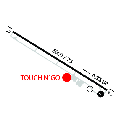
Runway Identifications
Runway Identification: 13/31Length: 5000 ft
Width: 75 ft
Surface: ASPHALT-GOOD CONDITION
Edge lights: Medium IntensityTreatment: NONE
| | Runway: 13 | | Runway: 31 |
| Mag heading: | 130° | Mag heading: | 310° |
| Rwy Slope: | -.30% Down | Rwy Slope: | .30% Up |
| Approach: | | Approach: | LDA/DME |
| Pattern: | Left Traffic | Pattern: | Right Traffic; RIGHT TRAFFIC FOR GLIDER AND ULTRA-LIGHT ONLY. ALL OTHER POWERED AIRCRAFT STANDARD LEFT TRAFFIC PATTERN. |
| Markings: | BASIC | Markings: | NONPRECISION INSTRUMENT |
| Marking Condition: | FAIR | Marking Condition: | FAIR |
| Arresting Dev: | | Arresting Dev: | |
| Lat & Long: | N3859.9 W07909.2 | Lat. & Long.: | N3859.5 W07908.3 |
| Elev: | 962.9 ft. MSL | Elev: | 947.8 ft. MSL |
| TCH: | | TCH: | 46 ft. AGL |
| Visual Glide Path: | | Visual Glide Path: | 6.50 degrees |
| Displaced Threshold: | No | Displaced Threshold: | No |
| Touchdown Zone: | YES | Touchdown Zone: | YES |
| Touchdown Elev.: | 962.9 feet | Touchdown Elev.: | 956.6 feet |
| Visual Glide Slope: | | Visual Glide Slope: | 4-Light PAPI on LEFT side of Runway |
| RVR Equipment: | | RVR Equipment: | |
| RVV Equipment: | NO | RVV Equipment: | NO |
| Approach Lights: | | Approach Lights: | |
| REIL: | YES | REIL: | YES |
| Centerline Lights: | NO | Centerline Lights: | NO |
| Touchdown lights: | NO | Touchdown lights: | NO |
| Runway Category: | Runway with a Visual Approach | Runway Category: | Runway with a Non-precision Approach having visibility minimums greater than 3/4 mile |
| Declared Distances: | | Declared Distances: | |
| Obstructions: | FENCE | Obstructions: | FENCE |
| Marked: | NOT Marked/Lighted | Marked: | NOT Marked/Lighted |
| Clearance slope: | | Clearance slope: | 17:1 |
| Obstruction height: | 6 feet AGL | Obstruction height: | 6 feet AGL |
| Dist. from runway: | 201 feet | Dist. from runway: | 305 feet |
| Centerline offset: | 250 left of centerline | Centerline offset: | 255 feet left of centerline |
| Comments: | | Comments: | |