Current Weather/Notams (Metars, TAFs, Notams, NWS Forecast, PIREPS, and nearby weather)
Customs Information Send updates to Support@FltPlan.com
Customs Not Available
Database effective 05/16/2024
Airport Diagram might not be current.
|
| Facility Name: | NEW KENT COUNTY |
| City Name: | QUINTON |
| County: | NEW KENT |
| State abbrev: | VA |
| State Name: | VIRGINIA |
| | |
| Ownership: | PUBLICLY OWNED |
| Use: | OPEN TO THE PUBLIC |
| Owner's Name: | COUNTY OF NEW KENT |
| Address: | P. O. BOX 150, 12007 COURT HOUSE CIRCLE |
| | NEW KENT, VA 23124 |
| Owner's Phone: | 804-966-9683 |
| | |
| Manager's Name: | DUANE GOSS |
| Address: | 6901 TERMINAL RD |
| | QUINTON, VA 23141-2427 |
| Phone: | 804-932-3984 |
| | |
| FAA Region: | EASTERN |
| FAA Field Office: | DCA |
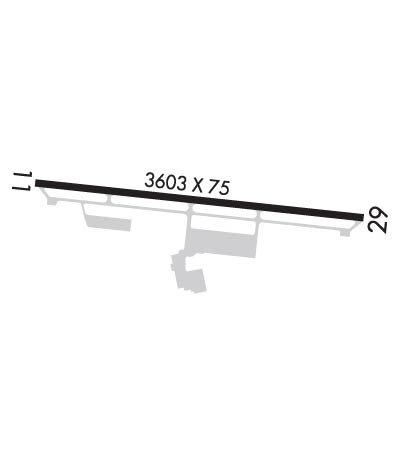
Runway Identifications
Runway Identification: 11/29Length: 3602 ft
Width: 75 ft
Surface: ASPHALT-GOOD CONDITION
Edge lights: Medium IntensityTreatment: NONE
| | Runway: 11 | | Runway: 29 |
| Mag heading: | 106° | Mag heading: | 286° |
| Rwy Slope: | -.37% Down | Rwy Slope: | .37% Up |
| Approach: | | Approach: | |
| Pattern: | Left Traffic | Pattern: | Left Traffic |
| Markings: | NONPRECISION INSTRUMENT | Markings: | NONPRECISION INSTRUMENT |
| Marking Condition: | FAIR | Marking Condition: | FAIR |
| Arresting Dev: | | Arresting Dev: | |
| Lat & Long: | N3730.2 W07708.0 | Lat. & Long.: | N3730.2 W07707.2 |
| Elev: | 120.7 ft. MSL | Elev: | 107.5 ft. MSL |
| TCH: | 45 ft. AGL | TCH: | 45 ft. AGL |
| Visual Glide Path: | 4.00 degrees | Visual Glide Path: | 4.00 degrees |
| Displaced Threshold: | No | Displaced Threshold: | No |
| Touchdown Zone: | YES | Touchdown Zone: | YES |
| Touchdown Elev.: | 120.7 feet | Touchdown Elev.: | 120.1 feet |
| Visual Glide Slope: | 2-Light PAPI on RIGHT side of Runway | Visual Glide Slope: | 2-Light PAPI on LEFT side of Runway |
| RVR Equipment: | | RVR Equipment: | |
| RVV Equipment: | NO | RVV Equipment: | NO |
| Approach Lights: | | Approach Lights: | |
| REIL: | YES | REIL: | YES |
| Centerline Lights: | NO | Centerline Lights: | NO |
| Touchdown lights: | NO | Touchdown lights: | NO |
| Runway Category: | Runway with a Non-precision Approach | Runway Category: | Runway with a Non-precision Approach |
| Declared Distances: | | Declared Distances: | |
| Obstructions: | ROAD | Obstructions: | TREES |
| Marked: | NOT Marked/Lighted | Marked: | NOT Marked/Lighted |
| Clearance slope: | 11:1 | Clearance slope: | 11:1 |
| Obstruction height: | 5 feet AGL | Obstruction height: | 20 feet AGL |
| Dist. from runway: | 258 feet | Dist. from runway: | 438 feet |
| Centerline offset: | 9B | Centerline offset: | 165 feet right of centerline |
| Comments: | RWY 11 - ROADWAY +15 FT 260 FT FM RWY END. | Comments: | 13 FT BRUSH, 101 FT RIGHT OF CTRLN ON APCH AT THLD. |

