Click here for more info on on SMS!

KW91

SMITH MOUNTAIN LAKE
MONETA
VA
Time Zone: Eastern
Lat: N 3706.5
Long: W 07935.5
Elev: 892
Var: +09
Longest Runway: 3058
CTAF: 122.97

FBO & Flight Services info for KW91

FBOs: Update your Fuel Prices
Providing high quality fuel and services to you and your customers from Phillips 66 Aviation.
Ph: 540-297-4859
-
Freq: 122.8Website-
Service
Jet
100LL
SAF
MoGas
Full        Last Update: 04/06/2024 13:59

Self  5.69    
Misc. Info: Address: 1090 CUTLASS RD   MONETA, VA 24121

If you are an FBO, call 1-203-262-1700 to update your info or email: FltPlan.Advertising@garmin.com
Advertise your FBO on FltPlan.com

Runway & Approach Info for KW91
Rwy
Length
Land Dist**
Approach*
  Rwy
Length
Land Dist**
Approach*
05
3058x50  2808'          
 
  
23
  3058x50  3058'          
 
 * only ILS, LOC, LDA, and SDF approaches to a specific runway are shown
** For any Declared Landing Distance Available, please see A/FD or Approach plates
Runway Weight Capability (lbs.) Help
Runway IDSingle WheelDouble WheelDouble Tandem WheelDual Double Wheel
05/23N/AN/AN/AN/A
These numbers are Advisory and are not limits.   The Airport Manager should have more accurate Weight Limits
Approach Charts
Approaches    
Current Weather/Notams
Customs Information Send updates to Support@FltPlan.com
Customs Not Available
Database effective 05/16/2024
Airport Diagram of KW91
Airport Diagram might not be current.

Facility Name: SMITH MOUNTAIN LAKE
City Name: MONETA
County: BEDFORD
State abbrev: VA
State Name: VIRGINIA
   
Ownership: PRIVATELY OWNED
Use: OPEN TO THE PUBLIC
Owner's Name: SMITH MOUNTAIN LAKE AIRPORT, LLC.
Address: 1090 CUTLASS RD
 MONETA, VA 24121
Owner's Phone: 540-297-4859
  
Manager's Name: MOE BAZAZAN
Address: 1090 CUTLASS RD
 MONETA, VA 24121
Phone: 540-297-4859
   
FAA Region: EASTERN
FAA Field Office: DCA


Sunrise / Sunset times for SMITH MOUNTAIN LAKE

DateSunriseSunset
04/25/24 Thursday6:3020:03
04/26/24 Friday6:2920:04
04/27/24 Saturday6:2820:05
04/28/24 Sunday6:2620:06
04/29/24 Monday6:2520:06
04/30/24 Tuesday6:2420:07
05/01/24 Wednesday6:2320:08
05/02/24 Thursday6:2220:09
05/03/24 Friday6:2120:10
05/04/24 Saturday6:2020:11
05/05/24 Sunday6:1920:12
05/06/24 Monday6:1820:13
05/07/24 Tuesday6:1720:14
05/08/24 Wednesday6:1620:14

Airport Facilities

Airport Attendance ScheduleCONTINUOUS
Airport Status OPERATIONAL (This Status can change at any time - please check NOTAMS)
Airport Lighting Schedule
Airport Storage AvailableTie Downs
Extra Services AvailableFlight Instruction, Aircraft Rental, Aircraft Sales
Wind IndicatorYES - (unlit)
Control TowerNO
CTAF Frequency122.975
Unicom Frequency122.975
Rotating Beacon ColorWG
Segmented CircleNO
Landing Fee

Airport Inspection Data

Airport InspectedSTATE - performed by STATE AERONAUTICAL PERSONNEL
Inspection Date08/24/2023

Airport Services

Type of Fuel AvailableGrade 100LL; -1024-HR SELF-SERVE FUEL AVAILABLE WITH CREDIT CARD.
Airframe Repair ServiceMAJOR
Power Plant Repair ServiceMAJOR

Geographic Data

LatitudeN3706.5
LongitudeW07935.5 (ESTIMATED)
Arpt Elevation892ft (SURVEYED)
Magnetic Variation09W
4 miles SEof MONETA
Traffic Pattern Altitude
Sectional ChartCINCINNATI

Aircraft Data

Operations (Reported)YearlyAvg. Daily
General Aviation Transient 4791
General Aviation Local 497114
Air Taxi 70
Commerical 00
Commuter 00
Military 30
Aircraft based on Field
General Aviation Singles 34
General Aviation Multi 3
Jet Aircraft 0
General Aviation Helicopters 0
Military Aircraft 0
Gliders 0
Ultralights 0

FAA Services

FSS on field NO
FSS tie-in LEESBURG
FSS Phone 1-800-WX-BRIEF
Who issues Notams DCA
Notam D service at airport YES
ARTCC Name WASHINGTON

Federal Status

Airport Certification
Aircraft Rescue & Firefighting IndexNone
Airport of EntryNo
Custom Landing RightsNo
Joint Civil/MilitaryNo
Military Landing rightsNo

Remarks

DEER ON & INVOF ARPT.
ROA TWR SVCS AVBL AT 540-563-1307.
LNDG FEE FOR ALL ACFT OVR 5500 LBS PUBLISHED MAX GW.
CLSD TO TRANSIENT PRACTICE LANDINGS. CLSD TO TRANSIENT ACFT PERFORMING TGL AND PLA.
Airport Communications & Frequencies:
CTAF Frequency:
122.975
Unicom Frequency:
122.975
ROANOKE Primary Approach Frequencies:  
135.0
254.325
ROANOKE Primary Departure Frequencies:  
135.0
254.325
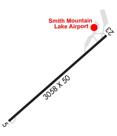
Runway Identifications
Runway Identification: 05/23
Length: 3058 ft
Width: 50 ft
Surface: ASPHALT-FAIR CONDITION
Edge lights: Medium Intensity

Treatment: NONE

 Runway: 05   Runway: 23
Mag heading: 54°Mag heading: 234°
Rwy Slope: 1.22% UpRwy Slope: -1.22% Down
Approach: Approach:
Pattern: Left TrafficPattern: Left Traffic
Markings: NONSTANDARDMarkings: NONSTANDARD
Marking Condition: GOOD; RWY 05 MRKGS WRONG SIZE ARROWS.Marking Condition: GOOD; RWY 23 MRKGS WRONG RWY WIDTH.
Arresting Dev: Arresting Dev:
Lat & Long: N3706.3  W07935.8Lat. & Long.: N3706.6  W07935.3
Elev: 854.7 ft. MSLElev: 892.0 ft. MSL
TCH: TCH:
Visual Glide Path: Visual Glide Path:
Displaced Threshold: 250 feetDisplaced Threshold: No
Touchdown Zone: YESTouchdown Zone: YES
Touchdown Elev.: 892.2 feetTouchdown Elev.: 892.2 feet
Visual Glide Slope: Visual Glide Slope:
RVR Equipment: RVR Equipment:
RVV Equipment: NORVV Equipment: NO
Approach Lights: Approach Lights:
REIL: NOREIL: YES
Centerline Lights: NOCenterline Lights: NO
Touchdown lights: NOTouchdown lights: NO
Runway Category: Runway with a Visual ApproachRunway Category: Runway with a Non-precision Approach
Declared Distances: Declared Distances:
Obstructions: TREESObstructions: TREE
Marked: NOT Marked/LightedMarked: NOT Marked/Lighted
Clearance slope: 2:1; APCH SLOPE 7:1 TO DSPLCD THR BASED.Clearance slope: 1:1
Obstruction height: 43 feet AGLObstruction height: 23 feet AGL
Dist. from runway: 290 feetDist. from runway: 238 feet
Centerline offset: 127 right of centerlineCenterline offset: 122 feet left of centerline
Comments: RY 05 HAS +12 FT ROAD AT THLD 100 FT R. PWR POLE 128 FT RIGHT OF APCH 86 FT FM THLD.Comments:
C:1/P: