Click here for more info on on SMS!

KW81

CREWE MUNI
CREWE
VA
Time Zone: Eastern
Lat: N 3710.9
Long: W 07805.9
Elev: 422
Var: +10
Longest Runway: 3300
AWOS: 119.05
CTAF: 122.8

FBO & Flight Services info for KW81

FBOs: Update your Fuel Prices

CREWE MUN ARPTPh: 434-645-9453
-
Freq: 122.8
Service
Jet
100LL
SAF
MoGas
Full        Last Update: 04/08/2024 10:23

Self  7.85    
 Address: 2372 INDIAN OAK RD   CREWE, VA 23930
AWOS
-
Freq: 119.05  
If you are an FBO, call 1-203-262-1700 to update your info or email: FltPlan.Advertising@garmin.com
Advertise your FBO on FltPlan.com

Runway & Approach Info for KW81
Rwy
Length
Land Dist**
Approach*
  Rwy
Length
Land Dist**
Approach*
15
3300x60  3023'          
 
  
33
  3300x60  3300'          
 
 * only ILS, LOC, LDA, and SDF approaches to a specific runway are shown
** For any Declared Landing Distance Available, please see A/FD or Approach plates
Runway Weight Capability (lbs.) Help
Runway IDSingle WheelDouble WheelDouble Tandem WheelDual Double Wheel
15/3312,000N/AN/AN/A
These numbers are Advisory and are not limits.   The Airport Manager should have more accurate Weight Limits
Approach Charts
Approaches    
Current Weather/Notams
Customs Information Send updates to Support@FltPlan.com
Customs Not Available
Database effective 04/18/2024
Airport Diagram of KW81
Airport Diagram might not be current.

Facility Name: CREWE MUNI
City Name: CREWE
County: NOTTOWAY
State abbrev: VA
State Name: VIRGINIA
   
Ownership: PUBLICLY OWNED
Use: OPEN TO THE PUBLIC
Owner's Name: TOWN OF CREWE
Address: 125 E CAROLINA AVE
 CREWE, VA 23930
Owner's Phone: 434-645-9453
  
Manager's Name: JAY SCUDDER
Address: 125 E CAROLINA AVE
 CREWE, VA 23930
Phone: 434-645-1191
   
FAA Region: EASTERN
FAA Field Office: DCA


Sunrise / Sunset times for CREWE MUNI

DateSunriseSunset
04/19/24 Friday6:3219:52
04/20/24 Saturday6:3019:53
04/21/24 Sunday6:2919:53
04/22/24 Monday6:2819:54
04/23/24 Tuesday6:2619:55
04/24/24 Wednesday6:2519:56
04/25/24 Thursday6:2419:57
04/26/24 Friday6:2319:58
04/27/24 Saturday6:2219:59
04/28/24 Sunday6:2020:00
04/29/24 Monday6:1920:01
04/30/24 Tuesday6:1820:02
05/01/24 Wednesday6:1720:02
05/02/24 Thursday6:1620:03

Airport Facilities

Airport Attendance ScheduleUNATTENDED; ARPT UNATNDD CONTACT TOWN MGR FOR ASSISTANCE AT 434-645-9453
Airport Status OPERATIONAL (This Status can change at any time - please check NOTAMS)
Airport Lighting ScheduleFOR MIRL RWY 15/33 KEY CTAF 5 TIMES ON; 3 TIMES OFF.
Airport Storage AvailableTie Downs
Extra Services AvailableNONE
Wind IndicatorYES - (lighted)
Control TowerNO
CTAF Frequency122.800
Unicom Frequency122.800
Rotating Beacon ColorWG
Segmented CircleNO
Landing FeeNO

Airport Inspection Data

Airport InspectedSTATE - performed by STATE AERONAUTICAL PERSONNEL
Inspection Date08/08/2023

Airport Services

Type of Fuel AvailableGrade 100LL
Airframe Repair ServiceNONE
Power Plant Repair ServiceNONE

Geographic Data

LatitudeN3710.9
LongitudeW07805.9 (ESTIMATED)
Arpt Elevation422ft (SURVEYED)
Magnetic Variation10W
1 miles Eof CREWE
Traffic Pattern Altitude
Sectional ChartWASHINGTON

Aircraft Data

Operations (Reported)YearlyAvg. Daily
General Aviation Transient 8502
General Aviation Local 31919
Air Taxi 00
Commerical 00
Commuter 00
Military 1200
Aircraft based on Field
General Aviation Singles 12
General Aviation Multi 1
Jet Aircraft 0
General Aviation Helicopters 0
Military Aircraft 0
Gliders 0
Ultralights 1

FAA Services

FSS on field NO
FSS tie-in LEESBURG
FSS Phone 1-800-WX-BRIEF
Who issues Notams DCA
Notam D service at airport YES
ARTCC Name WASHINGTON

Federal Status

Airport Certification
Aircraft Rescue & Firefighting IndexNone
Airport of EntryNo
Custom Landing RightsNo
Joint Civil/MilitaryNo
Military Landing rightsNo

Remarks

FOR CD CTC WASHINGTON ARTCC AT 703-771-3587.
RWY 15/3 3 RWY HAS LRG CRACKS.
Airport Communications & Frequencies:
CTAF Frequency:
122.800
Unicom Frequency:
122.800
Remarks
  • APCH/DEP SVC PRVDD BY WASHINGTON ARTCC ON FREQS 118.75/377.10 (GREEN BAY RCAG).
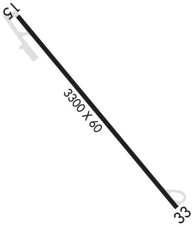
  • Runway Identifications
    Runway Identification: 15/33
    Length: 3300 ft
    Width: 60 ft
    Surface: ASPHALT-POOR CONDITION
    Edge lights: Medium Intensity

    Treatment: NONE

     Runway: 15   Runway: 33
    Mag heading: 150°Mag heading: 330°
    Rwy Slope: -.97% DownRwy Slope: .97% Up
    Approach: Approach:
    Pattern: Left TrafficPattern: Left Traffic
    Markings: NONPRECISION INSTRUMENTMarkings: BASIC
    Marking Condition: POOR; RWY 15 DSPLD TSHLD MARKINGS IN POOR CONDITION. OLD MARKINGS SHOWING THRUMarking Condition: POOR; MRKGS FADED.
    Arresting Dev: Arresting Dev:
    Lat & Long: N3711.1  W07806.1Lat. & Long.: N3710.7  W07805.7
    Elev: 417.1 ft. MSLElev: 385.0 ft. MSL
    TCH: TCH:
    Visual Glide Path: Visual Glide Path:
    Displaced Threshold: 277 feetDisplaced Threshold: No
    Touchdown Zone: YESTouchdown Zone: YES
    Touchdown Elev.: 422.0 feetTouchdown Elev.: 417.5 feet
    Visual Glide Slope: Visual Glide Slope:
    RVR Equipment: RVR Equipment:
    RVV Equipment: NORVV Equipment: NO
    Approach Lights: Approach Lights:
    REIL: NOREIL: NO
    Centerline Lights: NOCenterline Lights: NO
    Touchdown lights: NOTouchdown lights: NO
    Runway Category: Runway with a Visual ApproachRunway Category: Runway with a Visual Approach
    Declared Distances: TORA:3300' TODA:3300' ASDA:3023' LDA:3023'Declared Distances:
    Obstructions: TREEObstructions: TREE
    Marked: NOT Marked/LightedMarked: NOT Marked/Lighted
    Clearance slope: 6:1; APCH RATIO 11:1 TO DTHR.Clearance slope: 30:1
    Obstruction height: 57 feet AGLObstruction height: 85 feet AGL
    Dist. from runway: 569 feetDist. from runway: 2825 feet
    Centerline offset: 121 left of centerlineCenterline offset: 237 feet right of centerline
    Comments: RISING GROUND OFF THE END OF RY 15.Comments:
    C:/P: