Current Weather/Notams (Metars, TAFs, Notams, NWS Forecast, PIREPS, and nearby weather)
Customs Information Send updates to Support@FltPlan.com
Customs Not Available
Database effective 05/16/2024
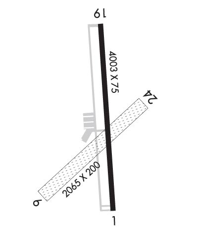
Airport Diagram might not be current. Facility Name: WILLIAM M TUCK City Name: SOUTH BOSTON County: HALIFAX State abbrev: VA State Name: VIRGINIA Ownership: PUBLICLY OWNED Use: OPEN TO THE PUBLIC Owner's Name: COUNTY OF HALIFAX Address: PO BOX 699 HALIFAX, VA 24558 Owner's Phone: 434-476-3300 Manager's Name: OTIS VAUGHAN Address: PO BOX 699 HALIFAX, VA 24558 Phone: 434-476-3300 FAA Region: EASTERN FAA Field Office: DCA
Runway Identifications Help
Runway Identification: 01/19 Length: 4003 ftWidth: 75 ftSurface: ASPHALT-GOOD CONDITIONEdge lights: Medium Intensity Treatment: NONE Runway: 01 Runway: 19 Mag heading: 5° Mag heading: 185° Rwy Slope: .93% Up Rwy Slope: -.93% Down Approach: Approach: Pattern: Left Traffic Pattern: Left Traffic Markings: NONPRECISION INSTRUMENT Markings: NONPRECISION INSTRUMENT Marking Condition: GOOD Marking Condition: GOOD Arresting Dev: Arresting Dev: Lat & Long: N3642.3 W07850.9 Lat. & Long.: N3642.9 W07850.9 Elev: 382.5 ft. MSL Elev: 419.8 ft. MSL TCH: 59 ft. AGL TCH: 41 ft. AGL Visual Glide Path: 3.00 degrees Visual Glide Path: 3.00 degrees Displaced Threshold: No Displaced Threshold: No Touchdown Zone: YES Touchdown Zone: YES Touchdown Elev.: 409.8 feet Touchdown Elev.: 419.8 feet Visual Glide Slope: 2-Light PAPI on LEFT side of Runway Visual Glide Slope: 2-Light PAPI on LEFT side of Runway RVR Equipment: RVR Equipment: RVV Equipment: NO RVV Equipment: NO Approach Lights: Approach Lights: REIL: YES REIL: YES Centerline Lights: NO Centerline Lights: NO Touchdown lights: NO Touchdown lights: NO Runway Category: Runway with a Non-precision Approach Runway Category: Runway with a Visual Approach Declared Distances: Declared Distances: Obstructions: TREES Obstructions: TREE Marked: NOT Marked/Lighted Marked: NOT Marked/Lighted Clearance slope: 10:1 Clearance slope: 15:1 Obstruction height: 28 feet AGL Obstruction height: 42 feet AGL Dist. from runway: 481 feet Dist. from runway: 861 feet Centerline offset: 265 left of centerline Centerline offset: 100 feet right of centerline Comments: 5 FT BRUSH 150 FT LEFT AND RIGHT OF RWY CNTRLN. Comments:
Runway Identification: 06/24 Length: 2065 ftWidth: 200 ftSurface: GRASS-GOOD CONDITIONEdge lights: Treatment: NONE Runway: 06 Runway: 24 Mag heading: 56° Mag heading: 236° Rwy Slope: .69% Up Rwy Slope: -.69% Down Approach: Approach: Pattern: Left Traffic Pattern: Left Traffic Markings: Markings: Marking Condition: RY 06 OUTLINED WITH YELLOW CONES. Marking Condition: RY 24 OUTLINED WITH YELLOW CONES. Arresting Dev: Arresting Dev: Lat & Long: N3642.4 W07851.1 Lat. & Long.: N3642.6 W07850.8 Elev: 375.6 ft. MSL Elev: 389.8 ft. MSL TCH: TCH: Visual Glide Path: Visual Glide Path: Displaced Threshold: No Displaced Threshold: No Touchdown Zone: YES Touchdown Zone: YES Touchdown Elev.: 391.2 feet Touchdown Elev.: 391.2 feet Visual Glide Slope: Visual Glide Slope: RVR Equipment: RVR Equipment: RVV Equipment: NO RVV Equipment: NO Approach Lights: Approach Lights: REIL: NO REIL: NO Centerline Lights: NO Centerline Lights: NO Touchdown lights: NO Touchdown lights: NO Runway Category: Runway with a Visual Approach Runway Category: Runway with a Visual Approach Declared Distances: Declared Distances: Obstructions: TREES Obstructions: TREES Marked: NOT Marked/Lighted Marked: NOT Marked/Lighted Clearance slope: 13:1 Clearance slope: 9:1 Obstruction height: 69 feet AGL Obstruction height: 70 feet AGL Dist. from runway: 1134 feet Dist. from runway: 891 feet Centerline offset: 143 right of centerline Centerline offset: 70 feet right of centerline Comments: Comments: