Click here for more info on on SMS!

KW75

HUMMEL FIELD
SALUDA
VA
Time Zone: Eastern
Lat: N 3736.1
Long: W 07626.8
Elev: 30
Var: +10
Longest Runway: 2167
AWOS: 118.45
CTAF: 123.0

FBO & Flight Services info for KW75

FBOs: Update your Fuel Prices
Hummel Field is a public use airport located six nautical miles east of the central business district of Saluda, in Middlesex County, Virginia, United States. It is owned by the County Board of Supervisors.
Ph: 804-758-0538 Fax: 804-758-0061 Freq: 123.0Website-
Service
Jet
100LL
SAF
MoGas
Fuel Avail: available 24/7
Full        Caution: Fuel prices have not been updated in 48 days.
Last Update: 03/08/2024 15:34

Self  5.53    
Misc. Info: Address: CO COURT HSE   SALUDA, VA 23149

AWOSPh: 804-758-8592
-
Freq: 118.45  
If you are an FBO, call 1-203-262-1700 to update your info or email: FltPlan.Advertising@garmin.com
Advertise your FBO on FltPlan.com

Runway & Approach Info for KW75
Rwy
Length
Land Dist**
Approach*
  Rwy
Length
Land Dist**
Approach*
01
2167x45  2042'          
 
  
19
  2167x45  2167'          
 
 * only ILS, LOC, LDA, and SDF approaches to a specific runway are shown
** For any Declared Landing Distance Available, please see A/FD or Approach plates
Runway Weight Capability (lbs.) Help
Runway IDSingle WheelDouble WheelDouble Tandem WheelDual Double Wheel
01/1912,500N/AN/AN/A
These numbers are Advisory and are not limits.   The Airport Manager should have more accurate Weight Limits
Approach Charts
Approaches    
Current Weather/Notams
Customs Information Send updates to Support@FltPlan.com
Customs Not Available
Database effective 05/16/2024
Airport Diagram of KW75
Airport Diagram might not be current.

Facility Name: HUMMEL FLD
City Name: SALUDA; TOPPING IS THE CITY CLOSEST TO THE APT. APT IS 2 MILES ENE.
County: MIDDLESEX
State abbrev: VA
State Name: VIRGINIA
   
Ownership: PUBLICLY OWNED
Use: OPEN TO THE PUBLIC
Owner's Name: COUNTY BOARD OF SUPERVISORS
Address: 877 GENERAL PULLER HWY, P.O. BOX 428
 SALUDA, VA 23149
Owner's Phone: 804-758-4330
  
Manager's Name: BETTY MUNCY; APT PHYSICAL ADDRESS IS: 310 PLANEVIEW ROAD TOPPING, VA 23169
Address: 877 GENERAL PULLER HWY, P.O. BOX 428
 SALUDA, VA 23149
Phone: 804-758-4330
   
FAA Region: EASTERN
FAA Field Office: DCA
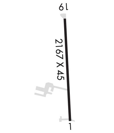

Sunrise / Sunset times for HUMMEL FLD

DateSunriseSunset
04/24/24 Wednesday6:1819:50
04/25/24 Thursday6:1719:51
04/26/24 Friday6:1519:52
04/27/24 Saturday6:1419:53
04/28/24 Sunday6:1319:54
04/29/24 Monday6:1219:55
04/30/24 Tuesday6:1119:56
05/01/24 Wednesday6:1019:57
05/02/24 Thursday6:0819:58
05/03/24 Friday6:0719:58
05/04/24 Saturday6:0619:59
05/05/24 Sunday6:0520:00
05/06/24 Monday6:0420:01
05/07/24 Tuesday6:0320:02

Airport Facilities

Airport Attendance Schedule7 Days A Week 0800-1600; UNATNDD THANKSGIVING, CHRISTMAS DAY AND NEW YEAR'S.
Airport Status OPERATIONAL (This Status can change at any time - please check NOTAMS)
Airport Lighting ScheduleACTVT MIRL RY 01/19 - CTAF.
Airport Storage AvailableTie Downs
Extra Services AvailableCrop Dusting, Flight Instruction, Aircraft Rental, Glider Towing
Wind IndicatorYES - (lighted)
Control TowerNO
CTAF Frequency123.000
Unicom Frequency123.000
Rotating Beacon ColorWG
Segmented CircleNO
Landing Fee

Airport Inspection Data

Airport InspectedSTATE - performed by STATE AERONAUTICAL PERSONNEL
Inspection Date06/15/2023

Airport Services

Type of Fuel AvailableGrade 100LL
Airframe Repair ServiceMAJOR
Power Plant Repair ServiceMAJOR

Geographic Data

LatitudeN3736.1
LongitudeW07626.8 (ESTIMATED)
Arpt Elevation30ft (SURVEYED)
Magnetic Variation10W
6 miles Eof SALUDA; TOPPING IS THE CITY CLOSEST TO THE APT. APT IS 2 MILES ENE.
Traffic Pattern Altitude
Sectional ChartWASHINGTON

Aircraft Data

Operations (Reported)YearlyAvg. Daily
General Aviation Transient 9563
General Aviation Local 1159732
Air Taxi 00
Commerical 00
Commuter 00
Military 2821
Aircraft based on Field
General Aviation Singles 31
General Aviation Multi 1
Jet Aircraft 0
General Aviation Helicopters 0
Military Aircraft 0
Gliders 0
Ultralights 0

FAA Services

FSS on field NO
FSS tie-in LEESBURG
FSS Phone 1-800-WX-BRIEF
Who issues Notams DCA
Notam D service at airport YES
ARTCC Name WASHINGTON

Federal Status

Airport Certification
Aircraft Rescue & Firefighting IndexNone
Airport of EntryNo
Custom Landing RightsNo
Joint Civil/MilitaryNo
Military Landing rightsNo

Remarks

DRAINAGE SWALES FULL LENGTH OF RY ON BOTH SIDES; USE OF EXIT IN FRONT OF HUMMEL AVIATION ADVISED.
DEPARTING RY 18/36 CLIMB TO 500 FT BEFORE ANY TURN OUT; ARRIVING ACFT USE WIDE PAT TO AVOID POPULATED AREAS EAST & WEST OF ARPT.
BIRDS AND DEER ON & INVOF ARPT DURING WINTER.
FOR CD CTC NORFOLK APCH AT 757-464-0757.
Airport Communications & Frequencies:
CTAF Frequency:
123.000
Unicom Frequency:
123.000
NORFOLK Primary Approach Frequencies:  
126.05
370.925
NORFOLK Primary Departure Frequencies:  
126.05
370.925
Runway Identifications
Runway Identification: 01/19
Length: 2167 ft
Width: 45 ft
Surface: ASPHALT-GOOD CONDITION
Edge lights: Medium Intensity

Treatment: NONE

 Runway: 01   Runway: 19
Mag heading: Mag heading: 186°
Rwy Slope: -.32% DownRwy Slope: .32% Up
Approach: Approach:
Pattern: Left TrafficPattern: Left Traffic
Markings: NONPRECISION INSTRUMENTMarkings: BASIC
Marking Condition: GOODMarking Condition: GOOD
Arresting Dev: Arresting Dev:
Lat & Long: N3736.0  W07626.8Lat. & Long.: N3736.3  W07626.8
Elev: 29.8 ft. MSLElev: 22.9 ft. MSL
TCH: TCH:
Visual Glide Path: Visual Glide Path:
Displaced Threshold: 125 feetDisplaced Threshold: No
Touchdown Zone: YESTouchdown Zone: YES
Touchdown Elev.: 30.0 feetTouchdown Elev.: 30.0 feet
Visual Glide Slope: SYSTEM OF PANELS ON LEFT SIDE OF RUNWAY (May NOT Be Lighted); OTS INDEFLY.Visual Glide Slope: SYSTEM OF PANELS ON RIGHT SIDE OF RUNWAY (May NOT Be Lighted); OTS INDEFLY.
RVR Equipment: RVR Equipment:
RVV Equipment: NORVV Equipment: NO
Approach Lights: Approach Lights:
REIL: NOREIL: NO
Centerline Lights: NOCenterline Lights: NO
Touchdown lights: NOTouchdown lights: NO
Runway Category: Runway with a Non-precision ApproachRunway Category: Runway with a Visual Approach
Declared Distances: Declared Distances:
Obstructions: TREE; ROAD RUNS PERPENDICULAR TO RY END.Obstructions: TREE
Marked: NOT Marked/LightedMarked: NOT Marked/Lighted
Clearance slope: 13:1; APCH RATIO 14:1 TO DSPLCD THLD.Clearance slope: 22:1
Obstruction height: 92 feet AGLObstruction height: 67 feet AGL
Dist. from runway: 1463 feetDist. from runway: 1713 feet
Centerline offset: 173 left of centerlineCenterline offset: 178 feet right of centerline
Comments: 18 FT BUILDING LOCATED 200 FT FM PAVEMENT END, 204 FT RIGHT OF CENTERLINE.Comments: FIELD IMMEDIATELY NORTH OF RY 19. 7 FT CORN GROWING AT TIMES.
C:2/P: