Current Weather/Notams (Metars, TAFs, Notams, NWS Forecast, PIREPS, and nearby weather)
Customs Information Send updates to Support@FltPlan.com
Customs Not Available
Database effective 05/16/2024
Airport Diagram might not be current.
|
| Facility Name: | LUNENBURG COUNTY |
| City Name: | KENBRIDGE |
| County: | LUNENBURG |
| State abbrev: | VA |
| State Name: | VIRGINIA |
| | |
| Ownership: | PUBLICLY OWNED |
| Use: | OPEN TO THE PUBLIC |
| Owner's Name: | LUNENBURG COUNTY |
| Address: | 11409 COURTHOUSE RD, ATTN: COUNTY ADMINISTRATOR |
| | LUNENBURG, VA 23952 |
| Owner's Phone: | 434-696-2142 |
| | |
| Manager's Name: | LARRY WAY |
| Address: | 634 AIRPORT ROAD |
| | VICTORIA, VA 23974 |
| Phone: | 434-262-3750 |
| | |
| FAA Region: | EASTERN |
| FAA Field Office: | DCA |
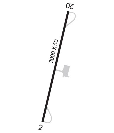
Runway Identifications
Runway Identification: 02/20Length: 3000 ft
Width: 50 ft
Surface: ASPHALT-POOR CONDITION
Edge lights: Low IntensityTreatment: AGGREGATE FRICTION SEAL COAT
| | Runway: 02 | | Runway: 20 |
| Mag heading: | 23° | Mag heading: | 203° |
| Rwy Slope: | .43% Up | Rwy Slope: | -.43% Down |
| Approach: | | Approach: | |
| Pattern: | Left Traffic | Pattern: | Left Traffic |
| Markings: | BASIC | Markings: | BASIC |
| Marking Condition: | FAIR | Marking Condition: | FAIR |
| Arresting Dev: | | Arresting Dev: | |
| Lat & Long: | N3657.4 W07811.2 | Lat. & Long.: | N3657.9 W07811.0 |
| Elev: | 512.0 ft. MSL | Elev: | 525.0 ft. MSL |
| TCH: | 26 ft. AGL | TCH: | 26 ft. AGL |
| Visual Glide Path: | 5.00 degrees | Visual Glide Path: | 5.00 degrees |
| Displaced Threshold: | No | Displaced Threshold: | No |
| Touchdown Zone: | YES | Touchdown Zone: | YES |
| Touchdown Elev.: | 526.0 feet | Touchdown Elev.: | 526.0 feet |
| Visual Glide Slope: | SYSTEM OF PANELS ON LEFT SIDE OF RUNWAY (May NOT Be Lighted) | Visual Glide Slope: | SYSTEM OF PANELS ON LEFT SIDE OF RUNWAY (May NOT Be Lighted) |
| RVR Equipment: | | RVR Equipment: | |
| RVV Equipment: | NO | RVV Equipment: | NO |
| Approach Lights: | | Approach Lights: | |
| REIL: | NO | REIL: | NO |
| Centerline Lights: | NO | Centerline Lights: | NO |
| Touchdown lights: | NO | Touchdown lights: | NO |
| Runway Category: | Runway with a Non-precision Approach | Runway Category: | Runway with a Non-precision Approach |
| Declared Distances: | | Declared Distances: | |
| Obstructions: | TREE | Obstructions: | TREE |
| Marked: | NOT Marked/Lighted | Marked: | NOT Marked/Lighted |
| Clearance slope: | 3:1 | Clearance slope: | 1:1 |
| Obstruction height: | 37 feet AGL | Obstruction height: | 53 feet AGL |
| Dist. from runway: | 318 feet | Dist. from runway: | 283 feet |
| Centerline offset: | 231 right of centerline | Centerline offset: | 176 feet right of centerline |
| Comments: | | Comments: | TREE AT 195 FT FM RWY END, 216 FT RIGHT ON APCH. |

