Approach Charts
| FltPlan does not have IFR approach charts available for KW28. |
Current Weather/Notams (Metars, TAFs, Notams, NWS Forecast, PIREPS, and nearby weather)
Customs Information Send updates to Support@FltPlan.com
Customs Not Available
Database effective 04/18/2024
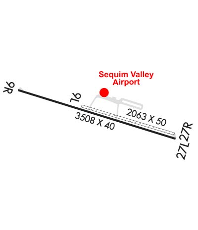
Airport Diagram might not be current.
|
| Facility Name: | SEQUIM VALLEY |
| City Name: | SEQUIM |
| County: | CLALLAM |
| State abbrev: | WA |
| State Name: | WASHINGTON |
| | |
| Ownership: | PRIVATELY OWNED |
| Use: | OPEN TO THE PUBLIC |
| Owner's Name: | ANDY SALLEE |
| Address: | 468 DOROTHY HUNT LANE |
| | SEQUIM, WA 98382 |
| Owner's Phone: | 360-683-4444 |
| | |
| Manager's Name: | ANDY SALLEE |
| Address: | PO BOX 101 |
| | CARLSBORG, WA 98324 |
| Phone: | 360-670-3083 |
| | |
| FAA Region: | NORTHWEST MOUNTAIN |
| FAA Field Office: | SEA |
Runway Identifications
Runway Identification: 09/27Length: 3508 ft
Width: 40 ft
Surface: ASPHALT
Edge lights: Low IntensityTreatment: NONE
| | Runway: 09 | | Runway: 27 |
| Mag heading: | N/A | Mag heading: | N/A |
| Rwy Slope: | .43% Up | Rwy Slope: | -.43% Down |
| Approach: | | Approach: | |
| Pattern: | Right Traffic | Pattern: | Left Traffic |
| Markings: | BASIC | Markings: | BASIC |
| Marking Condition: | GOOD | Marking Condition: | GOOD |
| Arresting Dev: | | Arresting Dev: | |
| Lat & Long: | N4806.0 W12311.7 | Lat. & Long.: | N4805.8 W12310.9 |
| Elev: | 136.0 ft. MSL | Elev: | 151.0 ft. MSL |
| TCH: | | TCH: | |
| Visual Glide Path: | | Visual Glide Path: | |
| Displaced Threshold: | No | Displaced Threshold: | No |
| Touchdown Zone: | YES | Touchdown Zone: | YES |
| Touchdown Elev.: | 136.0 feet | Touchdown Elev.: | 151.0 feet |
| Visual Glide Slope: | | Visual Glide Slope: | |
| RVR Equipment: | | RVR Equipment: | |
| RVV Equipment: | NO | RVV Equipment: | NO |
| Approach Lights: | | Approach Lights: | |
| REIL: | NO | REIL: | NO |
| Centerline Lights: | NO | Centerline Lights: | NO |
| Touchdown lights: | NO | Touchdown lights: | NO |
| Runway Category: | Runway with a Visual Approach | Runway Category: | Runway with a Visual Approach |
| Declared Distances: | | Declared Distances: | |
| Obstructions: | TREES | Obstructions: | TREES |
| Marked: | NOT Marked/Lighted | Marked: | NOT Marked/Lighted |
| Clearance slope: | 11:1 | Clearance slope: | 7:1 |
| Obstruction height: | 90 feet AGL | Obstruction height: | 65 feet AGL |
| Dist. from runway: | 1243 feet | Dist. from runway: | 686 feet |
| Centerline offset: | | Centerline offset: | 25 feet right of centerline |
| Comments: | RWY 09 2 FT SIGN, 37 FT L AND 3 FT SIGN, 45 FT L OF CNTRLN 4 FT FM RWY END. | Comments: | RWY 27 FENCE POST 4.5 FT HIGH, 38 FT LEFT RWY CNTRLN. RWY 27 IRRIGATION PIPE PARL ONE THIRD OF RWY; 2 FT SIGN AT 36 FT RIGHT OF CNTRLN. |


