Click here for more info on on SMS!

KW24

FALWELL
LYNCHBURG
VA
Time Zone: Eastern
Lat: N 3722.7
Long: W 07907.3
Elev: 939
Var: +09
Longest Runway: 2932
CTAF: 123.0

FBO & Flight Services info for KW24

FBOs: Update your Fuel Prices
Providing high quality fuel and services to you and your customers, from Phillips 66 Aviation.
Ph: 434-845-8769 Fax: 434-528-1992 Freq: 123.0Website-
                               
Service
Jet
100LL
SAF
MoGas
Fuel Avail: ONLY 100LL AVAILABLE
Full  6.36    Caution: Fuel prices have not been updated in 35 days.
Last Update: 03/22/2024 08:18

Self        
Misc. Info: Address: 4332 RICHMON HWY   LYNCHBURG, VA 24501

If you are an FBO, call 1-203-262-1700 to update your info or email: FltPlan.Advertising@garmin.com
Advertise your FBO on FltPlan.com

Runway & Approach Info for KW24
Rwy
Length
Land Dist**
Approach*
  Rwy
Length
Land Dist**
Approach*
10
2932x50  2932'          
 
  
28
  2932x50  2932'          
 
 * only ILS, LOC, LDA, and SDF approaches to a specific runway are shown
** For any Declared Landing Distance Available, please see A/FD or Approach plates
Runway Weight Capability (lbs.) Help
Runway IDSingle WheelDouble WheelDouble Tandem WheelDual Double Wheel
10/28N/AN/AN/AN/A
These numbers are Advisory and are not limits.   The Airport Manager should have more accurate Weight Limits
Approach Charts
Approaches    
Current Weather/Notams
Customs Information Send updates to Support@FltPlan.com
Customs Not Available
Database effective 05/16/2024
Airport Diagram of KW24
Airport Diagram might not be current.

Facility Name: FALWELL
City Name: LYNCHBURG
County: LYNCHBURG
State abbrev: VA
State Name: VIRGINIA
   
Ownership: PRIVATELY OWNED
Use: OPEN TO THE PUBLIC
Owner's Name: 4180 RICHMOND HIGHWAY LLC
Address: FREEDOM AVIATION, 310 HANGER ROAD
 LYNCHBURG, VA 24502
Owner's Phone: 434-582-3028
  
Manager's Name: ROGER BECK
Address: MCLAREN CORP., 4332 RICHMOND HWY
 LYNCHBURG, VA 24501
Phone: 434-845-8769
   
FAA Region: EASTERN
FAA Field Office: DCA


Sunrise / Sunset times for FALWELL

DateSunriseSunset
04/25/24 Thursday6:2820:01
04/26/24 Friday6:2720:02
04/27/24 Saturday6:2520:03
04/28/24 Sunday6:2420:04
04/29/24 Monday6:2320:05
04/30/24 Tuesday6:2220:06
05/01/24 Wednesday6:2120:07
05/02/24 Thursday6:2020:08
05/03/24 Friday6:1820:09
05/04/24 Saturday6:1720:10
05/05/24 Sunday6:1620:10
05/06/24 Monday6:1520:11
05/07/24 Tuesday6:1420:12
05/08/24 Wednesday6:1320:13

Airport Facilities

Airport Attendance ScheduleAPR-OCT 7 Days A Week 0700-1900, 7 Days A Week 0700-1800
Airport Status OPERATIONAL (This Status can change at any time - please check NOTAMS)
Airport Lighting ScheduleACTIVATE TRIL RWY 28 CTAF
Airport Storage AvailableTie Downs, Hanger
Extra Services AvailableCharter, Flight Instruction, Aircraft Rental, Annual Surveying
Wind IndicatorYES - (lighted)
Control TowerNO
CTAF Frequency123.000
Unicom Frequency123.000
Rotating Beacon Color
Segmented CircleNO
Landing FeeNO

Airport Inspection Data

Airport InspectedSTATE - performed by STATE AERONAUTICAL PERSONNEL
Inspection Date08/25/2023

Airport Services

Type of Fuel AvailableGrade 100LL
Airframe Repair ServiceMAJOR
Power Plant Repair ServiceMAJOR

Geographic Data

LatitudeN3722.7
LongitudeW07907.3 (ESTIMATED)
Arpt Elevation939ft (SURVEYED)
Magnetic Variation09W
3 miles SEof LYNCHBURG
Traffic Pattern Altitude800
Sectional ChartCINCINNATI

Aircraft Data

Operations (Reported)YearlyAvg. Daily
General Aviation Transient 26977
General Aviation Local 782221
Air Taxi 00
Commerical 00
Commuter 00
Military 00
Aircraft based on Field
General Aviation Singles 9
General Aviation Multi 0
Jet Aircraft 0
General Aviation Helicopters 0
Military Aircraft 0
Gliders 0
Ultralights 0

FAA Services

FSS on field NO
FSS tie-in LEESBURG
FSS Phone 1-800-WX-BRIEF
Who issues Notams DCA
Notam D service at airport YES
ARTCC Name WASHINGTON

Federal Status

Airport Certification
Aircraft Rescue & Firefighting IndexNone
Airport of EntryNo
Custom Landing RightsNo
Joint Civil/MilitaryNo
Military Landing rightsNo

Remarks

NO TGL.
DEER ON AND INVOF ARPT.
ROA TWR SVCS AVBL AT 540-563-1307.
FOR CD CTC ROANOKE APCH AT 540-563-1307.
RUNWAY 28 CLOSED FOR TAKE-OFF RUNWAY 10 CLOSED FOR LANDING
RWY 10/2 8 LAND RY 28 (WEST) TKOF RY 10 (EAST).
Airport Communications & Frequencies:
CTAF Frequency:
123.000
Unicom Frequency:
123.000
ROANOKE Primary Approach Frequencies:  
125.475 EAST OF LYH VORTAC
135.0 WEST OF LYH VORTAC
254.325
ROANOKE Primary Departure Frequencies:  
125.475 EAST OF LYH VORTAC
135.0 WEST OF LYH VORTAC
254.325
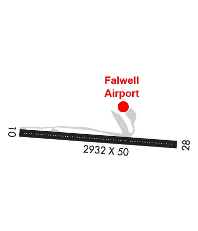
Runway Identifications
Runway Identification: 10/28
Length: 2932 ft
Width: 50 ft
Surface: ASPHALT-FAIR CONDITION
Edge lights: Medium Intensity

Treatment: NONE

 Runway: 10   Runway: 28
Mag heading: N/AMag heading: N/A
Rwy Slope: -4.66% DownRwy Slope: 4.66% Up
Approach: Approach:
Pattern: Left TrafficPattern: Left Traffic
Markings: BASICMarkings: BASIC
Marking Condition: GOODMarking Condition: GOOD
Arresting Dev: Arresting Dev:
Lat & Long: N3722.7  W07907.6Lat. & Long.: N3722.7  W07907.0
Elev: 938.0 ft. MSLElev: 801.4 ft. MSL
TCH: TCH:
Visual Glide Path: Visual Glide Path:
Displaced Threshold: NoDisplaced Threshold: No
Touchdown Zone: YESTouchdown Zone: YES
Touchdown Elev.: 939.0 feetTouchdown Elev.: 939.0 feet
Visual Glide Slope: Visual Glide Slope: TRI-COLOR VASI ON LEFT SIDE OF RUNWAY
RVR Equipment: RVR Equipment:
RVV Equipment: NORVV Equipment: NO
Approach Lights: Approach Lights:
REIL: NOREIL: NO
Centerline Lights: NOCenterline Lights: NO
Touchdown lights: NOTouchdown lights: NO
Runway Category: Runway with a Visual ApproachRunway Category: Runway with a Non-precision Approach
Declared Distances: Declared Distances:
Obstructions: TREEObstructions: TREES
Marked: NOT Marked/LightedMarked: NOT Marked/Lighted
Clearance slope: 1:1Clearance slope: 5:1
Obstruction height: 59 feet AGLObstruction height: 20 feet AGL
Dist. from runway: 315 feetDist. from runway: 310 feet
Centerline offset: 89 right of centerlineCenterline offset: 171 feet left of centerline
Comments: RWY 10 +47 FT TREE 89 FT FROM THLD 76 FT RHT.Comments: 13 FT LINE OF TREES 180 FT LEFT OF THR ON APCH.
C:2/P: