Click here for more info on on SMS!

KW13

EAGLE'S NEST
WAYNESBORO
VA
Time Zone: Eastern
Lat: N 3804.6
Long: W 07856.7
Elev: 1436
Var: +09
Longest Runway: 2004
AWOS: 118.62
CTAF: 123.05

FBO & Flight Services info for KW13

FBOs: Update your Fuel Prices
Our new FBO comes complete with pilots lounge, briefing room, restrooms, courtesy van, and vending machines. 100 LL-fuel, (available at a discount for residents and those based here) maintenance, and flight instructors are available on the field.
Ph: 540-943-4447 Fax: 540-949-7359 Freq: 123.05WebsiteE-Mail
Service
Jet
100LL
SAF
MoGas
Fuel Avail: 8A-5P
Full  6.65    Last Update: 04/12/2024 10:58

Self        
Misc. Info: Address: 249 AERO DR   WAYNESBORO, VA 22980

AWOSPh: 540-941-7570
-
Freq: 118.62  
If you are an FBO, call 1-203-262-1700 to update your info or email: FltPlan.Advertising@garmin.com
Advertise your FBO on FltPlan.com

Runway & Approach Info for KW13
Rwy
Length
Land Dist**
Approach*
  Rwy
Length
Land Dist**
Approach*
06
2004x50  2004'          
 
  
24
  2004x50  2004'          
 
 * only ILS, LOC, LDA, and SDF approaches to a specific runway are shown
** For any Declared Landing Distance Available, please see A/FD or Approach plates
Runway Weight Capability (lbs.) Help
Runway IDSingle WheelDouble WheelDouble Tandem WheelDual Double Wheel
06/24N/AN/AN/AN/A
These numbers are Advisory and are not limits.   The Airport Manager should have more accurate Weight Limits
Approach Charts
Approaches    
Current Weather/Notams
Customs Information Send updates to Support@FltPlan.com
Customs Not Available
Database effective 04/18/2024
Airport Diagram of KW13
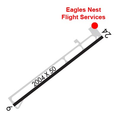
Airport Diagram might not be current.

Facility Name: EAGLE'S NEST
City Name: WAYNESBORO
County: AUGUSTA
State abbrev: VA
State Name: VIRGINIA
   
Ownership: PRIVATELY OWNED
Use: OPEN TO THE PUBLIC
Owner's Name: MICHAEL L FOGLE
Address: P. O. BOX 691236
 CHARLOTTE, NC 28227-7021
Owner's Phone: 704-576-3500
  
Manager's Name: MICHAEL T.K. ROSOLINA
Address: 249 AERO DR
 WAYNESBORO, VA 22980
Phone: 540-943-4447
   
FAA Region: EASTERN
FAA Field Office: DCA


Sunrise / Sunset times for EAGLE'S NEST

DateSunriseSunset
04/17/24 Wednesday6:3619:54
04/18/24 Thursday6:3519:55
04/19/24 Friday6:3419:56
04/20/24 Saturday6:3219:57
04/21/24 Sunday6:3119:58
04/22/24 Monday6:3019:59
04/23/24 Tuesday6:2820:00
04/24/24 Wednesday6:2720:01
04/25/24 Thursday6:2620:02
04/26/24 Friday6:2520:03
04/27/24 Saturday6:2320:04
04/28/24 Sunday6:2220:05
04/29/24 Monday6:2120:06
04/30/24 Tuesday6:2020:07

Airport Facilities

Airport Attendance Schedule7 Days A Week 0800 - 1630
Airport Status OPERATIONAL (This Status can change at any time - please check NOTAMS)
Airport Lighting ScheduleACTVT MIRL RWY 06/24 - CTAF.
Airport Storage AvailableTie Downs, Hanger
Extra Services AvailableGlider, Flight Instruction, Aircraft Rental
Wind IndicatorYES - (unlit)
Control TowerNO
CTAF Frequency123.050
Unicom Frequency123.050
Rotating Beacon ColorWG
Segmented CircleNO
Landing FeeNO

Airport Inspection Data

Airport InspectedSTATE - performed by STATE AERONAUTICAL PERSONNEL
Inspection Date04/13/2022

Airport Services

Type of Fuel AvailableGrade 100LL
Airframe Repair ServiceMAJOR
Power Plant Repair ServiceMAJOR

Geographic Data

LatitudeN3804.6
LongitudeW07856.7 (ESTIMATED)
Arpt Elevation1436ft (ESTIMATED)
Magnetic Variation09W
3 miles Wof WAYNESBORO
Traffic Pattern Altitude
Sectional ChartWASHINGTON

Aircraft Data

Operations (Reported)YearlyAvg. Daily
General Aviation Transient 32369
General Aviation Local 1001727
Air Taxi 10043
Commerical 00
Commuter 00
Military 00
Aircraft based on Field
General Aviation Singles 60
General Aviation Multi 3
Jet Aircraft 0
General Aviation Helicopters 0
Military Aircraft 0
Gliders 1
Ultralights 0

FAA Services

FSS on field NO
FSS tie-in LEESBURG
FSS Phone 1-800-WX-BRIEF
Who issues Notams DCA
Notam D service at airport YES
ARTCC Name WASHINGTON

Federal Status

Airport Certification
Aircraft Rescue & Firefighting IndexNone
Airport of EntryNo
Custom Landing RightsNo
Joint Civil/MilitaryNo
Military Landing rightsNo

Remarks

DEER ON AND INVOF ARPT.
NO REPETITIVE PRACTICE TKOFS AND LDGS AFT 0100Z.
NO GRASS LANDINGS OR TAKEOFFS EITHER SIDE OF RWY 06/24.
FOR CD CTC POTOMAC APCH AT 866-640-4124.
Airport Communications & Frequencies:
CTAF Frequency:
123.050
Unicom Frequency:
123.050
POTOMAC Primary Approach Frequencies:  
132.85
323.125
POTOMAC Primary Departure Frequencies:  
132.85
323.125
Runway Identifications
Runway Identification: 06/24
Length: 2004 ft
Width: 50 ft
Surface: ASPHALT-GOOD CONDITION
Edge lights: Medium Intensity

Treatment: NONE

 Runway: 06   Runway: 24
Mag heading: N/AMag heading: N/A
Rwy Slope: -.30% DownRwy Slope: .30% Up
Approach: Approach:
Pattern: Left TrafficPattern: Left Traffic
Markings: NUMBERS ONLYMarkings: NUMBERS ONLY
Marking Condition: GOODMarking Condition: GOOD
Arresting Dev: Arresting Dev:
Lat & Long: N3804.5  W07856.8Lat. & Long.: N3804.7  W07856.5
Elev: 1436.0 ft. MSLElev: 1430.0 ft. MSL
TCH: TCH:
Visual Glide Path: Visual Glide Path:
Displaced Threshold: NoDisplaced Threshold: No
Touchdown Zone: YESTouchdown Zone: YES
Touchdown Elev.: 1436.0 feetTouchdown Elev.: 1436.0 feet
Visual Glide Slope: Visual Glide Slope:
RVR Equipment: RVR Equipment:
RVV Equipment: NORVV Equipment: NO
Approach Lights: Approach Lights:
REIL: NOREIL: NO
Centerline Lights: NOCenterline Lights: NO
Touchdown lights: NOTouchdown lights: NO
Runway Category: Runway with a Non-precision ApproachRunway Category: Runway with a Non-precision Approach
Declared Distances: Declared Distances:
Obstructions: TREEObstructions: TREE
Marked: NOT Marked/LightedMarked: NOT Marked/Lighted
Clearance slope: 7:1Clearance slope: 6:1
Obstruction height: 38 feet AGLObstruction height: 32 feet AGL
Dist. from runway: 500 feetDist. from runway: 418 feet
Centerline offset: 113 right of centerlineCenterline offset: 132 feet left of centerline
Comments: 23 FT BRUSH AND TREES L SIDE OF RWY APPROXIMATELY 155 FT FM THR AND 108 FT FM CNTRLN.Comments:
C:/P: