Click here for more info on on SMS!

KW05

GETTYSBURG RGNL
GETTYSBURG
PA
Time Zone: Eastern
Lat: N 3950.5
Long: W 07716.5
Elev: 553
Var: +11
Longest Runway: 3100
CTAF: 122.9

FBO & Flight Services info for KW05

FBOs: Update your Fuel Prices

BLOUCH ACFT SVCSPh: 717 357 5958
-
Freq: 122.9
Service
Jet
100LL
SAF
MoGas
Fuel Avail: 100LL
Full        Last Update: 04/20/2024 12:55

Self6.506.38    
 Address: 1150 CHAMBERSBURG RD GETTYSBURG, PA 17325
If you are an FBO, call 1-203-262-1700 to update your info or email: FltPlan.Advertising@garmin.com
Advertise your FBO on FltPlan.com

Runway & Approach Info for KW05
Rwy
Length
Land Dist**
Approach*
  Rwy
Length
Land Dist**
Approach*
06
3100x60  2935'          
 
  
24
  3100x60  2561'          
 
 * only ILS, LOC, LDA, and SDF approaches to a specific runway are shown
** For any Declared Landing Distance Available, please see A/FD or Approach plates
Runway Weight Capability (lbs.) Help
Runway IDSingle WheelDouble WheelDouble Tandem WheelDual Double Wheel
06/24N/AN/AN/AN/A
These numbers are Advisory and are not limits.   The Airport Manager should have more accurate Weight Limits
Approach Charts
Approaches    
Current Weather/Notams
Customs Information Send updates to Support@FltPlan.com
Customs Not Available
Database effective 05/16/2024
Airport Diagram of KW05
Airport Diagram might not be current.

Facility Name: GETTYSBURG RGNL
City Name: GETTYSBURG
County: ADAMS
State abbrev: PA
State Name: PENNSYLVANIA
   
Ownership: PUBLICLY OWNED
Use: OPEN TO THE PUBLIC
Owner's Name: SUSQUEHANNA RGNL ARPT AUTHORITY
Address: ONE TERMINAL DRIVE, SUITE 300
 MIDDLETOWN, PA 17057
Owner's Phone: 717-948-3900
  
Manager's Name: TIM EDWARDS
Address: ONE TERMINAL DRIVE, SUITE 300
 MIDDLETOWN, PA 17057
Phone: 717-948-3900
   
FAA Region: EASTERN
FAA Field Office: HAR


Sunrise / Sunset times for GETTYSBURG RGNL

DateSunriseSunset
04/25/24 Thursday6:1619:58
04/26/24 Friday6:1519:59
04/27/24 Saturday6:1420:00
04/28/24 Sunday6:1220:01
04/29/24 Monday6:1120:02
04/30/24 Tuesday6:1020:03
05/01/24 Wednesday6:0920:04
05/02/24 Thursday6:0720:05
05/03/24 Friday6:0620:06
05/04/24 Saturday6:0520:07
05/05/24 Sunday6:0420:08
05/06/24 Monday6:0320:09
05/07/24 Tuesday6:0220:10
05/08/24 Wednesday6:0020:11

Airport Facilities

Airport Attendance ScheduleUNATTENDED
Airport Status OPERATIONAL (This Status can change at any time - please check NOTAMS)
Airport Lighting ScheduleACTVT MIRL RWY 06/24 - CTAF.
Airport Storage AvailableTie Downs
Extra Services AvailableNONE
Wind IndicatorYES - (lighted)
Control TowerNO
CTAF Frequency122.900
Unicom Frequency
Rotating Beacon ColorWG
Segmented CircleYES
Landing FeeNO

Airport Inspection Data

Airport InspectedSTATE - performed by STATE AERONAUTICAL PERSONNEL
Inspection Date02/14/2024

Airport Services

Type of Fuel AvailableGrade 100LL, JET A (freeze point -40C)
Airframe Repair ServiceMAJOR
Power Plant Repair ServiceMAJOR

Geographic Data

LatitudeN3950.5
LongitudeW07716.5 (ESTIMATED)
Arpt Elevation553ft (SURVEYED)
Magnetic Variation11W
2 miles Wof GETTYSBURG
Traffic Pattern Altitude
Sectional ChartWASHINGTON

Aircraft Data

Operations (Reported)YearlyAvg. Daily
General Aviation Transient 27007
General Aviation Local 690019
Air Taxi 00
Commerical 00
Commuter 00
Military 500
Aircraft based on Field
General Aviation Singles 26
General Aviation Multi 0
Jet Aircraft 0
General Aviation Helicopters 0
Military Aircraft 0
Gliders 0
Ultralights 0

FAA Services

FSS on field NO
FSS tie-in WILLIAMSPORT
FSS Phone 1-800-WX-BRIEF
Who issues Notams IPT
Notam D service at airport YES
ARTCC Name NEW YORK

Federal Status

Airport Certification
Aircraft Rescue & Firefighting IndexNone
Airport of EntryNo
Custom Landing RightsNo
Joint Civil/MilitaryNo
Military Landing rightsNo

Federal Agreements

NATIONAL PLAN OF INTEGRATED AIRPORT SYSTEMS (NPIAS)

Remarks

DEER AND BIRDS INVOF ARPT.
FOR CD CTC POTOMAC APCH AT 866-709-4993.
Airport Communications & Frequencies:
CTAF Frequency:
122.900
POTOMAC Primary Approach Frequencies:  
126.825
239.025
POTOMAC Primary Departure Frequencies:  
126.825
239.025
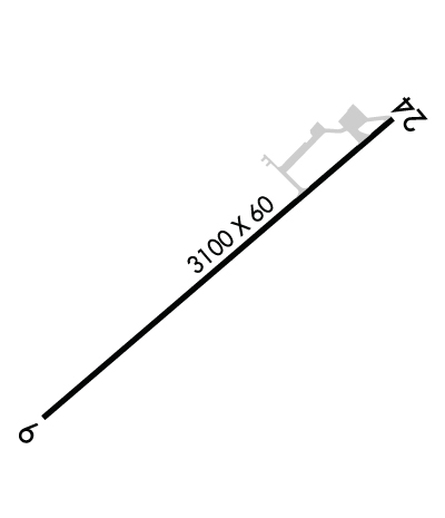
Runway Identifications
Runway Identification: 06/24
Length: 3100 ft
Width: 60 ft
Surface: ASPHALT-GOOD CONDITION
Edge lights: Medium Intensity

Treatment: NONE

 Runway: 06   Runway: 24
Mag heading: 61°Mag heading: 241°
Rwy Slope: .40% UpRwy Slope: -.40% Down
Approach: Approach:
Pattern: Left TrafficPattern: Left Traffic
Markings: NONPRECISION INSTRUMENTMarkings: BASIC
Marking Condition: GOODMarking Condition: GOOD
Arresting Dev: Arresting Dev:
Lat & Long: N3950.3  W07716.7Lat. & Long.: N3950.6  W07716.2
Elev: 539.8 ft. MSLElev: 552.3 ft. MSL
TCH: TCH:
Visual Glide Path: Visual Glide Path:
Displaced Threshold: 165 feetDisplaced Threshold: 539 feet
Touchdown Zone: YESTouchdown Zone: YES
Touchdown Elev.: 553.2 feetTouchdown Elev.: 553.1 feet
Visual Glide Slope: Visual Glide Slope:
RVR Equipment: RVR Equipment:
RVV Equipment: NORVV Equipment: NO
Approach Lights: Approach Lights:
REIL: NOREIL: NO
Centerline Lights: NOCenterline Lights: NO
Touchdown lights: NOTouchdown lights: NO
Runway Category: Runway with a Visual ApproachRunway Category: Runway with a Visual Approach
Declared Distances: Declared Distances:
Obstructions: ROADObstructions: POLE
Marked: NOT Marked/LightedMarked: MARKED
Clearance slope: 11:1; APCH RATIO 39:1 TO DTHR.Clearance slope: 10:1; RWY 24 APCH RATIO 21:1 TO DSPLCD THLD.
Obstruction height: 14 feet AGLObstruction height: 51 feet AGL
Dist. from runway: 370 feetDist. from runway: 749 feet
Centerline offset: Centerline offset: 118 feet right of centerline
Comments: Comments:
C:1/P: