Click here for more info on on SMS!

KW00

FREEWAY
BOWIE
MD
Time Zone: Eastern
Lat: N 3856.5
Long: W 07646.3
Elev: 168
Var: +10
Longest Runway: 2420
CTAF: 123.07

FBO & Flight Services info for KW00

FBOs: Update your Fuel Prices
Our office hours are from 7:30am to 6:00pm EST (7:30am to 8:00pm EDT). Medium intensity runway lighting is pilot activated by 5 clicks in 5 seconds on our unicom frequency of 123.075. We have 24-hour self-serve fuel access, a full selection of charts and plates, and a variety of pilot supplies.
Ph: 301-390-6424
-
Freq: 123.07WebsiteE-Mail
Service
Jet
100LL
SAF
MoGas
Full        Last Update: 03/22/2024 09:15

Self  5.90    
Misc. Info: Address: 3900 CHURCH RD,   BOWIE, MD 20721

If you are an FBO, call 1-203-262-1700 to update your info or email: FltPlan.Advertising@garmin.com
Advertise your FBO on FltPlan.com

Runway & Approach Info for KW00
Rwy
Length
Land Dist**
Approach*
  Rwy
Length
Land Dist**
Approach*
18
2420x40  2420'          
 
  
36
  2420x40  2190'          
 
 * only ILS, LOC, LDA, and SDF approaches to a specific runway are shown
** For any Declared Landing Distance Available, please see A/FD or Approach plates
Runway Weight Capability (lbs.) Help
Runway IDSingle WheelDouble WheelDouble Tandem WheelDual Double Wheel
18/36N/AN/AN/AN/A
These numbers are Advisory and are not limits.   The Airport Manager should have more accurate Weight Limits
Approach Charts
Approaches    
Current Weather/Notams
Customs Information Send updates to Support@FltPlan.com
Customs Not Available
Database effective 04/18/2024
Airport Diagram of KW00
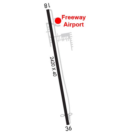
Airport Diagram might not be current.

Facility Name: FREEWAY
City Name: BOWIE
County: PRINCE GEORGES
State abbrev: MD
State Name: MARYLAND
   
Ownership: PRIVATELY OWNED
Use: OPEN TO THE PUBLIC
Owner's Name: FREEWAY AIRPORT INC.
Address: 3900 CHURCH RD
 BOWIE, MD 20721
Owner's Phone: 301-390-6424
  
Manager's Name: MATTHEW LINDQUIST
Address: 3900 CHURCH RD
 MITCHELLVILLE, MD 20716
Phone: 301-390-6424
   
FAA Region: EASTERN
FAA Field Office: DCA


Sunrise / Sunset times for FREEWAY

DateSunriseSunset
04/19/24 Friday6:2419:49
04/20/24 Saturday6:2219:50
04/21/24 Sunday6:2119:51
04/22/24 Monday6:2019:52
04/23/24 Tuesday6:1819:53
04/24/24 Wednesday6:1719:54
04/25/24 Thursday6:1619:55
04/26/24 Friday6:1419:56
04/27/24 Saturday6:1319:57
04/28/24 Sunday6:1219:58
04/29/24 Monday6:1119:59
04/30/24 Tuesday6:0920:00
05/01/24 Wednesday6:0820:00
05/02/24 Thursday6:0720:01

Airport Facilities

Airport Attendance Schedule7 Days A Week 0800-1700; UNATNDD MAJOR HOLIDAYS.
Airport Status OPERATIONAL (This Status can change at any time - please check NOTAMS)
Airport Lighting ScheduleACTVT PAPI RWYS 18 & 36; MIRL RWY 18/36 - CTAF.
Airport Storage AvailableTie Downs
Extra Services AvailableCharter, Flight Instruction, Aircraft Rental
Wind IndicatorYES - (lighted)
Control TowerNO
CTAF Frequency123.075
Unicom Frequency123.075
Rotating Beacon ColorWG
Segmented CircleYES
Landing Fee

Airport Inspection Data

Airport InspectedSTATE - performed by STATE AERONAUTICAL PERSONNEL
Inspection Date09/05/2023

Airport Services

Type of Fuel AvailableGrade 100LL; -10100LL AVBL WHEN ATNDD.
Airframe Repair ServiceMAJOR
Power Plant Repair ServiceMAJOR

Geographic Data

LatitudeN3856.5
LongitudeW07646.3 (ESTIMATED)
Arpt Elevation168ft (SURVEYED)
Magnetic Variation10W
2 miles NWof BOWIE
Traffic Pattern Altitude
Sectional ChartWASHINGTON

Aircraft Data

Operations (Reported)YearlyAvg. Daily
General Aviation Transient 10003
General Aviation Local 3100085
Air Taxi 150
Commerical 00
Commuter 00
Military 1000
Aircraft based on Field
General Aviation Singles 74
General Aviation Multi 2
Jet Aircraft 0
General Aviation Helicopters 0
Military Aircraft 0
Gliders 0
Ultralights 1

FAA Services

FSS on field NO
FSS tie-in LEESBURG
FSS Phone 1-800-WX-BRIEF
Who issues Notams DCA
Notam D service at airport YES
ARTCC Name WASHINGTON

Federal Status

Airport Certification
Aircraft Rescue & Firefighting IndexNone
Airport of EntryNo
Custom Landing RightsNo
Joint Civil/MilitaryNo
Military Landing rightsNo

Remarks

TPA 1000 FT MSL (832 FT AGL) FOR ACFT LESS THAN 4000 LBS MAX GWT; TPA 1200 FT MSL (1032 FT AGL) FOR ACFT GREATER THAN 4000 LBS.
-15 FT DROP 80 FT FROM APCH TO RWY 36.
-7 FT DROP 50 FT FM APCH END RWY 18.
UNLGTD ANTENNA 135 FT AGL 600 FT NW AER 18.
FOR CD CTC POTOMAC APCH AT 866-599-3874.
TWY RUNUP AREA FOR RWY 36 CLSD.
Airport Communications & Frequencies:
CTAF Frequency:
123.075
Unicom Frequency:
123.075
POTOMAC Primary Approach Frequencies:  
128.0 DC SFRA
335.5
POTOMAC Primary Departure Frequencies:  
128.0 DC SFRA
335.5
Runway Identifications
Runway Identification: 18/36
Length: 2420 ft
Width: 40 ft
Surface: ASPHALT-FAIR CONDITION
Edge lights: Medium Intensity

Treatment: NONE

 Runway: 18   Runway: 36
Mag heading: 180°Mag heading: 360°
Rwy Slope: -.68% DownRwy Slope: .68% Up
Approach: Approach:
Pattern: Left TrafficPattern: Right Traffic
Markings: NONPRECISION INSTRUMENTMarkings: NONPRECISION INSTRUMENT
Marking Condition: FAIRMarking Condition: FAIR
Arresting Dev: Arresting Dev:
Lat & Long: N3856.7  W07646.4Lat. & Long.: N3856.3  W07646.3
Elev: 168.1 ft. MSLElev: 151.6 ft. MSL
TCH: 47 ft. AGLTCH: 26 ft. AGL
Visual Glide Path: 6.00 degreesVisual Glide Path: 5.50 degrees
Displaced Threshold: NoDisplaced Threshold: 230 feet
Touchdown Zone: YESTouchdown Zone: YES
Touchdown Elev.: 168.1 feetTouchdown Elev.: 168.1 feet
Visual Glide Slope: 2-Light PAPI on RIGHT side of RunwayVisual Glide Slope: 2-Light PAPI on LEFT side of Runway
RVR Equipment: RVR Equipment:
RVV Equipment: NORVV Equipment: NO
Approach Lights: Approach Lights:
REIL: NOREIL: NO
Centerline Lights: NOCenterline Lights: NO
Touchdown lights: NOTouchdown lights: NO
Runway Category: Runway with a Non-precision ApproachRunway Category: Runway with a Non-precision Approach
Declared Distances: Declared Distances:
Obstructions: TREESObstructions: TREES
Marked: MARKED and LIGHTEDMarked: NOT Marked/Lighted
Clearance slope: 12:1Clearance slope: 2:1; APCH RATIO 15:1 TO DSPLCD THR AT CNTRLN.
Obstruction height: 50 feet AGLObstruction height: 91 feet AGL
Dist. from runway: 819 feetDist. from runway: 459 feet
Centerline offset: 100 left of centerlineCenterline offset: 140 feet left of centerline
Comments: +7 FT ROAD AT 115 FT OUT, OB.Comments:
C:/P: