Current Weather/Notams (Metars, TAFs, Notams, NWS Forecast, PIREPS, and nearby weather)
Customs Information Send updates to Support@FltPlan.com
Customs Not Available
Database effective 04/18/2024
Airport Diagram might not be current.
|
| Facility Name: | ILLINOIS VALLEY RGNL-WALTER A DUNCAN FLD |
| City Name: | PERU |
| County: | LA SALLE |
| State abbrev: | IL |
| State Name: | ILLINOIS |
| | |
| Ownership: | PUBLICLY OWNED |
| Use: | OPEN TO THE PUBLIC |
| Owner's Name: | CITY OF PERU |
| Address: | 1727 4TH STREET |
| | PERU, IL 61354 |
| Owner's Phone: | 815-223-2003 |
| | |
| Manager's Name: | CHUCK STUDER |
| Address: | ILLINOIS VALLEY RGNL ARPT |
| | PERU, IL 61354 |
| Phone: | 815-223-2003 |
| | |
| FAA Region: | GREAT LAKES |
| FAA Field Office: | CHI |
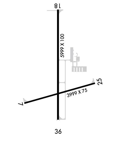
Runway Identifications
Runway Identification: 07/25Length: 3999 ft
Width: 75 ft
Surface: ASPHALT-GOOD CONDITION
Edge lights: Medium IntensityTreatment: NONE
| | Runway: 07 | | Runway: 25 |
| Mag heading: | 77° | Mag heading: | 257° |
| Rwy Slope: | -.03% Down | Rwy Slope: | .03% Up |
| Approach: | | Approach: | |
| Pattern: | Left Traffic | Pattern: | Left Traffic |
| Markings: | NONPRECISION INSTRUMENT | Markings: | NONPRECISION INSTRUMENT |
| Marking Condition: | GOOD | Marking Condition: | GOOD |
| Arresting Dev: | | Arresting Dev: | |
| Lat & Long: | N4120.8 W08909.6 | Lat. & Long.: | N4120.9 W08908.7 |
| Elev: | 651.0 ft. MSL | Elev: | 649.8 ft. MSL |
| TCH: | | TCH: | |
| Visual Glide Path: | | Visual Glide Path: | |
| Displaced Threshold: | No | Displaced Threshold: | No |
| Touchdown Zone: | YES | Touchdown Zone: | YES |
| Touchdown Elev.: | 651.1 feet | Touchdown Elev.: | 649.8 feet |
| Visual Glide Slope: | | Visual Glide Slope: | |
| RVR Equipment: | | RVR Equipment: | |
| RVV Equipment: | NO | RVV Equipment: | NO |
| Approach Lights: | | Approach Lights: | |
| REIL: | YES | REIL: | YES |
| Centerline Lights: | NO | Centerline Lights: | NO |
| Touchdown lights: | NO | Touchdown lights: | NO |
| Runway Category: | Runway with a Visual Approach | Runway Category: | Runway with a Visual Approach |
| Declared Distances: | | Declared Distances: | |
Runway Identification: 18/36Length: 5999 ft
Width: 100 ft
Surface: ASPHALT-GOOD CONDITION
Edge lights: Medium IntensityTreatment: NONE
| | Runway: 18 | | Runway: 36 |
| Mag heading: | 183° | Mag heading: | 3° |
| Rwy Slope: | -.28% Down | Rwy Slope: | .28% Up |
| Approach: | | Approach: | LOCALIZER |
| Pattern: | Left Traffic | Pattern: | Left Traffic |
| Markings: | NONPRECISION INSTRUMENT | Markings: | NONPRECISION INSTRUMENT |
| Marking Condition: | GOOD | Marking Condition: | GOOD |
| Arresting Dev: | | Arresting Dev: | |
| Lat & Long: | N4121.6 W08909.2 | Lat. & Long.: | N4120.6 W08909.2 |
| Elev: | 654.2 ft. MSL | Elev: | 637.5 ft. MSL |
| TCH: | | TCH: | |
| Visual Glide Path: | | Visual Glide Path: | |
| Displaced Threshold: | No | Displaced Threshold: | No |
| Touchdown Zone: | YES | Touchdown Zone: | YES |
| Touchdown Elev.: | 654.2 feet | Touchdown Elev.: | 649.8 feet |
| Visual Glide Slope: | | Visual Glide Slope: | |
| RVR Equipment: | | RVR Equipment: | |
| RVV Equipment: | NO | RVV Equipment: | NO |
| Approach Lights: | | Approach Lights: | ODALS - omnidirectional approach lighting system |
| REIL: | NO | REIL: | NO |
| Centerline Lights: | NO | Centerline Lights: | NO |
| Touchdown lights: | NO | Touchdown lights: | NO |
| Runway Category: | Runway with a Non-precision Approach having visibility minimums greater than 3/4 mile | Runway Category: | D |
| Declared Distances: | | Declared Distances: | |
| Obstructions: | POLE; WIRES AT SOUTH END OF RY ARE NOT THE CTLG OBSTN; APCH SLOPE IS 36:1 & MKD WITH ORANGE BALLS . | Obstructions: | |
| Marked: | NOT Marked/Lighted | Marked: | |
| Clearance slope: | 31:1 | Clearance slope: | 34:1 |
| Obstruction height: | 33 feet AGL | Obstruction height: | |
| Dist. from runway: | 1229 feet | Dist. from runway: | |
| Centerline offset: | 559 left of centerline | Centerline offset: | |
| Comments: | | Comments: | |

