Click here for more info on on SMS!

KVVS

JOSEPH A. HARDY CONNELLSVILLE
CONNELLSVILLE
PA
Time Zone: Eastern
Lat: N 3957.5
Long: W 07939.4
Elev: 1264
Var: +08
Longest Runway: 3833
AWOS: 133.32
CTAF: 122.8

FBO & Flight Services info for KVVS

FBOs: Update your Fuel Prices

  click here  
Providing high quality fuel and services to you and your customers, from Phillips 66.
Ph: 724-626-1610 Fax: 724-628-3081 Freq: 122.8Website-
                               
Service
Jet
100LL
SAF
MoGas
Fuel Avail: PRIST+ $0.05/gal. &w/volume Cash discount w/Jet A ONLY!
Full6.166.45    Caution: Fuel prices have not been updated in 32 days.
Last Update: 03/18/2024 10:56

Self  6.35    
Misc. Info: CASH DISCOUNTS AVAILABLE /Address: 988 SKY DR   LEMONT FURNACE, PA 15456

AWOSPh: 724-626-8745
-
Freq: 133.32  
If you are an FBO, call 1-203-262-1700 to update your info or email: FltPlan.Advertising@garmin.com
Advertise your FBO on FltPlan.com

Runway & Approach Info for KVVS
Rwy
Length
Land Dist**
Approach*
  Rwy
Length
Land Dist**
Approach*
05
3833x100  3833'          
LOCALIZER
 110.70 - 049°  
  
23
  3833x100  3833'          
 
14
2404x100  2404'          
 
  
32
  2404x100  2404'          
 
 * only ILS, LOC, LDA, and SDF approaches to a specific runway are shown
** For any Declared Landing Distance Available, please see A/FD or Approach plates
Runway Weight Capability (lbs.) Help
Runway IDSingle WheelDouble WheelDouble Tandem WheelDual Double Wheel
05/2312,500N/AN/AN/A
14/3212,500N/AN/AN/A
These numbers are Advisory and are not limits.   The Airport Manager should have more accurate Weight Limits
Approach Charts
Approaches    
Current Weather/Notams
Customs Information Send updates to Support@FltPlan.com
Customs Not Available
Database effective 04/18/2024
Airport Diagram of KVVS
Airport Diagram might not be current.

Facility Name: JOSEPH A HARDY CONNELLSVILLE
City Name: CONNELLSVILLE
County: FAYETTE
State abbrev: PA
State Name: PENNSYLVANIA
   
Ownership: PUBLICLY OWNED
Use: OPEN TO THE PUBLIC
Owner's Name: FAYETTE COUNTY AIRPORT AUTHORITY
Address: 988 SKY DRIVE
 LEMONT FURNACE, PA 15456
Owner's Phone: 724-628-2276
  
Manager's Name: JOHN NECKERAUER
Address: 988 SKY DRIVE
 LEMONT FURNACE, PA 15456
Phone: 724-628-2276; AFT HRS 412-916-6282.
   
FAA Region: EASTERN
FAA Field Office: HAR


Sunrise / Sunset times for JOSEPH A HARDY CONNELLSVILLE

DateSunriseSunset
04/18/24 Thursday6:3520:01
04/19/24 Friday6:3420:02
04/20/24 Saturday6:3220:03
04/21/24 Sunday6:3120:04
04/22/24 Monday6:3020:05
04/23/24 Tuesday6:2820:06
04/24/24 Wednesday6:2720:07
04/25/24 Thursday6:2620:08
04/26/24 Friday6:2420:09
04/27/24 Saturday6:2320:10
04/28/24 Sunday6:2220:11
04/29/24 Monday6:2020:12
04/30/24 Tuesday6:1920:13
05/01/24 Wednesday6:1820:14

Airport Facilities

Airport Attendance Schedule7 Days A Week 0800 - 1700
Airport Status OPERATIONAL (This Status can change at any time - please check NOTAMS)
Airport Lighting ScheduleACTVT REIL RWY 05; PAPI RWY 05, 23 & 14. MIRL RWY 05/23 & 14/32 - CTAF.
Airport Storage AvailableTie Downs, Hanger
Extra Services AvailableAir Ambulance, Aircraft Rental
Wind IndicatorYES - (lighted)
Control TowerNO
CTAF Frequency122.800
Unicom Frequency122.800
Rotating Beacon ColorWG
Segmented CircleYES
Landing FeeYES; LDG FEE FOR ALL ACFT OVER 6000 LBS GWT; WAIVED FOR FUEL PURCHASE.

Airport Inspection Data

Airport InspectedSTATE - performed by STATE AERONAUTICAL PERSONNEL
Inspection Date11/20/2023

Airport Services

Type of Fuel AvailableGrade 100LL, JET A (freeze point -40C); -10SELF SVC 100LL AVBL 24 HRS; CREDIT CARD ONLY.
Airframe Repair ServiceMAJOR
Power Plant Repair ServiceMAJOR

Geographic Data

LatitudeN3957.5
LongitudeW07939.4 (ESTIMATED)
Arpt Elevation1264ft (SURVEYED)
Magnetic Variation08W
5 miles SWof CONNELLSVILLE
Traffic Pattern Altitude
Sectional ChartCINCINNATI

Aircraft Data

Operations (Reported)YearlyAvg. Daily
General Aviation Transient 1150032
General Aviation Local 1464040
Air Taxi 450012
Commerical 00
Commuter 00
Military 200
Aircraft based on Field
General Aviation Singles 23
General Aviation Multi 2
Jet Aircraft 0
General Aviation Helicopters 0
Military Aircraft 0
Gliders 0
Ultralights 0

FAA Services

FSS on field NO
FSS tie-in ALTOONA
FSS Phone 1-800-WX-BRIEF
Who issues Notams AOO
Notam D service at airport YES
ARTCC Name CLEVELAND

Federal Status

Airport Certification
Aircraft Rescue & Firefighting IndexNone
Airport of EntryNo
Custom Landing RightsNo
Joint Civil/MilitaryNo
Military Landing rightsYES

Federal Agreements

NATIONAL PLAN OF INTEGRATED AIRPORT SYSTEMS (NPIAS)
GRANT AGREEMENTS UNDER FAAP/ADAP/AIP
SURPLUS PROPERTY AGREEMENT UNDER REGULATION 16-WAA
ASSURANCES PURSUANT TO TITLE VI, CIVIL RIGHTS ACT OF 1964

Remarks

RWY 23 HAS A 265 FT RELOCATED THR FOR TAXI ONLY. RWY 14 HAS A 315 FT RELOCATED THR FOR TAXI ONLY, RWY 32 HAS A 260 FT RELOCATED THR FOR TAXI ONLY.
DEER & BIRDS ON & INVOF ARPT.
TWY B CLSD TO ACFT WITH WINGSPAN MORE THAN 40 FT.
FOR CD CTC CLARKSBURG APCH AT 304-842-2011, WHEN APCH CLSD CTC CLEVELAND ARTCC AT 440-774-0226.
RWY 14/32: CLSD SS TO SR.
RWY 14/3 2 THLD & EDGE LGT OTS INDEF.
Airport Communications & Frequencies:
CTAF Frequency:
122.800
Unicom Frequency:
122.800
Remarks
  • APCH/DEP SVC PRVDD BY CLEVELAND ARTCC (ZOB) ON FREQS 124.4/327.1 (ALTOONA RCAG) WHEN CLARKSBURG APCH CTL CLSD.
  • CLARKSBURG Primary Approach Frequencies:  
    119.425
    284.65
    CLARKSBURG Primary Departure Frequencies:  
    119.425
    284.65
    Runway Identifications
    Runway Identification: 05/23
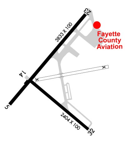
    Length: 3833 ft
    Width: 100 ft
    Surface: ASPHALT-FAIR CONDITION
    Edge lights: Medium Intensity

    Treatment: NONE

     Runway: 05   Runway: 23
    Mag heading: 49°Mag heading: 229°
    Rwy Slope: 1.17% UpRwy Slope: -1.17% Down
    Approach: LOCALIZERApproach:
    Pattern: Left TrafficPattern: Left Traffic
    Markings: NONPRECISION INSTRUMENTMarkings: BASIC
    Marking Condition: GOODMarking Condition: GOOD
    Arresting Dev: Arresting Dev:
    Lat & Long: N3957.4  W07939.7Lat. & Long.: N3957.9  W07939.2
    Elev: 1219.6 ft. MSLElev: 1264.4 ft. MSL
    TCH: 41 ft. AGLTCH: 20 ft. AGL
    Visual Glide Path: 3.00 degreesVisual Glide Path: 3.00 degrees
    Displaced Threshold: NoDisplaced Threshold: No
    Touchdown Zone: YESTouchdown Zone: YES
    Touchdown Elev.: 1254.0 feetTouchdown Elev.: 1264.4 feet
    Visual Glide Slope: 2-Light PAPI on LEFT side of RunwayVisual Glide Slope: 2-Light PAPI on RIGHT side of Runway
    RVR Equipment: RVR Equipment:
    RVV Equipment: NORVV Equipment: NO
    Approach Lights: Approach Lights:
    REIL: YESREIL: NO
    Centerline Lights: NOCenterline Lights: NO
    Touchdown lights: NOTouchdown lights: NO
    Runway Category: Runway with a Non-precision ApproachRunway Category: Runway with a Visual Approach
    Declared Distances: Declared Distances:
    Comments: RWY 05: 11 FT TREES, 166 FT BK FM RWY END, 103 FT RT; 7 FT TREES, 108 FT BK FM RWY END, 95 FT RT; 12 FT TREES 5 FT BK FM RWY, 102 FT LT; 11 FT TREES, 156 FT BK FM RWY END, 111 FT LT; 11 FT TREES 205 FT BK FM RWY END, 119 FT LT.Comments:
    Runway Identification: 14/32
    Length: 2404 ft
    Width: 100 ft
    Surface: ASPHALT-FAIR CONDITION
    Edge lights: Medium Intensity

    Treatment: NONE

     Runway: 14   Runway: 32
    Mag heading: 139°Mag heading: 319°
    Rwy Slope: .37% UpRwy Slope: -.37% Down
    Approach: Approach:
    Pattern: Left TrafficPattern: Left Traffic
    Markings: BASICMarkings: BASIC
    Marking Condition: GOODMarking Condition: GOOD
    Arresting Dev: Arresting Dev:
    Lat & Long: N3957.5  W07939.6Lat. & Long.: N3957.3  W07939.2
    Elev: 1227.5 ft. MSLElev: 1236.4 ft. MSL
    TCH: 27 ft. AGLTCH:
    Visual Glide Path: 3.00 degreesVisual Glide Path:
    Displaced Threshold: NoDisplaced Threshold: No
    Touchdown Zone: YESTouchdown Zone: YES
    Touchdown Elev.: 1236.4 feetTouchdown Elev.: 1236.4 feet
    Visual Glide Slope: 2-Light PAPI on LEFT side of Runway; PAPI OTS INDEF.Visual Glide Slope:
    RVR Equipment: RVR Equipment:
    RVV Equipment: NORVV Equipment: NO
    Approach Lights: Approach Lights:
    REIL: NOREIL: NO
    Centerline Lights: NOCenterline Lights: NO
    Touchdown lights: NOTouchdown lights: NO
    Runway Category: Runway with a Visual ApproachRunway Category: Runway with a Visual Approach
    Declared Distances: Declared Distances:
    Obstructions: TREESObstructions: TREES
    Marked: NOT Marked/LightedMarked: NOT Marked/Lighted
    Clearance slope: 17:1Clearance slope: 7:1
    Obstruction height: 47 feet AGLObstruction height: 12 feet AGL
    Dist. from runway: 999 feetDist. from runway: 285 feet
    Centerline offset: 128 right of centerlineCenterline offset: 93 feet left of centerline
    Comments: RWY 14: 31 FT TREES, 805 FT BK FM RWY END, 92 FT RT; 24 FT TREES 395 FT BK FM RWY END 91 FT RT.Comments:
    C:7/P: