Current Weather/Notams (Metars, TAFs, Notams, NWS Forecast, PIREPS, and nearby weather)
Customs Information Send updates to Support@FltPlan.com
Customs Not Available
Database effective 05/16/2024
Airport Diagram might not be current.
|
| Facility Name: | MILLER FLD |
| City Name: | VALENTINE |
| County: | CHERRY |
| State abbrev: | NE |
| State Name: | NEBRASKA |
| | |
| Ownership: | PUBLICLY OWNED |
| Use: | OPEN TO THE PUBLIC |
| Owner's Name: | CITY OF VALENTINE |
| Address: | P.O. BOX 177, 323 NORTH MAIN |
| | VALENTINE, NE 69201-0177 |
| Owner's Phone: | 402-376-2323; CITY HALL PHONE NUMBER. |
| | |
| Manager's Name: | ROBERT KILMER |
| Address: | 100 SOUTH STREET |
| | VALENTINE, NE 69201-9501 |
| Phone: | 402-376-1611 |
| | |
| FAA Region: | CENTRAL |
| FAA Field Office: | NONE |
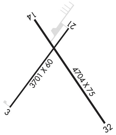
Runway Identifications
Runway Identification: 03/21Length: 3701 ft
Width: 60 ft
Surface: CONCRETE
Edge lights: Medium IntensityTreatment: NONE
| | Runway: 03 | | Runway: 21 |
| Mag heading: | 28° | Mag heading: | 208° |
| Rwy Slope: | -.26% Down | Rwy Slope: | .26% Up |
| Approach: | | Approach: | |
| Pattern: | Left Traffic | Pattern: | Left Traffic |
| Markings: | NONPRECISION INSTRUMENT | Markings: | NONPRECISION INSTRUMENT |
| Marking Condition: | GOOD | Marking Condition: | GOOD |
| Arresting Dev: | | Arresting Dev: | |
| Lat & Long: | N4251.2 W10033.3 | Lat. & Long.: | N4251.7 W10032.8 |
| Elev: | 2595.4 ft. MSL | Elev: | 2585.9 ft. MSL |
| TCH: | 39 ft. AGL | TCH: | 45 ft. AGL |
| Visual Glide Path: | 3.00 degrees | Visual Glide Path: | 3.00 degrees |
| Displaced Threshold: | No | Displaced Threshold: | 299 feet |
| Touchdown Zone: | YES | Touchdown Zone: | YES |
| Touchdown Elev.: | 2595.4 feet | Touchdown Elev.: | 2595.2 feet |
| Visual Glide Slope: | 2-Light PAPI on LEFT side of Runway | Visual Glide Slope: | 2-Light PAPI on LEFT side of Runway |
| RVR Equipment: | | RVR Equipment: | |
| RVV Equipment: | NO | RVV Equipment: | NO |
| Approach Lights: | | Approach Lights: | |
| REIL: | NO | REIL: | NO |
| Centerline Lights: | NO | Centerline Lights: | NO |
| Touchdown lights: | NO | Touchdown lights: | NO |
| Runway Category: | Runway with a Non-precision Approach | Runway Category: | Runway with a Non-precision Approach |
| Declared Distances: | | Declared Distances: | |
Runway Identification: 14/32Length: 4704 ft
Width: 75 ft
Surface: CONCRETE
Edge lights: Medium IntensityTreatment: NONE
| | Runway: 14 | | Runway: 32 |
| Mag heading: | 137° | Mag heading: | 317° |
| Rwy Slope: | -.10% Down | Rwy Slope: | .10% Up |
| Approach: | | Approach: | |
| Pattern: | Left Traffic | Pattern: | Left Traffic |
| Markings: | NONPRECISION INSTRUMENT | Markings: | NONPRECISION INSTRUMENT |
| Marking Condition: | GOOD | Marking Condition: | GOOD |
| Arresting Dev: | | Arresting Dev: | |
| Lat & Long: | N4251.7 W10033.1 | Lat. & Long.: | N4251.1 W10032.5 |
| Elev: | 2587.4 ft. MSL | Elev: | 2582.7 ft. MSL |
| TCH: | 37 ft. AGL | TCH: | 43 ft. AGL |
| Visual Glide Path: | 3.00 degrees | Visual Glide Path: | 3.00 degrees |
| Displaced Threshold: | 384 feet | Displaced Threshold: | No |
| Touchdown Zone: | YES | Touchdown Zone: | YES |
| Touchdown Elev.: | 2588.9 feet | Touchdown Elev.: | 2588.9 feet |
| Visual Glide Slope: | 2-Light PAPI on LEFT side of Runway | Visual Glide Slope: | 2-Light PAPI on LEFT side of Runway |
| RVR Equipment: | | RVR Equipment: | |
| RVV Equipment: | NO | RVV Equipment: | NO |
| Approach Lights: | | Approach Lights: | |
| REIL: | NO | REIL: | YES |
| Centerline Lights: | NO | Centerline Lights: | NO |
| Touchdown lights: | NO | Touchdown lights: | NO |
| Runway Category: | Runway with a Non-precision Approach having visibility minimums greater than 3/4 mile | Runway Category: | Runway with a Non-precision Approach having visibility minimums greater than 3/4 mile |
| Declared Distances: | | Declared Distances: | |
| Obstructions: | TREES | Obstructions: | FENCE |
| Marked: | NOT Marked/Lighted | Marked: | NOT Marked/Lighted |
| Clearance slope: | 8:1; RWY 14 APCH SLOPE 31:1 DUE TO 24 FT FIR TREES 807 FT FROM DTHR. | Clearance slope: | 21:1; RWY 32 234' LT @ 9', MEASURED |
| Obstruction height: | 26 feet AGL | Obstruction height: | 9 feet AGL; -4.4' @ 60' RT; +1.4' ON CENTERLINE; +8.5' @ 234' LT |
| Dist. from runway: | 423 feet | Dist. from runway: | 395 feet; SURVEYED |
| Centerline offset: | 214 right of centerline | Centerline offset: | |
| Comments: | | Comments: | |

