Current Weather/Notams (Metars, TAFs, Notams, NWS Forecast, PIREPS, and nearby weather)
Customs Information Send updates to Support@FltPlan.com
Customs Not Available
Database effective 05/16/2024
Airport Diagram might not be current.
|
| Facility Name: | VINTON VETERANS MEML AIRPARK |
| City Name: | VINTON |
| County: | BENTON |
| State abbrev: | IA |
| State Name: | IOWA |
| | |
| Ownership: | PUBLICLY OWNED |
| Use: | OPEN TO THE PUBLIC |
| Owner's Name: | CITY OF VINTON |
| Address: | PO BOX 529 |
| | VINTON, IA 52349 |
| Owner's Phone: | 319-472-4707 |
| | |
| Manager's Name: | TOM BOECKMANN; CHAIRMAN, ARPT CMSN. MGR NOT AT FIELD. |
| Address: | CITY HALL - P.O. BOX 529 |
| | VINTON, IA 52349 |
| Phone: | 319-310-4724; ARPT PHONE 319-472-2758. |
| | |
| FAA Region: | CENTRAL |
| FAA Field Office: | NONE |
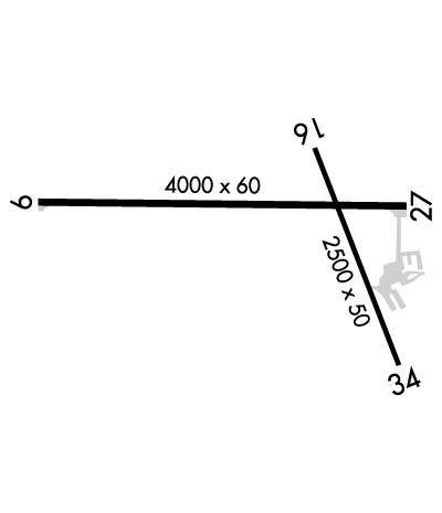
Runway Identifications
Runway Identification: 09/27Length: 4000 ft
Width: 60 ft
Surface: CONCRETE-FAIR CONDITION
Edge lights: Medium IntensityTreatment: NONE
Weight: PCN 6 /R/D/W/T
| | Runway: 09 | | Runway: 27 |
| Mag heading: | 91° | Mag heading: | 272° |
| Rwy Slope: | .36% Up | Rwy Slope: | -.36% Down |
| Approach: | | Approach: | |
| Pattern: | Left Traffic | Pattern: | Left Traffic |
| Markings: | NONPRECISION INSTRUMENT | Markings: | NONPRECISION INSTRUMENT |
| Marking Condition: | GOOD | Marking Condition: | GOOD |
| Arresting Dev: | | Arresting Dev: | |
| Lat & Long: | N4213.2 W09202.1 | Lat. & Long.: | N4213.1 W09201.2 |
| Elev: | 824.0 ft. MSL | Elev: | 838.2 ft. MSL |
| TCH: | 45 ft. AGL | TCH: | 32 ft. AGL |
| Visual Glide Path: | 4.00 degrees | Visual Glide Path: | 3.00 degrees |
| Displaced Threshold: | No | Displaced Threshold: | No |
| Touchdown Zone: | YES | Touchdown Zone: | YES |
| Touchdown Elev.: | 835.7 feet | Touchdown Elev.: | 839.2 feet |
| Visual Glide Slope: | 2-Light PAPI on LEFT side of Runway | Visual Glide Slope: | 2-Light PAPI on LEFT side of Runway |
| RVR Equipment: | | RVR Equipment: | |
| RVV Equipment: | NO | RVV Equipment: | NO |
| Approach Lights: | | Approach Lights: | |
| REIL: | YES | REIL: | YES |
| Centerline Lights: | NO | Centerline Lights: | NO |
| Touchdown lights: | NO | Touchdown lights: | NO |
| Runway Category: | Runway with a Non-precision Approach | Runway Category: | Runway with a Non-precision Approach |
| Declared Distances: | | Declared Distances: | |
| Obstructions: | TREE | Obstructions: | TREE |
| Marked: | NOT Marked/Lighted | Marked: | NOT Marked/Lighted |
| Clearance slope: | 23:1 | Clearance slope: | 21:1 |
| Obstruction height: | 53 feet AGL | Obstruction height: | 45 feet AGL |
| Dist. from runway: | 1451 feet | Dist. from runway: | 1186 feet |
| Centerline offset: | 141 left of centerline | Centerline offset: | 178 feet left of centerline |
| Comments: | | Comments: | |
Runway Identification: 16/34Length: 2500 ft
Width: 50 ft
Surface: ASPHALT-GOOD CONDITION
Edge lights: Treatment: NONE
Weight: PCN 3 /F/D/X/T
| | Runway: 16 | | Runway: 34 |
| Mag heading: | 160° | Mag heading: | 340° |
| Rwy Slope: | .19% Up | Rwy Slope: | -.19% Down |
| Approach: | | Approach: | |
| Pattern: | Left Traffic | Pattern: | Left Traffic |
| Markings: | BASIC | Markings: | BASIC |
| Marking Condition: | GOOD | Marking Condition: | GOOD |
| Arresting Dev: | | Arresting Dev: | |
| Lat & Long: | N4213.2 W09201.5 | Lat. & Long.: | N4212.9 W09201.3 |
| Elev: | 833.4 ft. MSL | Elev: | 838.1 ft. MSL |
| TCH: | | TCH: | |
| Visual Glide Path: | | Visual Glide Path: | |
| Displaced Threshold: | No | Displaced Threshold: | 190 feet |
| Touchdown Zone: | YES | Touchdown Zone: | YES |
| Touchdown Elev.: | 839.0 feet | Touchdown Elev.: | 839.0 feet |
| Visual Glide Slope: | | Visual Glide Slope: | |
| RVR Equipment: | | RVR Equipment: | |
| RVV Equipment: | NO | RVV Equipment: | NO |
| Approach Lights: | | Approach Lights: | |
| REIL: | NO | REIL: | NO |
| Centerline Lights: | NO | Centerline Lights: | NO |
| Touchdown lights: | NO | Touchdown lights: | NO |
| Runway Category: | Runway with a Visual Approach | Runway Category: | Runway with a Visual Approach |
| Declared Distances: | | Declared Distances: | |
| Obstructions: | | Obstructions: | TREES |
| Marked: | | Marked: | NOT Marked/Lighted |
| Clearance slope: | 50:1 | Clearance slope: | 7:1; RWY 34 APCH 18:1 AT DTHR. |
| Obstruction height: | | Obstruction height: | 36 feet AGL |
| Dist. from runway: | | Dist. from runway: | 484 feet |
| Centerline offset: | | Centerline offset: | 99 feet right of centerline |
| Comments: | | Comments: | |

