Click here for more info on on SMS!

KVTA

NEWARK-HEATH
NEWARK
OH
Time Zone: Eastern
Lat: N 4001.5
Long: W 08227.7
Elev: 884
Var: +06
Longest Runway: 4649
Clr Del: 125.175
AWOS: 121.12
CTAF: 122.7

FBO & Flight Services info for KVTA

FBOs: Update your Fuel Prices
Welcome to Newark-Heath Airport! We offer many services to the general public and the aviation community including hangar rental, full service refueling (Jet-A and 100LL), air craft rental, aircraft training and an outstanding maintenance shop. Our normal operating hours are 0800-1800 EST and feel free to contact us about further services or general aviation travel arrangements to the area.
Ph: 740-522-6968 Fax: 740-522-2427 Freq: 122.7WebsiteE-Mail
                                  
Service
Jet
100LL
SAF
MoGas
Fuel Avail: PRIST PREMIXED., ALL TXS IN
Full6.456.65    Last Update: 04/15/2024 12:35

Self        
Misc. Info: Address: 530 HEATH RD,   HEATH, OH 43056

ASOSPh: 740-522-1066
-
Freq: 121.12  
If you are an FBO, call 1-203-262-1700 to update your info or email: FltPlan.Advertising@garmin.com
Advertise your FBO on FltPlan.com

Runway & Approach Info for KVTA
Rwy
Length
Land Dist**
Approach*
  Rwy
Length
Land Dist**
Approach*
09
4649x75  4192'          
LOCALIZER
 110.90 - 093°  
  
27
  4649x75  4649'          
 
 * only ILS, LOC, LDA, and SDF approaches to a specific runway are shown
** For any Declared Landing Distance Available, please see A/FD or Approach plates
Runway Weight Capability (lbs.) Help
Runway IDSingle WheelDouble WheelDouble Tandem WheelDual Double Wheel
09/2730,000N/AN/AN/A
These numbers are Advisory and are not limits.   The Airport Manager should have more accurate Weight Limits
Approach Charts
Approaches    
Current Weather/Notams
Customs Information Send updates to Support@FltPlan.com
Customs Not Available
Database effective 04/18/2024
Airport Diagram of KVTA
Airport Diagram might not be current.

Facility Name: NEWARK-HEATH
City Name: NEWARK
County: LICKING
State abbrev: OH
State Name: OHIO
   
Ownership: PUBLICLY OWNED
Use: OPEN TO THE PUBLIC
Owner's Name: LICKING CO RGNL ARPT AUTH
Address: 530 HEATH RD
 HEATH, OH 43056-1134
Owner's Phone: 740-522-6968
  
Manager's Name: HAROLD WARE
Address: 530 HEATH RD
 HEATH, OH 43056-1134
Phone: 740-522-6968; ADNL CTC: 740-929-4205 OR AVIATIONWORKSINC@GMAIL.COM
   
FAA Region: GREAT LAKES
FAA Field Office: DET
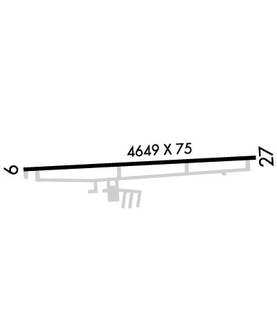

Sunrise / Sunset times for NEWARK-HEATH

DateSunriseSunset
04/17/24 Wednesday6:4820:11
04/18/24 Thursday6:4620:12
04/19/24 Friday6:4520:13
04/20/24 Saturday6:4420:14
04/21/24 Sunday6:4220:15
04/22/24 Monday6:4120:16
04/23/24 Tuesday6:3920:17
04/24/24 Wednesday6:3820:18
04/25/24 Thursday6:3720:19
04/26/24 Friday6:3520:20
04/27/24 Saturday6:3420:21
04/28/24 Sunday6:3320:22
04/29/24 Monday6:3120:23
04/30/24 Tuesday6:3020:24

Airport Facilities

Airport Attendance ScheduleAPR-OCT 7 Days A Week 0730-1930, NOV-MAR 7 Days A Week 0730-DUSK
Airport Status OPERATIONAL (This Status can change at any time - please check NOTAMS)
Airport Lighting ScheduleINCR INTST REIL RWY 09 & 27; MIRL RWY 09/27 - 123.3. LGTS PRESET LOW INTST.
Airport Storage AvailableHanger
Extra Services AvailableCrop Dusting, Flight Instruction, Aircraft Rental
Wind IndicatorYES - (lighted)
Control TowerNO
CTAF Frequency122.700
Unicom Frequency122.700
Rotating Beacon ColorWG
Segmented CircleNO
Landing FeeNO

Airport Inspection Data

Airport InspectedSTATE - performed by STATE AERONAUTICAL PERSONNEL
Inspection Date12/21/2022

Airport Services

Type of Fuel AvailableGrade 100LL, JET A-1 (freeze point -50C), JET A-1 (icing inhibitor, freeze point -50C); -10100LL AVBL 24/7 WITH CREDIT CARD.
Airframe Repair ServiceMAJOR
Power Plant Repair ServiceMAJOR

Geographic Data

LatitudeN4001.5
LongitudeW08227.7 (ESTIMATED)
Arpt Elevation883ft (SURVEYED)
Magnetic Variation06W
3 miles SWof NEWARK
Traffic Pattern Altitude1016
Sectional ChartDETROIT

Aircraft Data

Operations (Reported)YearlyAvg. Daily
General Aviation Transient 447812
General Aviation Local 455212
Air Taxi 800
Commerical 00
Commuter 00
Military 1000
Aircraft based on Field
General Aviation Singles 63
General Aviation Multi 6
Jet Aircraft 1
General Aviation Helicopters 0
Military Aircraft 0
Gliders 0
Ultralights 0

FAA Services

FSS on field NO
FSS tie-in DAYTON
FSS Phone 1-800-WX-BRIEF
Who issues Notams VTA
Notam D service at airport YES
ARTCC Name INDIANAPOLIS

Federal Status

Airport Certification
Aircraft Rescue & Firefighting IndexNone
Airport of EntryNo
Custom Landing RightsNo
Joint Civil/MilitaryNo
Military Landing rightsNo

Federal Agreements

NATIONAL PLAN OF INTEGRATED AIRPORT SYSTEMS (NPIAS)
GRANT AGREEMENTS UNDER FAAP/ADAP/AIP
ASSURANCES PURSUANT TO TITLE VI, CIVIL RIGHTS ACT OF 1964

Remarks

OCNL DEER, BIRDS, & OTR WILDLIFE ON & INVOF ARPT.
Airport Communications & Frequencies:
Clearance Delivery Frequencies:
125.175
CTAF Frequency:
122.700
Unicom Frequency:
122.700
COLUMBUS Primary Approach Frequencies:  
125.95
317.775
COLUMBUS Primary Departure Frequencies:  
125.95
317.775
Runway Identifications
Runway Identification: 09/27
Length: 4649 ft
Width: 75 ft
Surface: ASPHALT-GOOD CONDITION
Edge lights: Medium Intensity

Treatment: NONE

 Runway: 09   Runway: 27
Mag heading: 93°Mag heading: 273°
Rwy Slope: -.27% DownRwy Slope: .27% Up
Approach: LOCALIZERApproach:
Pattern: Left TrafficPattern: Left Traffic
Markings: NONPRECISION INSTRUMENTMarkings: NONPRECISION INSTRUMENT
Marking Condition: GOODMarking Condition: GOOD
Arresting Dev: Arresting Dev:
Lat & Long: N4001.5  W08228.2Lat. & Long.: N4001.5  W08227.2
Elev: 882.4 ft. MSLElev: 869.8 ft. MSL
TCH: 28 ft. AGLTCH: 20 ft. AGL
Visual Glide Path: 3.25 degreesVisual Glide Path: 3.25 degrees
Displaced Threshold: 457 feetDisplaced Threshold: No
Touchdown Zone: YESTouchdown Zone: YES
Touchdown Elev.: 883.5 feetTouchdown Elev.: 878.5 feet
Visual Glide Slope: 4-Light PAPI on LEFT side of RunwayVisual Glide Slope: 4-Light PAPI on RIGHT side of Runway
RVR Equipment: RVR Equipment:
RVV Equipment: NORVV Equipment: NO
Approach Lights: Approach Lights:
REIL: YESREIL: YES
Centerline Lights: NOCenterline Lights: NO
Touchdown lights: NOTouchdown lights: NO
Runway Category: Runway with a Non-precision ApproachRunway Category: Runway with a Non-precision Approach
Declared Distances: Declared Distances:
Obstructions: ROADObstructions: BERM
Marked: NOT Marked/LightedMarked: NOT Marked/Lighted
Clearance slope: APCH RATIO 18:1 OVR +15 FT ROAD, 279 FT DIST, 266 FT R.Clearance slope:
Obstruction height: 15 feet AGLObstruction height: 4 feet AGL
Dist. from runway: 201 feetDist. from runway: 201 feet
Centerline offset: 220 right of centerlineCenterline offset: 155 feet right of centerline
Comments: +15 FT ROAD, 0 FT DIST, 200 FT R; +11 FT FENCE, 0-200 FT DIST, 129-198 FT R.Comments: +3-5 FT BERM, 0-200 FT DIST, 155 FT L/R.
C:4/P: