KVNC

VENICE MUNI
VENICE
FL
Time Zone: Eastern
Lat: N 2704.3
Long: W 08226.4
Elev: 18
Var: +05
Longest Runway: 5640
Clr Del: 118.075
AWOS: 119.27
CTAF: 122.72

FBO & Flight Services info for KVNC

FBOs: Update your Fuel Prices

  click here  
Professional Avionics Installation, Service and Repair. Our facilities at KVNC are equipped to handle full-service aircraft maintenance and advanced avionics installations. Venice serves as our company headquarters, where we own and operate three hangars totaling 24,000 SF. Offices located in the last hangar accessible from the road on the West side of the airport.
Ph: 888-289-0997 Fax: 941-360-6878
-
WebsiteE-Mail
                   
Service
Jet
100LL
SAF
MoGas
Fuel Avail: ~~
Full        Last Update: 04/19/2024 00:01:44

Self        
Misc. Info: Toll free 1-888-289-0997 Ext. 105Address: 120 AIRPORT AVENUE WEST,   VENICE, FL 34285

SUNCOAST AIR CTRPh: 941-485-1799 Fax: 941-485-1699 Freq: 131.30
Service
Jet
100LL
SAF
MoGas
Fuel Avail: FSII+$0.10/gal 0700-1900 7 days CALL FOR HOLIDAY HOURS
Full7.247.37    Last Update: 04/16/2024 09:43  
Self        
 Address: 400 AIRPORT AVE E   VENICE, FL 34285
FLORIDA FLIGHT MTPh: 941-484-3771 Fax: 941-483-9022
-
AWOSPh: 941-486-2718
-
Freq: 119.27  
If you are an FBO, call 1-203-262-1700 to update your info or email: FltPlan.Advertising@garmin.com
Advertise your FBO on FltPlan.com

Runway & Approach Info for KVNC
Rwy
Length
Land Dist**
Approach*
  Rwy
Length
Land Dist**
Approach*
05
5000x150  5000'          
 
  
23
  5000x150  4537'          
 
13
5640x150  5001'          
 
  
31
  5640x150  5001'          
 
 * only ILS, LOC, LDA, and SDF approaches to a specific runway are shown
** For any Declared Landing Distance Available, please see A/FD or Approach plates
Runway Weight Capability (lbs.) Help
Runway IDSingle WheelDouble WheelDouble Tandem WheelDual Double Wheel
05/2375,000108,000N/AN/A
13/3175,000108,000N/AN/A
These numbers are Advisory and are not limits.   The Airport Manager should have more accurate Weight Limits
Approach Charts
Approaches    
Current Weather/Notams
Customs Information Send updates to Support@FltPlan.com
Customs Not Available
Database effective 04/18/2024
Airport Diagram of KVNC
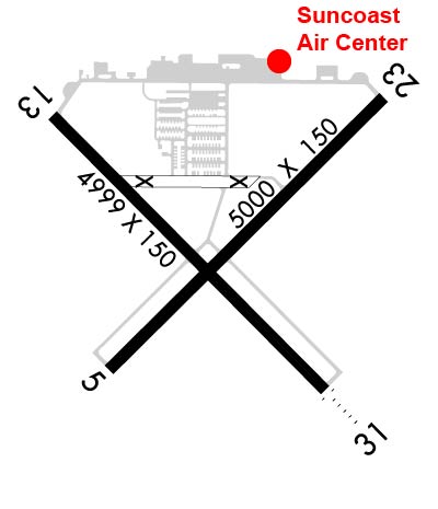
Airport Diagram might not be current.

Facility Name: VENICE MUNI
City Name: VENICE
County: SARASOTA
State abbrev: FL
State Name: FLORIDA
   
Ownership: PUBLICLY OWNED
Use: OPEN TO THE PUBLIC
Owner's Name: CITY OF VENICE
Address: 401 WEST VENICE AVE
 VENICE, FL 34285
Owner's Phone: 941-486-2626
  
Manager's Name: MARK J. CERVASIO; MCERVASIO@VENICEGOV.COM
Address: 150 EAST AIRPORT AVE
 VENICE, FL 34285
Phone: 941-486-2711
   
FAA Region: SOUTHERN
FAA Field Office: ORL


Sunrise / Sunset times for VENICE MUNI

DateSunriseSunset
04/18/24 Thursday7:0219:56
04/19/24 Friday7:0119:57
04/20/24 Saturday7:0019:57
04/21/24 Sunday6:5919:58
04/22/24 Monday6:5819:58
04/23/24 Tuesday6:5719:59
04/24/24 Wednesday6:5619:59
04/25/24 Thursday6:5620:00
04/26/24 Friday6:5520:01
04/27/24 Saturday6:5420:01
04/28/24 Sunday6:5320:02
04/29/24 Monday6:5220:02
04/30/24 Tuesday6:5120:03
05/01/24 Wednesday6:5120:03

Airport Facilities

Airport Attendance Schedule7 Days A Week 0700-1900
Airport Status OPERATIONAL (This Status can change at any time - please check NOTAMS)
Airport Lighting ScheduleACTVT REIL RWY 5, 23, & 13; MIRL RWY 5/23, 13/31 - CTAF.
Airport Storage AvailableTie Downs, Hanger
Extra Services AvailableAvionics, Charter, Flight Instruction, Aircraft Rental, Aircraft Sales
Wind IndicatorYES - (lighted)
Control TowerNO
CTAF Frequency122.725
Unicom Frequency122.725
Rotating Beacon ColorWG
Segmented CircleY-L
Landing FeeNO

Airport Inspection Data

Airport InspectedSTATE - performed by STATE AERONAUTICAL PERSONNEL
Inspection Date10/23/2023

Airport Services

Type of Fuel AvailableGrade 100LL, JET A (freeze point -40C)
Airframe Repair ServiceMAJOR
Power Plant Repair ServiceMAJOR

Geographic Data

LatitudeN2704.3
LongitudeW08226.4 (ESTIMATED)
Arpt Elevation18ft (SURVEYED)
Magnetic Variation05W
2 miles Sof VENICE
Traffic Pattern Altitude
Sectional ChartMIAMI

Aircraft Data

Operations (Reported)YearlyAvg. Daily
General Aviation Transient 2881679
General Aviation Local 3201888
Air Taxi 00
Commerical 00
Commuter 00
Military 00
Aircraft based on Field
General Aviation Singles 227
General Aviation Multi 30
Jet Aircraft 9
General Aviation Helicopters 7
Military Aircraft 0
Gliders 1
Ultralights 0

FAA Services

FSS on field NO
FSS tie-in SAINT PETERSBURG
FSS Phone 1-800-WX-BRIEF
Who issues Notams PIE
Notam D service at airport YES
ARTCC Name MIAMI

Federal Status

Airport Certification
Aircraft Rescue & Firefighting IndexNone
Airport of EntryNo
Custom Landing RightsNo
Joint Civil/MilitaryNo
Military Landing rightsYES

Federal Agreements

NATIONAL PLAN OF INTEGRATED AIRPORT SYSTEMS (NPIAS)
GRANT AGREEMENTS UNDER FAAP/ADAP/AIP
SURPLUS PROPERTY AGREEMENT UNDER PUBLIC LAW 289
SURPLUS PROPERTY AGREEMENT UNDER REGULATION 16-WAA
ASSURANCES PURSUANT TO TITLE VI, CIVIL RIGHTS ACT OF 1964

Remarks

SFC OF PERIMETER TWYS CRACKING, SOME SETTLEMENT.
NOISE ABATEMENT PROCEDURES IN EFFECT, CALL AMGR 941-486-2711.
ARPT SFC CONDS NOT RPRTD.
FOR CD CTC TAMPA APCH AT 813-878-2528
ARPT HAS EXTENSIVE FLIGHT TRAINING.
BIRD AND WILDLIFE ON AND INVOF THE ARPT.
PAEW ADJ TO ALL RYS AND TWYS DURG DALGT HRS.
PPR FOR ACFT EXCEEDING RY WEIGHT BEARING CAPACITY.
PARASAILING ACTIVITY WEST THE ARPT ALONG BEACH.
RY 23 IS CALM WIND RY.
RWY 05 RWY 05/23 PREF APCH.
RWY 23 PREF DEP CALM WIND RWY.
Airport Communications & Frequencies:
Clearance Delivery Frequencies:
118.075
CTAF Frequency:
122.725
Unicom Frequency:
122.725
TAMPA Primary Approach Frequencies:  
119.65
353.575
Part-time Approach Frequencies:  
124.95
TAMPA Primary Departure Frequencies:  
119.65
353.575
Part-time Departure Frequencies:  
124.95
Runway Identifications
Runway Identification: 05/23
Length: 5000 ft
Width: 150 ft
Surface: ASPHALT-GOOD CONDITION
Edge lights: Medium Intensity

Treatment: NONE
Weight: PCN 26 /F/A/X/T

 Runway: 05   Runway: 23
Mag heading: 50°Mag heading: 230°
Rwy Slope: .10% UpRwy Slope: -.10% Down
Approach: Approach:
Pattern: Left TrafficPattern: Left Traffic
Markings: NONPRECISION INSTRUMENTMarkings: NONPRECISION INSTRUMENT
Marking Condition: GOODMarking Condition: GOOD
Arresting Dev: Arresting Dev:
Lat & Long: N2704.0  W08226.7Lat. & Long.: N2704.6  W08226.0
Elev: 12.4 ft. MSLElev: 17.4 ft. MSL
TCH: 43 ft. AGLTCH: 48 ft. AGL
Visual Glide Path: 3.00 degreesVisual Glide Path: 3.00 degrees
Displaced Threshold: NoDisplaced Threshold: 463 feet
Touchdown Zone: YESTouchdown Zone: YES
Touchdown Elev.: 17.7 feetTouchdown Elev.: 18.1 feet
Visual Glide Slope: 2-Light PAPI on LEFT side of RunwayVisual Glide Slope: 2-Light PAPI on LEFT side of Runway
RVR Equipment: RVR Equipment:
RVV Equipment: NORVV Equipment: NO
Approach Lights: Approach Lights:
REIL: YESREIL: YES
Centerline Lights: NOCenterline Lights: NO
Touchdown lights: NOTouchdown lights: NO
Runway Category: Runway with a Non-precision Approach having visibility minimums greater than 3/4 mileRunway Category: Runway with a Non-precision Approach having visibility minimums greater than 3/4 mile
Declared Distances: Declared Distances: TORA:5000' TODA:5000' ASDA:4840' LDA:4377'
Obstructions: TREESObstructions: BRDG
Marked: NOT Marked/LightedMarked: LIGHTED
Clearance slope: 50:1Clearance slope: 18:1; RWY 23 APCH RATIO 30:1 TO DTHR.
Obstruction height: 14 feet AGLObstruction height: 55 feet AGL
Dist. from runway: 865 feetDist. from runway: 1190 feet
Centerline offset: 225 left of centerlineCenterline offset: 90 feet left of centerline
Comments: Comments:
Runway Identification: 13/31
Length: 5640 ft
Width: 150 ft
Surface: ASPHALT-GOOD CONDITION
Edge lights: Medium Intensity

Treatment: NONE
Weight: PCN 26 /F/A/X/T

 Runway: 13   Runway: 31
Mag heading: 140°Mag heading: 320°
Rwy Slope: .02% UpRwy Slope: -.02% Down
Approach: Approach:
Pattern: Right TrafficPattern: Left Traffic
Markings: NONPRECISION INSTRUMENTMarkings: NONPRECISION INSTRUMENT
Marking Condition: FAIRMarking Condition: FAIR
Arresting Dev: Arresting Dev:
Lat & Long: N2704.6  W08226.8Lat. & Long.: N2703.9  W08226.1
Elev: 14.9 ft. MSLElev: 16.3 ft. MSL
TCH: 46 ft. AGLTCH: 40 ft. AGL
Visual Glide Path: 3.00 degreesVisual Glide Path: 3.00 degrees
Displaced Threshold: 639 feetDisplaced Threshold: 639 feet
Touchdown Zone: YESTouchdown Zone: YES
Touchdown Elev.: 16.5 feetTouchdown Elev.: 16.5 feet
Visual Glide Slope: 4-Light PAPI on LEFT side of RunwayVisual Glide Slope: 4-Light PAPI on LEFT side of Runway
RVR Equipment: RVR Equipment:
RVV Equipment: NORVV Equipment: NO
Approach Lights: Approach Lights:
REIL: YESREIL: YES
Centerline Lights: NOCenterline Lights: NO
Touchdown lights: NOTouchdown lights: NO
Runway Category: Runway with a Non-precision Approach having visibility minimums greater than 3/4 mileRunway Category: Runway with a Non-precision Approach having visibility minimums greater than 3/4 mile
Declared Distances: TORA:5000' TODA:5000' ASDA:5000' LDA:5000'Declared Distances: TORA:5000' TODA:5000' ASDA:5000' LDA:5000'
Obstructions: TREESObstructions: TREE
Marked: NOT Marked/LightedMarked: NOT Marked/Lighted
Clearance slope: 28:1; RWY 13 APCH SLOPE 45:1 TO DTHR.Clearance slope: 15:1; RWY 31 APCH SLOPE 34:1 TO DTHR.
Obstruction height: 34 feet AGLObstruction height: 45 feet AGL
Dist. from runway: 1155 feetDist. from runway: 885 feet
Centerline offset: 250 right of centerlineCenterline offset: 110 feet right of centerline
Comments: Comments:
C:51/P: