Current Weather/Notams (Metars, TAFs, Notams, NWS Forecast, PIREPS, and nearby weather)
Customs Information Send updates to Support@FltPlan.com
Customs Not Available
Database effective 05/16/2024
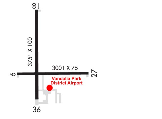
Airport Diagram might not be current. Facility Name: VANDALIA MUNI City Name: VANDALIA County: FAYETTE State abbrev: IL State Name: ILLINOIS Ownership: PUBLICLY OWNED Use: OPEN TO THE PUBLIC Owner's Name: VANDALIA PARK DISTRICT Address: 900 NORTH LOCUST VANDALIA, IL 62471 Owner's Phone: 618-283-4973 Manager's Name: CHAD FELDPOUCH Address: 1754 N. 400 ST VANDALIA, IL 62471 Phone: 618-267-8035 FAA Region: GREAT LAKES FAA Field Office: CHI
Runway Identifications Help
Runway Identification: 09/27 Length: 3001 ftWidth: 75 ftSurface: ASPHALT-FAIR CONDITIONEdge lights: Medium Intensity Treatment: NONE Runway: 09 Runway: 27 Mag heading: 91° Mag heading: 271° Rwy Slope: .18% Up Rwy Slope: -.18% Down Approach: Approach: Pattern: Left Traffic Pattern: Left Traffic Markings: BASIC Markings: BASIC Marking Condition: GOOD Marking Condition: GOOD Arresting Dev: Arresting Dev: Lat & Long: N3859.4 W08910.2 Lat. & Long.: N3859.4 W08909.6 Elev: 531.6 ft. MSL Elev: 537.1 ft. MSL TCH: TCH: Visual Glide Path: Visual Glide Path: Displaced Threshold: No Displaced Threshold: No Touchdown Zone: YES Touchdown Zone: YES Touchdown Elev.: 537.2 feet Touchdown Elev.: 537.2 feet Visual Glide Slope: Visual Glide Slope: RVR Equipment: RVR Equipment: RVV Equipment: NO RVV Equipment: NO Approach Lights: Approach Lights: REIL: NO REIL: YES Centerline Lights: NO Centerline Lights: NO Touchdown lights: NO Touchdown lights: NO Runway Category: Runway with a Visual Approach Runway Category: Runway with a Visual Approach Declared Distances: Declared Distances:
Runway Identification: 18/36 Length: 3751 ftWidth: 100 ftSurface: ASPHALT-GOOD CONDITIONEdge lights: Medium Intensity Treatment: POROUS FRICTION COURSE Runway: 18 Runway: 36 Mag heading: 181° Mag heading: 1° Rwy Slope: .08% Up Rwy Slope: -.08% Down Approach: Approach: Pattern: Left Traffic Pattern: Left Traffic Markings: NONPRECISION INSTRUMENT Markings: NONPRECISION INSTRUMENT Marking Condition: GOOD Marking Condition: GOOD Arresting Dev: Arresting Dev: Lat & Long: N3859.9 W08910.0 Lat. & Long.: N3859.2 W08910.0 Elev: 530.1 ft. MSL Elev: 533.0 ft. MSL TCH: 20 ft. AGL TCH: Visual Glide Path: 3.00 degrees Visual Glide Path: Displaced Threshold: No Displaced Threshold: No Touchdown Zone: YES Touchdown Zone: YES Touchdown Elev.: 533.7 feet Touchdown Elev.: 533.7 feet Visual Glide Slope: 4-Light PAPI on LEFT side of Runway Visual Glide Slope: RVR Equipment: RVR Equipment: RVV Equipment: NO RVV Equipment: NO Approach Lights: Approach Lights: REIL: YES REIL: YES Centerline Lights: NO Centerline Lights: NO Touchdown lights: NO Touchdown lights: NO Runway Category: Runway with a Non-precision Approach Runway Category: Runway with a Non-precision Approach Declared Distances: Declared Distances: Obstructions: ROAD Obstructions: ROAD Marked: NOT Marked/Lighted Marked: NOT Marked/Lighted Clearance slope: 20:1 Clearance slope: 23:1; APCH SLOPE 23:1 TO RELOCATED THR USING PART 77 SFC. Obstruction height: 18 feet AGL Obstruction height: 14 feet AGL Dist. from runway: 575 feet Dist. from runway: 522 feet Centerline offset: 284 left of centerline Centerline offset: 278 feet right of centerline Comments: Comments: