
| ||||||||||||||||||||||||||||||||||||||||||||
| ||||||||||||||||||||||||||||||||||||||||||||
| ||||||||||||||||||||||||||||||||||||||||||||
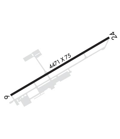
| Rwy | Rwy | |||||||
| 4471x75 | 4471' | 4471x75 | 4471' | 108.30 - 241° | ||||
| Runway ID | Single Wheel | Double Wheel | Double Tandem Wheel | Dual Double Wheel |
| 06/24 | 30,000 | N/A | N/A | N/A |
| These numbers are Advisory and are not limits. The Airport Manager should have more accurate Weight Limits | ||||
 Airport Diagram might not be current. | |
| Facility Name: | VIRGINIA HIGHLANDS |
| City Name: | ABINGDON |
| County: | WASHINGTON |
| State abbrev: | VA |
| State Name: | VIRGINIA |
| Ownership: | PUBLICLY OWNED |
| Use: | OPEN TO THE PUBLIC |
| Owner's Name: | VA HIGHLANDS ARPT AUTHORITY |
| Address: | PO BOX 631 |
| ABINGDON, VA 24212 | |
| Owner's Phone: | 276-628-2909 |
| Manager's Name: | MICKEY HINES |
| Address: | PO BOX 631 |
| ABINGDON, VA 24212 | |
| Phone: | 276-628-2909 |
| FAA Region: | EASTERN |
| FAA Field Office: | DCA |
| Date | Sunrise | Sunset |
|---|---|---|
| 04/24/24 Wednesday | 6:42 | 20:11 |
| 04/25/24 Thursday | 6:40 | 20:12 |
| 04/26/24 Friday | 6:39 | 20:13 |
| 04/27/24 Saturday | 6:38 | 20:14 |
| 04/28/24 Sunday | 6:37 | 20:15 |
| 04/29/24 Monday | 6:36 | 20:16 |
| 04/30/24 Tuesday | 6:35 | 20:16 |
| 05/01/24 Wednesday | 6:34 | 20:17 |
| 05/02/24 Thursday | 6:32 | 20:18 |
| 05/03/24 Friday | 6:31 | 20:19 |
| 05/04/24 Saturday | 6:30 | 20:20 |
| 05/05/24 Sunday | 6:29 | 20:21 |
| 05/06/24 Monday | 6:28 | 20:22 |
| 05/07/24 Tuesday | 6:27 | 20:22 |
| Airport Attendance Schedule | 7 Days A Week 1200-0000Z; UNATNDD NEW YEAR'S DAY, JULY 4TH, THANKSGIVING DAY, AND CHRISTMAS DAY. |
| Airport Status | OPERATIONAL (This Status can change at any time - please check NOTAMS) |
| Airport Lighting Schedule | ACTVT ODALS RWY 24; REIL RWY 24; PAPI RWY 24; MIRL RWY 06/24 - CTAF. |
| Airport Storage Available | Tie Downs, Hanger |
| Extra Services Available | Charter, Flight Instruction, Aircraft Rental |
| Wind Indicator | YES - (lighted) |
| Control Tower | NO |
| CTAF Frequency | 122.800 |
| Unicom Frequency | 122.800 |
| Rotating Beacon Color | WG |
| Segmented Circle | YES |
| Landing Fee | NO |
| Airport Inspected | STATE - performed by STATE AERONAUTICAL PERSONNEL |
| Inspection Date | 08/30/2023 |
| Type of Fuel Available | Grade 100LL, JET A (freeze point -40C); -A PRIST, ANTI-ICING FUEL ADDITIVE AVBL.; -10FOR FUEL AFT HRS, ARNG BFR 0000Z HRS AT 276-628-6030 OR 276-274-4040. THERE IS A FEE CTC FBO. |
| Airframe Repair Service | MAJOR |
| Power Plant Repair Service | MAJOR |
| Latitude | N3641.2 |
| Longitude | W08202.0 (ESTIMATED) |
| Arpt Elevation | 2087ft (SURVEYED) |
| Magnetic Variation | 05W |
| 2 miles W | of ABINGDON |
| Traffic Pattern Altitude | 990 |
| Sectional Chart | CINCINNATI |
| Operations (Reported) | Yearly | Avg. Daily |
|---|---|---|
| General Aviation Transient | 14097 | 39 |
| General Aviation Local | 13484 | 37 |
| Air Taxi | 2758 | 8 |
| Commerical | 0 | 0 |
| Commuter | 0 | 0 |
| Military | 306 | 1 |
| Aircraft based on Field | |
|---|---|
| General Aviation Singles | 38 |
| General Aviation Multi | 9 |
| Jet Aircraft | 6 |
| General Aviation Helicopters | 4 |
| Military Aircraft | 0 |
| Gliders | 0 |
| Ultralights | 0; ULTRALIGHTS ON & INVOF ARPT. |
| FSS on field | NO |
| FSS tie-in | LEESBURG |
| FSS Phone | 1-800-WX-BRIEF |
| Who issues Notams | VJI |
| Notam D service at airport | YES |
| ARTCC Name | ATLANTA |
| Airport Certification | |
| Aircraft Rescue & Firefighting Index | None |
| Airport of Entry | No |
| Custom Landing Rights | No |
| Joint Civil/Military | No |
| Military Landing rights | YES |
| NATIONAL PLAN OF INTEGRATED AIRPORT SYSTEMS (NPIAS) |
| GRANT AGREEMENTS UNDER FAAP/ADAP/AIP |
| ASSURANCES PURSUANT TO TITLE VI, CIVIL RIGHTS ACT OF 1964 |
| WILDLIFE INVOF ARPT. |
| WHEN TRI CITIES APCH CLSD, FOR CD CTC ATLANTA ARTCC AT 770-210-7692. |
Airport Communications & Frequencies:
| |||||||||||||||||
| Runway: 06 | Runway: 24 | ||
| Mag heading: | 61° | Mag heading: | 241° |
| Rwy Slope: | .55% Up | Rwy Slope: | -.55% Down |
| Approach: | Approach: | LOC/DME | |
| Pattern: | Left Traffic | Pattern: | Left Traffic |
| Markings: | NONPRECISION INSTRUMENT | Markings: | NONPRECISION INSTRUMENT |
| Marking Condition: | FAIR | Marking Condition: | FAIR |
| Arresting Dev: | Arresting Dev: | ||
| Lat & Long: | N3641.0 W08202.4 | Lat. & Long.: | N3641.4 W08201.6 |
| Elev: | 2062.6 ft. MSL | Elev: | 2087.4 ft. MSL |
| TCH: | TCH: | 32 ft. AGL | |
| Visual Glide Path: | Visual Glide Path: | 4.00 degrees | |
| Displaced Threshold: | No | Displaced Threshold: | No |
| Touchdown Zone: | YES | Touchdown Zone: | YES |
| Touchdown Elev.: | 2067.7 feet | Touchdown Elev.: | 2087.4 feet |
| Visual Glide Slope: | Visual Glide Slope: | 2-Light PAPI on LEFT side of Runway | |
| RVR Equipment: | RVR Equipment: | ||
| RVV Equipment: | NO | RVV Equipment: | NO |
| Approach Lights: | Approach Lights: | ODALS - omnidirectional approach lighting system | |
| REIL: | NO | REIL: | YES |
| Centerline Lights: | NO | Centerline Lights: | NO |
| Touchdown lights: | NO | Touchdown lights: | NO |
| Runway Category: | Runway with a Non-precision Approach having visibility minimums greater than 3/4 mile | Runway Category: | Runway with a Non-precision Approach having visibility minimums greater than 3/4 mile |
| Declared Distances: | Declared Distances: | ||
| Obstructions: | TREE | Obstructions: | TREE |
| Marked: | NOT Marked/Lighted | Marked: | NOT Marked/Lighted |
| Clearance slope: | 25:1 | Clearance slope: | 24:1 |
| Obstruction height: | 151 feet AGL | Obstruction height: | 81 feet AGL |
| Dist. from runway: | 4032 feet | Dist. from runway: | 2166 feet |
| Centerline offset: | 255 left of centerline | Centerline offset: | 429 feet right of centerline |
| Comments: | Comments: |
