Current Weather/Notams (Metars, TAFs, Notams, NWS Forecast, PIREPS, and nearby weather)
Customs Information Send updates to Support@FltPlan.com
Customs Not Available
Database effective 05/16/2024
Airport Diagram might not be current.
|
| Facility Name: | CULBERSON COUNTY |
| City Name: | VAN HORN |
| County: | CULBERSON |
| State abbrev: | TX |
| State Name: | TEXAS |
| | |
| Ownership: | PUBLICLY OWNED |
| Use: | OPEN TO THE PUBLIC |
| Owner's Name: | CULBERSON COUNTY |
| Address: | 501 W. BROADWAY, PO BOX 927 |
| | VAN HORN, TX 79855 |
| Owner's Phone: | 915-283-2058 |
| | |
| Manager's Name: | JUDGE CARLOS URIAS |
| Address: | 501 W. BROADWAY, BOX 927 |
| | VAN HORN, TX 79855 |
| Phone: | 432-283-2059 |
| | |
| FAA Region: | SOUTHWEST |
| FAA Field Office: | TEX |
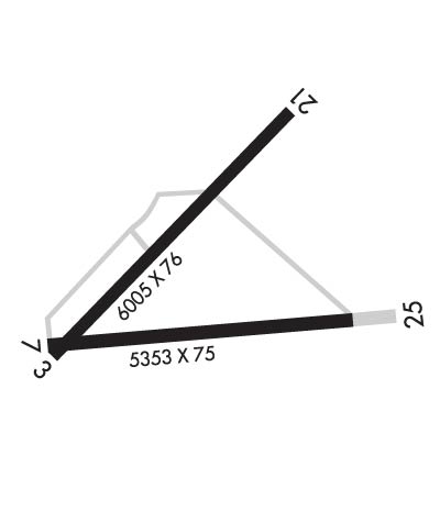
Runway Identifications
Runway Identification: 03/21Length: 6005 ft
Width: 76 ft
Surface: ASPHALT-GOOD CONDITION
Edge lights: Medium IntensityTreatment: NONE
| | Runway: 03 | | Runway: 21 |
| Mag heading: | 35° | Mag heading: | 215° |
| Rwy Slope: | -.63% Down | Rwy Slope: | .63% Up |
| Approach: | | Approach: | |
| Pattern: | Left Traffic | Pattern: | Left Traffic |
| Markings: | NONPRECISION INSTRUMENT | Markings: | NONPRECISION INSTRUMENT |
| Marking Condition: | GOOD | Marking Condition: | GOOD |
| Arresting Dev: | | Arresting Dev: | |
| Lat & Long: | N3103.3 W10447.5 | Lat. & Long.: | N3104.0 W10446.7 |
| Elev: | 3956.0 ft. MSL | Elev: | 3918.3 ft. MSL |
| TCH: | 45 ft. AGL | TCH: | 44 ft. AGL |
| Visual Glide Path: | 3.00 degrees | Visual Glide Path: | 3.00 degrees |
| Displaced Threshold: | No | Displaced Threshold: | No |
| Touchdown Zone: | YES | Touchdown Zone: | YES |
| Touchdown Elev.: | 3956.2 feet | Touchdown Elev.: | 3939.2 feet |
| Visual Glide Slope: | 2-Light PAPI on LEFT side of Runway | Visual Glide Slope: | 2-Light PAPI on LEFT side of Runway |
| RVR Equipment: | | RVR Equipment: | |
| RVV Equipment: | NO | RVV Equipment: | NO |
| Approach Lights: | | Approach Lights: | |
| REIL: | NO | REIL: | NO |
| Centerline Lights: | NO | Centerline Lights: | NO |
| Touchdown lights: | NO | Touchdown lights: | NO |
| Runway Category: | Runway with a Visual Approach | Runway Category: | Runway with a Non-precision Approach having visibility minimums greater than 3/4 mile |
| Declared Distances: | | Declared Distances: | |
| Obstructions: | BRUSH | Obstructions: | BRUSH |
| Marked: | NOT Marked/Lighted | Marked: | NOT Marked/Lighted |
| Clearance slope: | 7:1 | Clearance slope: | 4:1 |
| Obstruction height: | 10 feet AGL | Obstruction height: | 12 feet AGL |
| Dist. from runway: | 270 feet | Dist. from runway: | 258 feet |
| Centerline offset: | 250 left of centerline | Centerline offset: | 130 feet right of centerline |
| Comments: | 10 FT BRUSH, 30 FT DSTC, 250 FT L. | Comments: | 10 FT BRUSH, 0-200 FT DSTC. |
Runway Identification: 07/25Length: 5353 ft
Width: 75 ft
Surface: ASPHALT-GOOD CONDITION
Edge lights: Medium IntensityTreatment: NONE
| | Runway: 07 | | Runway: 25 |
| Mag heading: | 74° | Mag heading: | 254° |
| Rwy Slope: | -.86% Down | Rwy Slope: | .86% Up |
| Approach: | | Approach: | |
| Pattern: | Left Traffic | Pattern: | Left Traffic |
| Markings: | BASIC | Markings: | BASIC |
| Marking Condition: | FAIR | Marking Condition: | FAIR |
| Arresting Dev: | | Arresting Dev: | |
| Lat & Long: | N3103.3 W10447.5 | Lat. & Long.: | N3103.4 W10446.5 |
| Elev: | 3956.8 ft. MSL | Elev: | 3910.7 ft. MSL |
| TCH: | | TCH: | |
| Visual Glide Path: | | Visual Glide Path: | |
| Displaced Threshold: | No | Displaced Threshold: | No |
| Touchdown Zone: | YES | Touchdown Zone: | YES |
| Touchdown Elev.: | 3956.8 feet | Touchdown Elev.: | 3936.5 feet |
| Visual Glide Slope: | | Visual Glide Slope: | |
| RVR Equipment: | | RVR Equipment: | |
| RVV Equipment: | NO | RVV Equipment: | NO |
| Approach Lights: | | Approach Lights: | |
| REIL: | NO | REIL: | NO |
| Centerline Lights: | NO | Centerline Lights: | NO |
| Touchdown lights: | NO | Touchdown lights: | NO |
| Runway Category: | Runway with a Visual Approach | Runway Category: | Runway with a Visual Approach |
| Declared Distances: | | Declared Distances: | |
| Obstructions: | BRUSH | Obstructions: | |
| Marked: | NOT Marked/Lighted | Marked: | |
| Clearance slope: | 5:1 | Clearance slope: | 20:1 |
| Obstruction height: | 15 feet AGL | Obstruction height: | |
| Dist. from runway: | 276 feet | Dist. from runway: | |
| Centerline offset: | 125 right of centerline | Centerline offset: | |
| Comments: | | Comments: | |