Current Weather/Notams (Metars, TAFs, Notams, NWS Forecast, PIREPS, and nearby weather)
Customs Information Send updates to Support@FltPlan.com
Customs Not Available
Database effective 05/16/2024
Airport Diagram might not be current.
|
| Facility Name: | HAMILTON MUNI |
| City Name: | HAMILTON |
| County: | MADISON |
| State abbrev: | NY |
| State Name: | NEW YORK |
| | |
| Ownership: | PUBLICLY OWNED |
| Use: | OPEN TO THE PUBLIC |
| Owner's Name: | VILLAGE OF HAMILTON |
| Address: | PO BOX 119; 3 BROAD ST |
| | HAMILTON, NY 13346 |
| Owner's Phone: | 315-824-6681 |
| | |
| Manager's Name: | NANCY MITCHELL |
| Address: | 3 BROAD STREET - PO BOX 119 |
| | HAMILTON, NY 13346 |
| Phone: | 315-834-1111 |
| | |
| FAA Region: | EASTERN |
| FAA Field Office: | NYC |
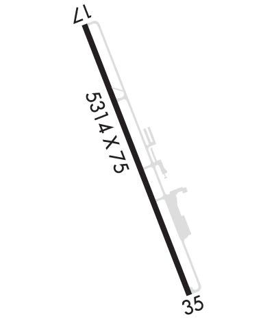
Runway Identifications
Runway Identification: 17/35Length: 5314 ft
Width: 75 ft
Surface: ASPHALT-GOOD CONDITION
Edge lights: Medium IntensityTreatment: GROOVED
| | Runway: 17 | | Runway: 35 |
| Mag heading: | 170° | Mag heading: | 350° |
| Rwy Slope: | -.18% Down | Rwy Slope: | .18% Up |
| Approach: | | Approach: | |
| Pattern: | Left Traffic | Pattern: | Left Traffic |
| Markings: | NONPRECISION INSTRUMENT | Markings: | NONPRECISION INSTRUMENT |
| Marking Condition: | GOOD | Marking Condition: | GOOD |
| Arresting Dev: | | Arresting Dev: | |
| Lat & Long: | N4251.0 W07533.9 | Lat. & Long.: | N4250.2 W07533.5 |
| Elev: | 1130.2 ft. MSL | Elev: | 1120.8 ft. MSL |
| TCH: | 40 ft. AGL | TCH: | 40 ft. AGL |
| Visual Glide Path: | 3.00 degrees | Visual Glide Path: | 4.00 degrees |
| Displaced Threshold: | 300 feet | Displaced Threshold: | No |
| Touchdown Zone: | YES | Touchdown Zone: | YES |
| Touchdown Elev.: | 1136.7 feet | Touchdown Elev.: | 1134.7 feet |
| Visual Glide Slope: | 2-Light PAPI on LEFT side of Runway | Visual Glide Slope: | 2-Light PAPI on LEFT side of Runway |
| RVR Equipment: | | RVR Equipment: | |
| RVV Equipment: | NO | RVV Equipment: | NO |
| Approach Lights: | | Approach Lights: | |
| REIL: | YES | REIL: | YES; RWY 35 REILS TEMPO OTS. |
| Centerline Lights: | NO | Centerline Lights: | NO |
| Touchdown lights: | NO | Touchdown lights: | NO |
| Runway Category: | Runway with a Non-precision Approach having visibility minimums greater than 3/4 mile | Runway Category: | Runway with a Non-precision Approach having visibility minimums greater than 3/4 mile |
| Declared Distances: | TORA:5314' TODA:5314' ASDA:5314' LDA:5014' | Declared Distances: | TORA:5314' TODA:5314' ASDA:5014' LDA:5014' |
| Obstructions: | TREES | Obstructions: | TREES |
| Marked: | NOT Marked/Lighted | Marked: | NOT Marked/Lighted |
| Clearance slope: | 23:1; RWY 17 CLNC SLOPE 29:1 TO DTHR. | Clearance slope: | 5:1 |
| Obstruction height: | 79 feet AGL | Obstruction height: | 54 feet AGL |
| Dist. from runway: | 2046 feet | Dist. from runway: | 503 feet |
| Centerline offset: | 510 left of centerline | Centerline offset: | 273 feet left of centerline |
| Comments: | 13 FT BRUSH, 90 FT FM RWY END, 75 - 222 FT RIGHT. | Comments: | 5 FT. BERM, 109 FT FM THRESHOLD, 179 FT RIGHT. |