Current Weather/Notams (Metars, TAFs, Notams, NWS Forecast, PIREPS, and nearby weather)
Customs Information Send updates to Support@FltPlan.com
Customs Not Available
Database effective 04/18/2024
Airport Diagram might not be current.
|
| Facility Name: | TAMPA EXEC |
| City Name: | TAMPA |
| County: | HILLSBOROUGH |
| State abbrev: | FL |
| State Name: | FLORIDA |
| | |
| Ownership: | PUBLICLY OWNED |
| Use: | OPEN TO THE PUBLIC |
| Owner's Name: | HILLSBOROUGH COUNTY AVIATION AUTH |
| Address: | PO BOX 22287 |
| | TAMPA, FL 33622 |
| Owner's Phone: | (813) 870-8776 |
| | |
| Manager's Name: | BRETT W FAY, C.M. |
| Address: | PO BOX 22287 |
| | TAMPA, FL 33622 |
| Phone: | (813) 870-8735 |
| | |
| FAA Region: | SOUTHERN |
| FAA Field Office: | ORL |
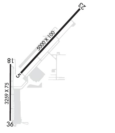
Runway Identifications
Runway Identification: 05/23Length: 5000 ft
Width: 100 ft
Surface: ASPHALT
Edge lights: Medium IntensityTreatment: NONE
Weight: PCN 12 /F/A/X/T
| | Runway: 05 | | Runway: 23 |
| Mag heading: | 46° | Mag heading: | 226° |
| Rwy Slope: | .04% Up | Rwy Slope: | -.04% Down |
| Approach: | | Approach: | ILS/DME |
| Pattern: | Left Traffic | Pattern: | Left Traffic |
| Markings: | NONPRECISION INSTRUMENT | Markings: | PRECISION INSTRUMENT |
| Marking Condition: | GOOD | Marking Condition: | GOOD |
| Arresting Dev: | | Arresting Dev: | |
| Lat & Long: | N2800.7 W08220.9 | Lat. & Long.: | N2801.3 W08220.2 |
| Elev: | 19.2 ft. MSL | Elev: | 21.0 ft. MSL |
| TCH: | 45 ft. AGL | TCH: | 40 ft. AGL |
| Visual Glide Path: | 3.02 degrees | Visual Glide Path: | 3.10 degrees |
| Displaced Threshold: | No | Displaced Threshold: | 800 feet |
| Touchdown Zone: | YES | Touchdown Zone: | YES |
| Touchdown Elev.: | 21.0 feet | Touchdown Elev.: | 21.1 feet |
| Visual Glide Slope: | 2-Light PAPI on LEFT side of Runway | Visual Glide Slope: | 2-Light PAPI on LEFT side of Runway |
| RVR Equipment: | | RVR Equipment: | |
| RVV Equipment: | NO | RVV Equipment: | NO |
| Approach Lights: | | Approach Lights: | MALSR - 1,400 foot medium intensity approach lighting system with runway alignment indicator lights |
| REIL: | YES | REIL: | NO |
| Centerline Lights: | NO | Centerline Lights: | NO |
| Touchdown lights: | NO | Touchdown lights: | NO |
| Runway Category: | Runway with a Non-precision Approach having visibility minimums greater than 3/4 mile | Runway Category: | Precision Instrument Runway |
| Declared Distances: | TORA:4574' TODA:4574' ASDA:4956' LDA:4956' | Declared Distances: | TORA:5000' TODA:5000' ASDA:5000' LDA:4200' |
| Obstructions: | TREES | Obstructions: | ROAD |
| Marked: | NOT Marked/Lighted | Marked: | NOT Marked/Lighted |
| Clearance slope: | 40:1 | Clearance slope: | 6:1; RWY 23 APCH SLOPE 50:1 TO DTHR. |
| Obstruction height: | 43 feet AGL | Obstruction height: | 17 feet AGL |
| Dist. from runway: | 1955 feet | Dist. from runway: | 310 feet |
| Centerline offset: | 245 left of centerline | Centerline offset: | 500 feet left of centerline |
| Comments: | | Comments: | |
Runway Identification: 18/36Length: 3219 ft
Width: 75 ft
Surface: ASPHALT-FAIR CONDITION
Edge lights: Medium IntensityTreatment: NONE
Weight: PCN 21 /F/B/X/T
| | Runway: 18 | | Runway: 36 |
| Mag heading: | 184° | Mag heading: | 4° |
| Rwy Slope: | .00% Up | Rwy Slope: | .00% Down |
| Approach: | | Approach: | |
| Pattern: | Left Traffic | Pattern: | Left Traffic |
| Markings: | NONPRECISION INSTRUMENT | Markings: | NONPRECISION INSTRUMENT |
| Marking Condition: | FAIR | Marking Condition: | FAIR |
| Arresting Dev: | | Arresting Dev: | |
| Lat & Long: | N2800.8 W08221.0 | Lat. & Long.: | N2800.3 W08221.0 |
| Elev: | 18.4 ft. MSL | Elev: | 18.5 ft. MSL |
| TCH: | 41 ft. AGL | TCH: | 43 ft. AGL |
| Visual Glide Path: | 3.80 degrees | Visual Glide Path: | 3.40 degrees |
| Displaced Threshold: | No | Displaced Threshold: | No |
| Touchdown Zone: | YES | Touchdown Zone: | YES |
| Touchdown Elev.: | 18.9 feet | Touchdown Elev.: | 18.9 feet |
| Visual Glide Slope: | 4-Light PAPI on RIGHT side of Runway | Visual Glide Slope: | 2-Light PAPI on LEFT side of Runway |
| RVR Equipment: | | RVR Equipment: | |
| RVV Equipment: | NO | RVV Equipment: | NO |
| Approach Lights: | | Approach Lights: | |
| REIL: | YES | REIL: | YES |
| Centerline Lights: | NO | Centerline Lights: | NO |
| Touchdown lights: | NO | Touchdown lights: | NO |
| Runway Category: | Runway with a Non-precision Approach | Runway Category: | Runway with a Visual Approach |
| Declared Distances: | TORA:3219' TODA:3219' ASDA:3219' LDA:3219' | Declared Distances: | TORA:3219' TODA:3219' ASDA:3219' LDA:3219' |
| Obstructions: | BRUSH | Obstructions: | POLE |
| Marked: | NOT Marked/Lighted | Marked: | LIGHTED |
| Clearance slope: | 17:1; RWY 18 APCH SLOPE 30:1 TO AER. | Clearance slope: | 22:1 |
| Obstruction height: | 16 feet AGL | Obstruction height: | 123 feet AGL |
| Dist. from runway: | 485 feet | Dist. from runway: | 2895 feet |
| Centerline offset: | 100 left of centerline | Centerline offset: | 20 feet left of centerline |
| Comments: | | Comments: | |

