Skytech Inc.

KUZA

ROCK HILL/YORK CO/BRYANT FIELD
ROCK HILL
SC
Time Zone: Eastern
Lat: N 3459.3
Long: W 08103.4
Elev: 666
Var: +05
Longest Runway: 5500
Clr Del: 126.85
AWOS: 120.77
CTAF: 123.05

FBO & Flight Services info for KUZA

FBOs: Update your Fuel Prices
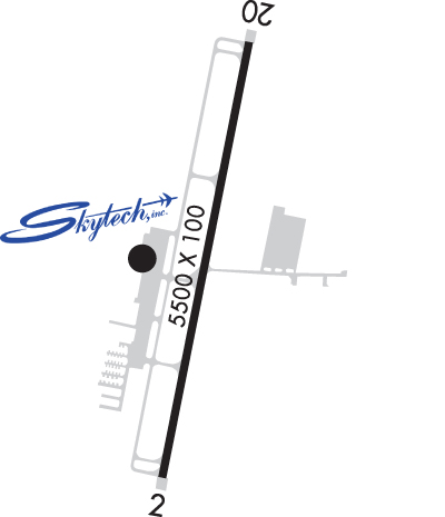
Just 15 miles south of CLT, we feature a full ILS approach, new terminal building, and a complete range of services for both piston aircraft and the largest corporate jets. Skytech is a full-service FBO featuring piston and turbine maintenance, full avionics repair and installations, Shell fuel and oil, and many other amenities associated with much larger operations.
Ph: 888-386-3596 Fax: 803-366-1519 Freq: 123.05WebsiteE-Mail
                          
Service
Jet
100LL
SAF
MoGas
Fuel Avail: 24 HRS (ADDITIONAL FEES FOR AFTER HOURS)
Full6.857.25    Last Update: 04/23/2024 11:10
PRICES GUARANTEED by FBO.
Self  6.64    
Misc. Info: Cash & Phillips Card Discount; Jet A Volume Discounts @251 & 500 GalsAddress: 550 AIRPORT RD, SUITE 211,   ROCK HILL, SC 29732

ASOSPh: 803-981-9388
-
Freq: 120.77  
If you are an FBO, call 1-203-262-1700 to update your info or email: FltPlan.Advertising@garmin.com
Advertise your FBO on FltPlan.com
FBOs at nearby airports who want your business:
KCLT


  click here  
Voted #1 Best Small FBO Chain by Pro-Pilot Magazine for the 15th time. Jet A $.50 cents discounts start at 300 gallons. Earn rewards cash back for fuel purchased under Titan Reward Program. Open 24 hours. Full-time hotel style concierges and valets on staff.
Ph: 704-359-0440 WebsiteE-MailFax: 704-359-0280 Freq: 129.4

Runway & Approach Info for KUZA
Rwy
Length
Land Dist**
Approach*
  Rwy
Length
Land Dist**
Approach*
02
5500x100  5500'          
ILS/DME
 108.50 - 016°  
  
20
  5500x100  5500'          
 
 * only ILS, LOC, LDA, and SDF approaches to a specific runway are shown
** For any Declared Landing Distance Available, please see A/FD or Approach plates
Runway Weight Capability (lbs.) Help
Runway IDSingle WheelDouble WheelDouble Tandem WheelDual Double Wheel
02/2078,000104,000N/AN/A
These numbers are Advisory and are not limits.   The Airport Manager should have more accurate Weight Limits
Approach Charts
Wilson Air Center - The Plane Best!Approaches    
Current Weather/Notams
Customs Information Send updates to Support@FltPlan.com
Customs Not Available
Database effective 05/16/2024
Airport Diagram of KUZA
Airport Diagram might not be current.

Facility Name: ROCK HILL/YORK COUNTY/BRYANT FLD
City Name: ROCK HILL
County: YORK
State abbrev: SC
State Name: SOUTH CAROLINA
   
Ownership: PUBLICLY OWNED
Use: OPEN TO THE PUBLIC
Owner's Name: CITY OF ROCK HILL
Address: BOX 11706
 ROCK HILL, SC 29731
Owner's Phone: 803-329-7010
  
Manager's Name: STEVEN A. GOULD JR., C.M.; FBO - SKYTECH, AARON COPE 803-366-5108.
Address: 550 AIRPORT RD, SUITE 205
 ROCK HILL, SC 29732
Phone: 803-329-5560
   
FAA Region: SOUTHERN
FAA Field Office: ATL


Sunrise / Sunset times for ROCK HILL/YORK COUNTY/BRYANT FLD

DateSunriseSunset
04/25/24 Thursday6:3920:05
04/26/24 Friday6:3820:06
04/27/24 Saturday6:3720:07
04/28/24 Sunday6:3620:08
04/29/24 Monday6:3520:09
04/30/24 Tuesday6:3420:10
05/01/24 Wednesday6:3320:10
05/02/24 Thursday6:3220:11
05/03/24 Friday6:3120:12
05/04/24 Saturday6:3020:13
05/05/24 Sunday6:2920:14
05/06/24 Monday6:2820:14
05/07/24 Tuesday6:2720:15
05/08/24 Wednesday6:2620:16

Airport Facilities

Airport Attendance ScheduleMON-FRI 0700-2000, SAT-SUN 0800-2000
Airport Status OPERATIONAL (This Status can change at any time - please check NOTAMS)
Airport Lighting ScheduleDUSK-2300. MIRL RWY 02/20 & MALSR RWY 02 PRESET MED INTST DUSK-2300; TO INCR INTST & ACTVT AFTER 2300 - CTAF.
Airport Storage AvailableTie Downs, Hanger
Extra Services AvailableAir Freight, Air Ambulance, Charter, Flight Instruction, Aircraft Rental, Aircraft Sales, Annual Surveying
Wind IndicatorYES - (lighted)
Control TowerNO
CTAF Frequency123.050
Unicom Frequency123.050
Rotating Beacon ColorWG
Segmented CircleYES
Landing FeeNO

Airport Inspection Data

Airport InspectedSTATE - performed by STATE AERONAUTICAL PERSONNEL
Inspection Date09/24/2021

Airport Services

Type of Fuel AvailableGrade 100LL, JET A (freeze point -40C)
Airframe Repair ServiceMAJOR
Power Plant Repair ServiceMAJOR

Geographic Data

LatitudeN3459.3
LongitudeW08103.4 (ESTIMATED)
Arpt Elevation666ft (SURVEYED)
Magnetic Variation05W
4 miles NWof ROCK HILL
Traffic Pattern Altitude
Sectional ChartCHARLOTTE

Aircraft Data

Operations (Reported)YearlyAvg. Daily
General Aviation Transient 1290335
General Aviation Local 1964054
Air Taxi 12894
Commerical 00
Commuter 00
Military 1000
Aircraft based on Field
General Aviation Singles 148
General Aviation Multi 15
Jet Aircraft 2
General Aviation Helicopters 5
Military Aircraft 0
Gliders 0
Ultralights 0

FAA Services

FSS on field NO
FSS tie-in ANDERSON
FSS Phone 1-800-WX-BRIEF
Who issues Notams UZA
Notam D service at airport YES
ARTCC Name ATLANTA

Federal Status

Airport Certification
Aircraft Rescue & Firefighting IndexNone
Airport of EntryNo
Custom Landing RightsNo
Joint Civil/MilitaryNo
Military Landing rightsYES

Federal Agreements

NATIONAL PLAN OF INTEGRATED AIRPORT SYSTEMS (NPIAS)
GRANT AGREEMENTS UNDER FAAP/ADAP/AIP
ASSURANCES PURSUANT TO TITLE VI, CIVIL RIGHTS ACT OF 1964

Remarks

WILDLIFE INVOF ARPT.
VOLUNTARY NOISE ABATEMENT PROC IN EFCT.
FOR CD IF UNA TO CTC ON FSS FREQ, CTC CHARLOTTE APCH AT 704-359-0241.
GCO AVBL ON FREQ 121.725 TO CHARLOTTE APCH.
Airport Communications & Frequencies:
CTAF Frequency:
123.050
Unicom Frequency:
123.050
CHARLOTTE Primary Approach Frequencies:  
120.05
307.8
CHARLOTTE Primary Departure Frequencies:  
120.05
307.8
Runway Identifications
Runway Identification: 02/20
Length: 5500 ft
Width: 100 ft
Surface: ASPHALT-GOOD CONDITION
Edge lights: Medium Intensity

Treatment: GROOVED
Weight: PCN 30 /F/C/X/T

 Runway: 02   Runway: 20
Mag heading: 16°Mag heading: 196°
Rwy Slope: -.10% DownRwy Slope: .10% Up
Approach: ILS/DMEApproach:
Pattern: Left TrafficPattern: Left Traffic
Markings: PRECISION INSTRUMENTMarkings: PRECISION INSTRUMENT
Marking Condition: GOODMarking Condition: GOOD
Arresting Dev: Arresting Dev:
Lat & Long: N3458.8  W08103.5Lat. & Long.: N3459.7  W08103.3
Elev: 666.3 ft. MSLElev: 661.0 ft. MSL
TCH: 41 ft. AGLTCH: 40 ft. AGL
Visual Glide Path: 3.00 degreesVisual Glide Path: 3.00 degrees
Displaced Threshold: NoDisplaced Threshold: No
Touchdown Zone: YESTouchdown Zone: YES
Touchdown Elev.: 666.3 feetTouchdown Elev.: 662.4 feet
Visual Glide Slope: 2-Light PAPI on LEFT side of RunwayVisual Glide Slope: 2-Light PAPI on LEFT side of Runway
RVR Equipment: RVR Equipment:
RVV Equipment: NORVV Equipment: NO
Approach Lights: MALSR - 1,400 foot medium intensity approach lighting system with runway alignment indicator lightsApproach Lights:
REIL: NOREIL: NO
Centerline Lights: NOCenterline Lights: NO
Touchdown lights: NOTouchdown lights: NO
Runway Category: Precision Instrument RunwayRunway Category: Runway with a Non-precision Approach having visibility minimums greater than 3/4 mile
Declared Distances: Declared Distances:
Obstructions: OTHER; CRANES.Obstructions: TREE
Marked: NOT Marked/LightedMarked: NOT Marked/Lighted
Clearance slope: 13:1Clearance slope: 19:1
Obstruction height: 124 feet AGLObstruction height: 85 feet AGL
Dist. from runway: 1826 feetDist. from runway: 1825 feet
Centerline offset: 912 left of centerlineCenterline offset: 523 feet left of centerline
Comments: Comments:
C:42/P: