Current Weather/Notams (Metars, TAFs, Notams, NWS Forecast, PIREPS, and nearby weather)
Customs Information Send updates to Support@FltPlan.com
Customs Not Available
Database effective 05/16/2024
Airport Diagram might not be current.
|
| Facility Name: | MADISON COUNTY |
| City Name: | LONDON |
| County: | MADISON |
| State abbrev: | OH |
| State Name: | OHIO |
| | |
| Ownership: | PUBLICLY OWNED |
| Use: | OPEN TO THE PUBLIC |
| Owner's Name: | MADISON COUNTY AIRPORT AUTH |
| Address: | 1281 US HIGHWAY 40 SW |
| | LONDON, OH 43140-9213 |
| Owner's Phone: | 740-852-5040 |
| | |
| Manager's Name: | JOHN DUHL |
| Address: | 1281 US HIGHWAY 40 SW |
| | LONDON, OH 43140-9213 |
| Phone: | 740-852-5040 |
| | |
| FAA Region: | GREAT LAKES |
| FAA Field Office: | DET |
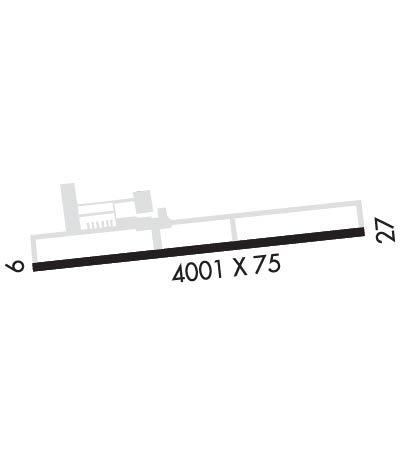
Runway Identifications
Runway Identification: 09/27Length: 4000 ft
Width: 75 ft
Surface: ASPHALT
Edge lights: Medium IntensityTreatment: GROOVED
| | Runway: 09 | | Runway: 27 |
| Mag heading: | 93° | Mag heading: | 273° |
| Rwy Slope: | -.76% Down | Rwy Slope: | .76% Up |
| Approach: | | Approach: | |
| Pattern: | Left Traffic | Pattern: | Left Traffic |
| Markings: | NONPRECISION INSTRUMENT | Markings: | NONPRECISION INSTRUMENT |
| Marking Condition: | GOOD | Marking Condition: | GOOD |
| Arresting Dev: | | Arresting Dev: | |
| Lat & Long: | N3955.9 W08328.1 | Lat. & Long.: | N3956.0 W08327.3 |
| Elev: | 1081.5 ft. MSL | Elev: | 1051.0 ft. MSL |
| TCH: | 29 ft. AGL | TCH: | 30 ft. AGL |
| Visual Glide Path: | 3.00 degrees | Visual Glide Path: | 3.00 degrees |
| Displaced Threshold: | No | Displaced Threshold: | No |
| Touchdown Zone: | YES | Touchdown Zone: | YES |
| Touchdown Elev.: | 1081.6 feet | Touchdown Elev.: | 1073.0 feet |
| Visual Glide Slope: | 4-Light PAPI on LEFT side of Runway | Visual Glide Slope: | 4-Light PAPI on LEFT side of Runway |
| RVR Equipment: | | RVR Equipment: | |
| RVV Equipment: | NO | RVV Equipment: | NO |
| Approach Lights: | | Approach Lights: | |
| REIL: | YES | REIL: | YES |
| Centerline Lights: | NO | Centerline Lights: | NO |
| Touchdown lights: | NO | Touchdown lights: | NO |
| Runway Category: | Runway with a Non-precision Approach | Runway Category: | Runway with a Non-precision Approach |
| Declared Distances: | | Declared Distances: | |
| Obstructions: | | Obstructions: | TREE |
| Marked: | | Marked: | NOT Marked/Lighted |
| Clearance slope: | 20:1 | Clearance slope: | 4:1 |
| Obstruction height: | | Obstruction height: | 7 feet AGL |
| Dist. from runway: | | Dist. from runway: | 228 feet |
| Centerline offset: | | Centerline offset: | 236 feet right of centerline |
| Comments: | | Comments: | +3-12 FT BRUSH/TREES, 60-200 FT DIST, 175 FT R. |

