Click here for more info on on SMS!

KUWL

NEW CASTLE-HENRY CO. MUNI.
NEW CASTLE
IN
Time Zone: Eastern
Lat: N 3952.6
Long: W 08519.5
Elev: 1090
Var: +06
Longest Runway: 4201
CTAF: 123.05

FBO & Flight Services info for KUWL

FBOs: Update your Fuel Prices
Providing high quality fuel and services to you and your customers, from Phillips 66 Aviation. Amenities Include: Refreshment & Snack Vending, Pilot Supplies, Lounge, and Rest Room.
Ph: 765-529-7903
-
Freq: 123.05Website-
Service
Jet
100LL
SAF
MoGas
Fuel Avail: PRIST PREMIXED. Cash discount with 100LL
Full4.955.90    Last Update: 04/01/2024 12:52

Self        
Misc. Info: Courtesy car now availableAddress: 2912 E 400 S,   NEWCASTLE, IN 47362

If you are an FBO, call 1-203-262-1700 to update your info or email: FltPlan.Advertising@garmin.com
Advertise your FBO on FltPlan.com

Runway & Approach Info for KUWL
Rwy
Length
Land Dist**
Approach*
  Rwy
Length
Land Dist**
Approach*
10
4201x75  4201'          
 
  
28
  4201x75  4201'          
 
 * only ILS, LOC, LDA, and SDF approaches to a specific runway are shown
** For any Declared Landing Distance Available, please see A/FD or Approach plates
Runway Weight Capability (lbs.) Help
Runway IDSingle WheelDouble WheelDouble Tandem WheelDual Double Wheel
10/28N/AN/AN/AN/A
These numbers are Advisory and are not limits.   The Airport Manager should have more accurate Weight Limits
Approach Charts
Approaches    
Current Weather/Notams
Customs Information Send updates to Support@FltPlan.com
Customs Not Available
Database effective 04/18/2024
Airport Diagram of KUWL
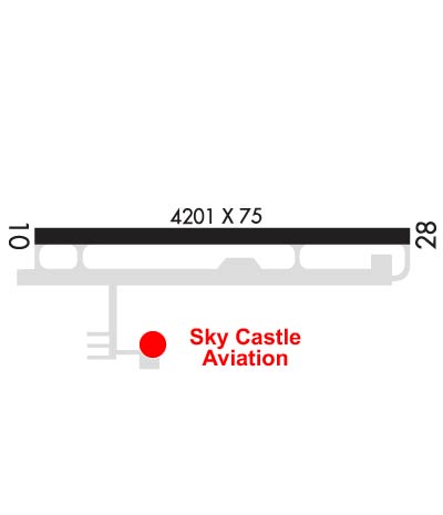
Airport Diagram might not be current.

Facility Name: NEW CASTLE HENRY COUNTY MARLATT FLD
City Name: NEW CASTLE
County: HENRY
State abbrev: IN
State Name: INDIANA
   
Ownership: PUBLICLY OWNED
Use: OPEN TO THE PUBLIC
Owner's Name: NEW CASTLE/HENRY COUNTY
Address: 2912 E. CO. RD. 400 S.
 NEW CASTLE, IN 47362
Owner's Phone: 765-529-7903
  
Manager's Name: JOHN MARLATT
Address: 2912 E CO. RD 400 S
 NEW CASTLE, IN 47362
Phone: 765-529-7903; 765-529-7909.
   
FAA Region: GREAT LAKES
FAA Field Office: CHI


Sunrise / Sunset times for NEW CASTLE HENRY COUNTY MARLATT FLD

DateSunriseSunset
04/18/24 Thursday6:5820:23
04/19/24 Friday6:5720:24
04/20/24 Saturday6:5520:25
04/21/24 Sunday6:5420:26
04/22/24 Monday6:5220:28
04/23/24 Tuesday6:5120:29
04/24/24 Wednesday6:5020:30
04/25/24 Thursday6:4820:31
04/26/24 Friday6:4720:32
04/27/24 Saturday6:4620:33
04/28/24 Sunday6:4420:34
04/29/24 Monday6:4320:35
04/30/24 Tuesday6:4220:36
05/01/24 Wednesday6:4120:37

Airport Facilities

Airport Attendance Schedule7 Days A Week 0800-1800; FUEL AFT HR - 765-332-2969.
Airport Status OPERATIONAL (This Status can change at any time - please check NOTAMS)
Airport Lighting ScheduleACTVT REIL RWY 10 & 28; PAPI RWY 10 & 28; MIRL RWY 10/28 - CTAF. MIRL RWY 10/28 PRESET LOW INTST; INCR INTST - CTAF.
Airport Storage AvailableTie Downs, Hanger
Extra Services AvailableAir Freight, Cargo Handling, Charter, Flight Instruction, Aircraft Rental
Wind IndicatorYES - (lighted)
Control TowerNO
CTAF Frequency123.050
Unicom Frequency123.050
Rotating Beacon ColorWG
Segmented CircleNO
Landing FeeNO

Airport Inspection Data

Airport InspectedSTATE - performed by STATE AERONAUTICAL PERSONNEL
Inspection Date07/11/2022

Airport Services

Type of Fuel AvailableGrade 100LL, JET A (freeze point -40C)
Airframe Repair ServiceMINOR
Power Plant Repair ServiceMINOR

Geographic Data

LatitudeN3952.6
LongitudeW08519.5 (ESTIMATED)
Arpt Elevation1090ft (SURVEYED)
Magnetic Variation06W
4 miles SEof NEW CASTLE
Traffic Pattern Altitude
Sectional ChartST LOUIS

Aircraft Data

Operations (Reported)YearlyAvg. Daily
General Aviation Transient 3621
General Aviation Local 18095
Air Taxi 900
Commerical 00
Commuter 00
Military 00
Aircraft based on Field
General Aviation Singles 15
General Aviation Multi 0
Jet Aircraft 0
General Aviation Helicopters 1
Military Aircraft 0
Gliders 0
Ultralights 0

FAA Services

FSS on field NO
FSS tie-in TERRE HAUTE
FSS Phone 1-800-WX-BRIEF
Who issues Notams HUF
Notam D service at airport YES
ARTCC Name INDIANAPOLIS

Federal Status

Airport Certification
Aircraft Rescue & Firefighting IndexNone
Airport of EntryNo
Custom Landing RightsNo
Joint Civil/MilitaryNo
Military Landing rightsNo

Federal Agreements

NATIONAL PLAN OF INTEGRATED AIRPORT SYSTEMS (NPIAS)

Remarks

FOR CD CTC INDIANAPOLIS APCH AT 317-227-5743.
Airport Communications & Frequencies:
CTAF Frequency:
123.050
Unicom Frequency:
123.050
INDIANAPOLIS Primary Approach Frequencies:  
135.45
317.8
INDIANAPOLIS Primary Departure Frequencies:  
135.45
317.8
Runway Identifications
Runway Identification: 10/28
Length: 4201 ft
Width: 75 ft
Surface: ASPHALT-GOOD CONDITION
Edge lights: Medium Intensity

Treatment: NONE

 Runway: 10   Runway: 28
Mag heading: 96°Mag heading: 276°
Rwy Slope: .24% UpRwy Slope: -.24% Down
Approach: Approach:
Pattern: Left TrafficPattern: Left Traffic
Markings: NONPRECISION INSTRUMENTMarkings: NONPRECISION INSTRUMENT
Marking Condition: GOODMarking Condition: GOOD
Arresting Dev: Arresting Dev:
Lat & Long: N3952.6  W08520.0Lat. & Long.: N3952.6  W08519.1
Elev: 1080.1 ft. MSLElev: 1090.1 ft. MSL
TCH: 46 ft. AGLTCH: 44 ft. AGL
Visual Glide Path: 3.00 degreesVisual Glide Path: 3.00 degrees
Displaced Threshold: NoDisplaced Threshold: No
Touchdown Zone: YESTouchdown Zone: YES
Touchdown Elev.: 1088.5 feetTouchdown Elev.: 1090.2 feet
Visual Glide Slope: 2-Light PAPI on LEFT side of RunwayVisual Glide Slope: 2-Light PAPI on LEFT side of Runway
RVR Equipment: RVR Equipment:
RVV Equipment: NORVV Equipment: NO
Approach Lights: Approach Lights:
REIL: YESREIL: YES
Centerline Lights: NOCenterline Lights: NO
Touchdown lights: NOTouchdown lights: NO
Runway Category: Runway Category:
Declared Distances: Declared Distances:
Obstructions: CROPSObstructions: CROPS
Marked: NOT Marked/LightedMarked: NOT Marked/Lighted
Clearance slope: 14:1Clearance slope: 1:1
Obstruction height: 10 feet AGLObstruction height: 10 feet AGL
Dist. from runway: 340 feetDist. from runway: 210 feet
Centerline offset: Centerline offset:
Comments: Comments:
C:1/P: