Current Weather/Notams (Metars, TAFs, Notams, NWS Forecast, PIREPS, and nearby weather)
Customs Information Send updates to Support@FltPlan.com
Phone 401-732-6701
Fax N/A
Comments Customs available 7 days a week. Business hours are 7:00 AM to 8:00 PM
Database effective 05/16/2024
Airport Diagram might not be current.
|
| Facility Name: | NEWPORT STATE |
| City Name: | NEWPORT |
| County: | NEWPORT |
| State abbrev: | RI |
| State Name: | RHODE ISLAND |
| | |
| Ownership: | PUBLICLY OWNED |
| Use: | OPEN TO THE PUBLIC |
| Owner's Name: | STATE OF RHODE ISLAND |
| Address: | RHODE ISLAND AIRPORT CORPORATION, 2000 POST RD |
| | WARWICK, RI 02886 |
| Owner's Phone: | 401-691-2000 |
| | |
| Manager's Name: | IFTIKHAR AHMAD |
| Address: | RHODE ISLAND AIRPORT CORP, 2000 POST RD |
| | WARWICK, RI 02886 |
| Phone: | 401-691-2000 |
| | |
| FAA Region: | NEW ENGLAND |
| FAA Field Office: | NONE |
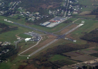
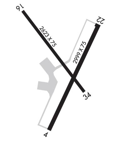
Runway Identifications
Runway Identification: 04/22Length: 2999 ft
Width: 75 ft
Surface: ASPHALT-POOR CONDITION
Edge lights: Medium IntensityTreatment: NONE
| | Runway: 04 | | Runway: 22 |
| Mag heading: | 39° | Mag heading: | 219° |
| Rwy Slope: | .78% Up | Rwy Slope: | -.78% Down |
| Approach: | | Approach: | LOC/DME |
| Pattern: | Left Traffic | Pattern: | Left Traffic |
| Markings: | BASIC | Markings: | NONPRECISION INSTRUMENT |
| Marking Condition: | FAIR | Marking Condition: | FAIR |
| Arresting Dev: | | Arresting Dev: | |
| Lat & Long: | N4131.7 W07117.0 | Lat. & Long.: | N4132.1 W07116.7 |
| Elev: | 148.3 ft. MSL | Elev: | 171.8 ft. MSL |
| TCH: | 51 ft. AGL | TCH: | 30 ft. AGL |
| Visual Glide Path: | 4.00 degrees | Visual Glide Path: | 4.00 degrees |
| Displaced Threshold: | TMPRY DTHR 499 FT. | Displaced Threshold: | No |
| Touchdown Zone: | YES | Touchdown Zone: | YES |
| Touchdown Elev.: | 171.8 feet | Touchdown Elev.: | 171.8 feet |
| Visual Glide Slope: | 4-BOX VASI ON LEFT SIDE OF RUNWAY; OTS UFN. | Visual Glide Slope: | 4-Light PAPI on LEFT side of Runway |
| RVR Equipment: | | RVR Equipment: | |
| RVV Equipment: | NO | RVV Equipment: | NO |
| Approach Lights: | | Approach Lights: | |
| REIL: | NO | REIL: | YES |
| Centerline Lights: | NO | Centerline Lights: | NO |
| Touchdown lights: | NO | Touchdown lights: | NO |
| Runway Category: | Runway with a Visual Approach | Runway Category: | Runway with a Non-precision Approach |
| Declared Distances: | | Declared Distances: | |
| Obstructions: | TREES | Obstructions: | TREES |
| Marked: | NOT Marked/Lighted | Marked: | NOT Marked/Lighted |
| Clearance slope: | 14:1; 22:1 FM TMPRY DTHR. | Clearance slope: | 14:1 |
| Obstruction height: | 75 feet AGL | Obstruction height: | 38 feet AGL |
| Dist. from runway: | 1250 feet | Dist. from runway: | 750 feet |
| Centerline offset: | 20 right of centerline | Centerline offset: | 250 feet left of centerline |
| Comments: | 10 FT TREES, 160 FT FM THR, 120 FT R; 20 FT TREES, 100 FT FM THR, 200 FT L. | Comments: | |
Runway Identification: 16/34Length: 2623 ft
Width: 75 ft
Surface: ASPHALT-FAIR CONDITION
Edge lights: Medium IntensityTreatment: NONE
| | Runway: 16 | | Runway: 34 |
| Mag heading: | 159° | Mag heading: | 339° |
| Rwy Slope: | .61% Up | Rwy Slope: | -.61% Down |
| Approach: | | Approach: | |
| Pattern: | Left Traffic | Pattern: | Left Traffic |
| Markings: | BASIC | Markings: | BASIC |
| Marking Condition: | FAIR | Marking Condition: | FAIR |
| Arresting Dev: | | Arresting Dev: | |
| Lat & Long: | N4132.2 W07117.1 | Lat. & Long.: | N4131.8 W07116.8 |
| Elev: | 146.3 ft. MSL | Elev: | 162.2 ft. MSL |
| TCH: | 40 ft. AGL | TCH: | |
| Visual Glide Path: | 3.75 degrees | Visual Glide Path: | |
| Displaced Threshold: | No | Displaced Threshold: | 250 feet |
| Touchdown Zone: | YES | Touchdown Zone: | YES |
| Touchdown Elev.: | 162.2 feet | Touchdown Elev.: | 162.2 feet |
| Visual Glide Slope: | 4-BOX VASI ON LEFT SIDE OF RUNWAY | Visual Glide Slope: | |
| RVR Equipment: | | RVR Equipment: | |
| RVV Equipment: | NO | RVV Equipment: | NO |
| Approach Lights: | | Approach Lights: | |
| REIL: | NO | REIL: | NO |
| Centerline Lights: | NO | Centerline Lights: | NO |
| Touchdown lights: | NO | Touchdown lights: | NO |
| Runway Category: | Runway with a Non-precision Approach | Runway Category: | Runway with a Visual Approach |
| Declared Distances: | | Declared Distances: | |
| Obstructions: | TREES | Obstructions: | TREES |
| Marked: | NOT Marked/Lighted | Marked: | NOT Marked/Lighted |
| Clearance slope: | 8:1 | Clearance slope: | 18:1; 29:1 FM DTHR. |
| Obstruction height: | 37 feet AGL | Obstruction height: | 37 feet AGL |
| Dist. from runway: | 525 feet | Dist. from runway: | 900 feet |
| Centerline offset: | 250 left of centerline | Centerline offset: | 200 feet right of centerline |
| Comments: | 10 FT FENCE/TREES 50 FT FM THR, 220 FT L; 10 FT TREES, 190 FT FM THR, 240 FT R. | Comments: | |