Click here for more info on on SMS!

KUSW

BOGGS FIELD
SPENCER
WV
Time Zone: Eastern
Lat: N 3849.4
Long: W 08120.9
Elev: 928
Var: +08
Longest Runway: 4549
AWOS: 118.57
CTAF: 122.72

FBO & Flight Services info for KUSW

FBOs: Update your Fuel Prices

BOGGS AVIATIONPh: 304-927-4045
-
Freq: 122.72
Service
Jet
100LL
SAF
MoGas
Fuel Avail: ~~TEMPORARILY NO FUEL AVAILABLE.
Full        Last Update: 04/25/2024 05:27:34

Self        
 Address: 217 AIRFIELD RD   SPENCER, WV 25276
AWOSPh: 304-927-0123
-
Freq: 118.57  
If you are an FBO, call 1-203-262-1700 to update your info or email: FltPlan.Advertising@garmin.com
Advertise your FBO on FltPlan.com

Runway & Approach Info for KUSW
Rwy
Length
Land Dist**
Approach*
  Rwy
Length
Land Dist**
Approach*
10
4549x75  4549'          
 
  
28
  4549x75  4549'          
 
 * only ILS, LOC, LDA, and SDF approaches to a specific runway are shown
** For any Declared Landing Distance Available, please see A/FD or Approach plates
Runway Weight Capability (lbs.) Help
Runway IDSingle WheelDouble WheelDouble Tandem WheelDual Double Wheel
10/28N/AN/AN/AN/A
These numbers are Advisory and are not limits.   The Airport Manager should have more accurate Weight Limits
Approach Charts
Approaches    
Current Weather/Notams
Customs Information Send updates to Support@FltPlan.com
Customs Not Available
Database effective 05/16/2024
Airport Diagram of KUSW
Airport Diagram might not be current.

Facility Name: BOGGS FLD
City Name: SPENCER
County: ROANE
State abbrev: WV
State Name: WEST VIRGINIA
   
Ownership: PRIVATELY OWNED
Use: OPEN TO THE PUBLIC
Owner's Name: BOGGS AVIATION, LLC
Address: 217 AIRFIELD ROAD
 SPENCER, WV 25276
Owner's Phone: 304-927-4045
  
Manager's Name: RICHARD C. BOGGS
Address: P.O. BOX 1001; ARPT PHYSICAL ADDRESS 217 AIRFIELD RD., SPENCER, WV 25726.
 SPENCER, WV 25276
Phone: 304-481-1214
   
FAA Region: EASTERN
FAA Field Office: BKW


Sunrise / Sunset times for BOGGS FLD

DateSunriseSunset
04/24/24 Wednesday6:3620:12
04/25/24 Thursday6:3420:13
04/26/24 Friday6:3320:14
04/27/24 Saturday6:3220:15
04/28/24 Sunday6:3020:16
04/29/24 Monday6:2920:17
04/30/24 Tuesday6:2820:18
05/01/24 Wednesday6:2720:19
05/02/24 Thursday6:2620:20
05/03/24 Friday6:2420:20
05/04/24 Saturday6:2320:21
05/05/24 Sunday6:2220:22
05/06/24 Monday6:2120:23
05/07/24 Tuesday6:2020:24

Airport Facilities

Airport Attendance ScheduleMON-FRI 0800-1600
Airport Status OPERATIONAL (This Status can change at any time - please check NOTAMS)
Airport Lighting ScheduleACTVT MIRL RWY 10/28 - CTAF.; ACTVT ROTG BCN - CTAF.
Airport Storage AvailableTie Downs, Hanger
Extra Services AvailableFlight Instruction, Aircraft Rental, Annual Surveying
Wind IndicatorYES - (lighted)
Control TowerNO
CTAF Frequency122.725
Unicom Frequency122.725
Rotating Beacon ColorWG
Segmented CircleNO
Landing Fee

Airport Inspection Data

Airport InspectedSTATE - performed by PRIVATE CONTRACT PERSONNEL
Inspection Date07/07/2022

Airport Services

Type of Fuel AvailableGrade 100LL, JET A (freeze point -40C); -1024 HR SELF SERVICE CREDIT CARD FUEL .
Airframe Repair ServiceMINOR
Power Plant Repair ServiceMINOR

Geographic Data

LatitudeN3849.4
LongitudeW08120.9 (ESTIMATED)
Arpt Elevation928ft (SURVEYED)
Magnetic Variation08W
1 miles Nof SPENCER
Traffic Pattern AltitudeTPA SINGLE/MULTI ENG ACFT 1000 FT, TURBINE/LARGE ACFT 1500 FT.
Sectional ChartCINCINNATI

Aircraft Data

Operations (Reported)YearlyAvg. Daily
General Aviation Transient 10003
General Aviation Local 20005
Air Taxi 00
Commerical 00
Commuter 00
Military 1000
Aircraft based on Field
General Aviation Singles 10
General Aviation Multi 2
Jet Aircraft 1
General Aviation Helicopters 2
Military Aircraft 0
Gliders 0
Ultralights 0

FAA Services

FSS on field NO
FSS tie-in ELKINS
FSS Phone 1-800-WX-BRIEF
Who issues Notams EKN
Notam D service at airport YES
ARTCC Name INDIANAPOLIS

Federal Status

Airport Certification
Aircraft Rescue & Firefighting IndexNone
Airport of EntryNo
Custom Landing RightsNo
Joint Civil/MilitaryNo
Military Landing rightsNo

Remarks

WILDLIFE & DEER ON & INVOF RWY.
NSTD RWY SAFETY AREA, 50 FT HILL, 170 FT FROM EACH SIDE OF RWY CL.
OCNL RC MODEL ACFT OPS ON RWY MIDFIELD.
FOR CD CTC CHARLESTON APCH AT 304-344-5867 EXT 281.
Airport Communications & Frequencies:
CTAF Frequency:
122.725
Unicom Frequency:
122.725
CHARLESTON Primary Approach Frequencies:  
124.1
269.125
CHARLESTON Primary Departure Frequencies:  
124.1
269.125
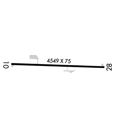
Runway Identifications
Runway Identification: 10/28
Length: 4549 ft
Width: 75 ft
Surface: ASPHALT-GOOD CONDITION
Edge lights: Medium Intensity

Treatment: NONE

 Runway: 10   Runway: 28
Mag heading: 100°Mag heading: 280°
Rwy Slope: .00% DownRwy Slope: .00% Up
Approach: Approach:
Pattern: Left TrafficPattern: Left Traffic
Markings: PRECISION INSTRUMENTMarkings: PRECISION INSTRUMENT
Marking Condition: POOR; PVMNT MKG FADED.Marking Condition: POOR; PVMNT MKG FADED.
Arresting Dev: Arresting Dev:
Lat & Long: N3849.4  W08121.4Lat. & Long.: N3849.4  W08120.5
Elev: 927.6 ft. MSLElev: 927.5 ft. MSL
TCH: TCH:
Visual Glide Path: Visual Glide Path:
Displaced Threshold: NoDisplaced Threshold: No
Touchdown Zone: YESTouchdown Zone: YES
Touchdown Elev.: 928.3 feetTouchdown Elev.: 928.3 feet
Visual Glide Slope: Visual Glide Slope:
RVR Equipment: RVR Equipment:
RVV Equipment: NORVV Equipment: NO
Approach Lights: Approach Lights:
REIL: NOREIL: NO
Centerline Lights: NOCenterline Lights: NO
Touchdown lights: NOTouchdown lights: NO
Runway Category: Runway with a Non-precision ApproachRunway Category: Runway with a Non-precision Approach
Declared Distances: Declared Distances:
Obstructions: TREESObstructions: GND
Marked: NOT Marked/LightedMarked: NOT Marked/Lighted
Clearance slope: 17:1Clearance slope: 25:1
Obstruction height: 72 feet AGLObstruction height: 160 feet AGL
Dist. from runway: 1425 feetDist. from runway: 4200 feet
Centerline offset: 400 left of centerlineCenterline offset:
Comments: 10 FT BRUSH, 30 FT DSTC.Comments: 10 FT BRUSH, 30 FT DSTC.
C:/P: