Click here for more info on on SMS!

KUSE

FULTON COUNTY
WAUSEON
OH
Time Zone: Eastern
Lat: N 4136.6
Long: W 08407.6
Elev: 781
Var: +05
Longest Runway: 3882
AWOS: 127.37
CTAF: 123.0

FBO & Flight Services info for KUSE

FBOs: Update your Fuel Prices

FULTON COUNTYPh: 419-335-3993 Fax: 419-335-6543 Freq: 123.0
Service
Jet
100LL
SAF
MoGas
Fuel Avail: JET A INCLUDES PRIST. 24/7
Full4.995.49    Last Update: 04/15/2024 12:34

Self4.995.49  6.19
 Address: 9464 CO RD 14   WAUSEON OH 43567
AWOSPh: 419-335-0775
-
Freq: 127.37  
If you are an FBO, call 1-203-262-1700 to update your info or email: FltPlan.Advertising@garmin.com
Advertise your FBO on FltPlan.com

Runway & Approach Info for KUSE
Rwy
Length
Land Dist**
Approach*
  Rwy
Length
Land Dist**
Approach*
09
3882x75  3882'          
 
  
27
  3882x75  3882'          
 
18
2115x75  2115'          
 
  
36
  2115x75  2115'          
 
 * only ILS, LOC, LDA, and SDF approaches to a specific runway are shown
** For any Declared Landing Distance Available, please see A/FD or Approach plates
Runway Weight Capability (lbs.) Help
Runway IDSingle WheelDouble WheelDouble Tandem WheelDual Double Wheel
09/2730,000N/AN/AN/A
18/36N/AN/AN/AN/A
These numbers are Advisory and are not limits.   The Airport Manager should have more accurate Weight Limits
Approach Charts
Approaches    
Current Weather/Notams
Customs Information Send updates to Support@FltPlan.com
Customs Not Available
Database effective 04/18/2024
Airport Diagram of KUSE
Airport Diagram might not be current.

Facility Name: FULTON COUNTY
City Name: WAUSEON
County: FULTON
State abbrev: OH
State Name: OHIO
   
Ownership: PUBLICLY OWNED
Use: OPEN TO THE PUBLIC
Owner's Name: FULTON COUNTY
Address: 9460 COUNTY ROAD 14
 WAUSEON, OH 43567-9670
Owner's Phone: 419-337-9255
  
Manager's Name: JOHN CRISP; KUSE@FULTONCOUNTYOH.COM.
Address: 9460 COUNTY ROAD 14
 WAUSEON, OH 43567-9670
Phone: 419-335-3993
   
FAA Region: GREAT LAKES
FAA Field Office: DET


Sunrise / Sunset times for FULTON COUNTY

DateSunriseSunset
04/19/24 Friday6:4920:22
04/20/24 Saturday6:4820:23
04/21/24 Sunday6:4620:25
04/22/24 Monday6:4520:26
04/23/24 Tuesday6:4320:27
04/24/24 Wednesday6:4220:28
04/25/24 Thursday6:4020:29
04/26/24 Friday6:3920:30
04/27/24 Saturday6:3820:31
04/28/24 Sunday6:3620:32
04/29/24 Monday6:3520:33
04/30/24 Tuesday6:3420:34
05/01/24 Wednesday6:3220:35
05/02/24 Thursday6:3120:36

Airport Facilities

Airport Attendance ScheduleMON-SAT 0800-1700; FOR SVC AFT HRS CALL AMGR.
Airport Status OPERATIONAL (This Status can change at any time - please check NOTAMS)
Airport Lighting ScheduleACTVT REIL RWY 09 & 27; PAPI RWY 09 & 27; MIRL RWY 09/27 - CTAF.
Airport Storage AvailableTie Downs, Hanger
Extra Services AvailableAir Ambulance
Wind IndicatorYES - (lighted)
Control TowerNO
CTAF Frequency123.000
Unicom Frequency123.000
Rotating Beacon ColorWG
Segmented CircleNO
Landing FeeNO

Airport Inspection Data

Airport InspectedSTATE - performed by STATE AERONAUTICAL PERSONNEL
Inspection Date06/30/2022

Airport Services

Type of Fuel AvailableGrade 100LL, JET A (freeze point -40C), JET A-1 (icing inhibitor, freeze point -50C)UL94; -10100LL AVBL H24 SELF SVC VIA CREDIT CARD.; -A FOR JET A AFT HRS CALL AMGR.; -ULUL94 AVBL H24 SELF SVC VIA CREDIT CARD.
Airframe Repair ServiceNONE
Power Plant Repair ServiceNONE

Geographic Data

LatitudeN4136.6
LongitudeW08407.6 (ESTIMATED)
Arpt Elevation780ft (SURVEYED)
Magnetic Variation05W
4 miles Nof WAUSEON
Traffic Pattern Altitude
Sectional ChartDETROIT

Aircraft Data

Operations (Reported)YearlyAvg. Daily
General Aviation Transient 1000027
General Aviation Local 1200033
Air Taxi 5001
Commerical 00
Commuter 00
Military 100
Aircraft based on Field
General Aviation Singles 21
General Aviation Multi 0
Jet Aircraft 0
General Aviation Helicopters 0
Military Aircraft 0
Gliders 1
Ultralights 0

FAA Services

FSS on field NO
FSS tie-in CLEVELAND
FSS Phone 1-800-WX-BRIEF
Who issues Notams USE
Notam D service at airport YES
ARTCC Name CLEVELAND

Federal Status

Airport Certification
Aircraft Rescue & Firefighting IndexNone
Airport of EntryNo
Custom Landing RightsNo
Joint Civil/MilitaryNo
Military Landing rightsNo

Federal Agreements

NATIONAL PLAN OF INTEGRATED AIRPORT SYSTEMS (NPIAS)

Remarks

DEER ON & INVOF ARPT.
RESTROOM ACCESS, UNICOM.
FOR CD CTC TOLEDO APCH AT 419-865-1495.
RWY 27 CLIMB STRAIGHT OUT TO 1300 MSL.
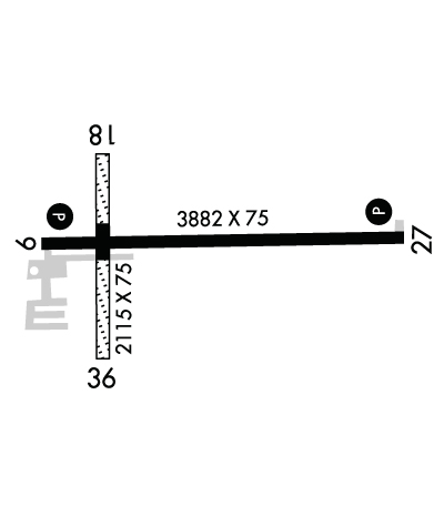
RWY 18/3 6 359 FT OF CNTR SECTION ASPH, NORTH 270 FT TURF, SOUTH 1328 FT TURF.
Airport Communications & Frequencies:
CTAF Frequency:
123.000
Unicom Frequency:
123.000
TOLEDO Primary Approach Frequencies:  
134.35
317.55
TOLEDO Primary Departure Frequencies:  
134.35
317.55
Runway Identifications
Runway Identification: 09/27
Length: 3882 ft
Width: 75 ft
Surface: ASPHALT-GOOD CONDITION
Edge lights: Medium Intensity

Treatment: NONE

 Runway: 09   Runway: 27
Mag heading: 94°Mag heading: 274°
Rwy Slope: -.23% DownRwy Slope: .23% Up
Approach: Approach:
Pattern: Left TrafficPattern: Left Traffic
Markings: NONPRECISION INSTRUMENTMarkings: NONPRECISION INSTRUMENT
Marking Condition: POOR; FADED.Marking Condition: POOR; FADED.
Arresting Dev: Arresting Dev:
Lat & Long: N4136.6  W08408.0Lat. & Long.: N4136.6  W08407.1
Elev: 778.8 ft. MSLElev: 770.0 ft. MSL
TCH: 24 ft. AGLTCH: 33 ft. AGL
Visual Glide Path: 3.00 degreesVisual Glide Path: 3.00 degrees
Displaced Threshold: NoDisplaced Threshold: No
Touchdown Zone: YESTouchdown Zone: YES
Touchdown Elev.: 779.1 feetTouchdown Elev.: 777.1 feet
Visual Glide Slope: 4-Light PAPI on LEFT side of RunwayVisual Glide Slope: 4-Light PAPI on RIGHT side of Runway
RVR Equipment: RVR Equipment:
RVV Equipment: NORVV Equipment: NO
Approach Lights: Approach Lights:
REIL: YESREIL: YES
Centerline Lights: NOCenterline Lights: NO
Touchdown lights: NOTouchdown lights: NO
Runway Category: Runway with a Non-precision ApproachRunway Category: Runway with a Non-precision Approach
Declared Distances: Declared Distances:
Obstructions: ROADObstructions: TREES
Marked: NOT Marked/LightedMarked: NOT Marked/Lighted
Clearance slope: 17:1Clearance slope: 17:1
Obstruction height: 15 feet AGLObstruction height: 70 feet AGL
Dist. from runway: 457 feetDist. from runway: 1417 feet
Centerline offset: Centerline offset: 429 feet left of centerline
Comments: +10 FT ACFT RAMP/PRKG, 0-142 FT DIST, 202-250 FT R.Comments:
Runway Identification: 18/36
Length: 2115 ft
Width: 75 ft
Surface: ASPHALT GRASS-GOOD CONDITION
Edge lights:

Treatment: NONE

 Runway: 18   Runway: 36
Mag heading: 185°Mag heading:
Rwy Slope: .17% UpRwy Slope: -.17% Down
Approach: Approach:
Pattern: Left TrafficPattern: Left Traffic
Markings: Markings:
Marking Condition: Marking Condition:
Arresting Dev: Arresting Dev:
Lat & Long: N4136.7  W08407.8Lat. & Long.: N4136.4  W08407.8
Elev: 777.0 ft. MSLElev: 780.6 ft. MSL
TCH: TCH:
Visual Glide Path: Visual Glide Path:
Displaced Threshold: NoDisplaced Threshold: No
Touchdown Zone: YESTouchdown Zone: YES
Touchdown Elev.: 780.8 feetTouchdown Elev.: 780.8 feet
Visual Glide Slope: Visual Glide Slope:
RVR Equipment: RVR Equipment:
RVV Equipment: NORVV Equipment: NO
Approach Lights: Approach Lights:
REIL: NOREIL: NO
Centerline Lights: NOCenterline Lights: NO
Touchdown lights: NOTouchdown lights: NO
Runway Category: Runway with a Visual ApproachRunway Category: Runway with a Visual Approach
Declared Distances: Declared Distances:
Obstructions: Obstructions: TREE
Marked: Marked: NOT Marked/Lighted
Clearance slope: 20:1Clearance slope: 17:1
Obstruction height: Obstruction height: 67 feet AGL
Dist. from runway: Dist. from runway: 1149 feet
Centerline offset: Centerline offset: 219 feet right of centerline
Comments: Comments:
C:/P: