| ||||||||||||||||||||||||||||||||||||||||||||
| ||||||||||||||||||||||||||||||||||||||||||||
| ||||||||||||||||||||||||||||||||||||||||||||
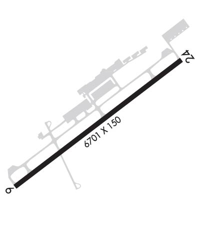
| Rwy | Rwy | |||||||
| 6701x150 | 6701' | 6701x150 | 6701' | 111.70 - 243° | ||||
| Runway ID | Single Wheel | Double Wheel | Double Tandem Wheel | Dual Double Wheel |
| 06/24 | 50,000 | 110,000 | N/A | N/A |
| These numbers are Advisory and are not limits. The Airport Manager should have more accurate Weight Limits | ||||
 Airport Diagram might not be current. | |
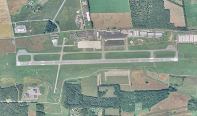
| Facility Name: | STATE COLLEGE RGNL |
| City Name: | STATE COLLEGE |
| County: | CENTRE |
| State abbrev: | PA |
| State Name: | PENNSYLVANIA |
| Ownership: | PUBLICLY OWNED |
| Use: | OPEN TO THE PUBLIC |
| Owner's Name: | PENN STATE UNIVERSITY |
| Address: | 2535 FOX HILL RD |
| STATE COLLEGE, PA 16803 | |
| Owner's Phone: | 814-865-4042 |
| Manager's Name: | BRYAN RODGERS |
| Address: | 2535 FOX HILL RD |
| STATE COLLEGE, PA 16803 | |
| Phone: | 814-865-4042 |
| FAA Region: | EASTERN |
| FAA Field Office: | HAR |
| Date | Sunrise | Sunset |
|---|---|---|
| 04/18/24 Thursday | 6:27 | 19:55 |
| 04/19/24 Friday | 6:25 | 19:56 |
| 04/20/24 Saturday | 6:24 | 19:57 |
| 04/21/24 Sunday | 6:22 | 19:58 |
| 04/22/24 Monday | 6:21 | 19:59 |
| 04/23/24 Tuesday | 6:20 | 20:00 |
| 04/24/24 Wednesday | 6:18 | 20:01 |
| 04/25/24 Thursday | 6:17 | 20:02 |
| 04/26/24 Friday | 6:15 | 20:03 |
| 04/27/24 Saturday | 6:14 | 20:04 |
| 04/28/24 Sunday | 6:13 | 20:05 |
| 04/29/24 Monday | 6:11 | 20:07 |
| 04/30/24 Tuesday | 6:10 | 20:08 |
| 05/01/24 Wednesday | 6:09 | 20:09 |
| Airport Attendance Schedule | CONTINUOUS |
| Airport Status | OPERATIONAL (This Status can change at any time - please check NOTAMS) |
| Airport Lighting Schedule | WHEN ATCT CLSD ACTVT MALSR RWY 24; REIL RWY 06; HIRL RWY 06/24 & TWY LGTS - CTAF. |
| Airport Storage Available | Tie Downs, Hanger |
| Extra Services Available | Air Ambulance, Cargo Handling, Charter, Flight Instruction, Aircraft Rental |
| Wind Indicator | YES - (lighted) |
| Control Tower | YES |
| CTAF Frequency | 128.475 |
| Unicom Frequency | 122.950 |
| Rotating Beacon Color | WG |
| Segmented Circle | YES |
| Landing Fee | YES; LNDG FEE FOR SNGL ENG, MULTI ENG ACFT & HELICOPTERS. SPL EVENT FEE FOR SNGL ENG, MULTI ENG ACFT & HELICOPTERS ON UNIVERSITY HOME FOOTBALL GAME WKENDS. |
| Airport Inspected | FEDERAL - performed by FAA AIRPORTS FIELD PERSONNEL |
| Inspection Date | 03/28/2023 |
| Type of Fuel Available | Grade 100LL, JET A (freeze point -40C) |
| Airframe Repair Service | MAJOR |
| Power Plant Repair Service | MINOR |
| Latitude | N4051.0 |
| Longitude | W07750.9 (ESTIMATED) |
| Arpt Elevation | 1231ft (ESTIMATED) |
| Magnetic Variation | 11W |
| 3 miles N | of STATE COLLEGE |
| Traffic Pattern Altitude | TRAFFIC PATTERN ALTITUDE FOR SINGLE ENGINE ACRFT 961 FT; MULTI ENGINE ACRFT 1461 FT. |
| Sectional Chart | DETROIT |
| Operations (Reported) | Yearly | Avg. Daily |
|---|---|---|
| General Aviation Transient | 14806 | 41 |
| General Aviation Local | 16924 | 46 |
| Air Taxi | 7932 | 22 |
| Commerical | 1376 | 4 |
| Commuter | 0 | 0 |
| Military | 721 | 2 |
| Aircraft based on Field | |
|---|---|
| General Aviation Singles | 42 |
| General Aviation Multi | 5 |
| Jet Aircraft | 4 |
| General Aviation Helicopters | 1 |
| Military Aircraft | 0 |
| Gliders | 1 |
| Ultralights | 0 |
| FSS on field | NO |
| FSS tie-in | ALTOONA |
| FSS Phone | 1-800-WX-BRIEF |
| Who issues Notams | UNV |
| Notam D service at airport | YES |
| ARTCC Name | NEW YORK |
| Airport Certification | AIRPORT RECEIVING SCHEDULED AIR CARRIER SERVICE FROM CARRIERS CERTIFICATED BY THE CIVIL AERONAUTICS BOARD; PPR 24 HRS FOR UNSKED ACR OPS WITH MORE THAN 9 PAX SEATS BTN 0400-0900Z CALL AMGR. |
| Aircraft Rescue & Firefighting Index | AIRPORT HAS A CERTIFICATE UNDER CFR PART 139 |
| Airport of Entry | No |
| Custom Landing Rights | No |
| Joint Civil/Military | No |
| Military Landing rights | YES |
| NATIONAL PLAN OF INTEGRATED AIRPORT SYSTEMS (NPIAS) |
| GRANT AGREEMENTS UNDER FAAP/ADAP/AIP |
| COMPLIANCE WITH ACCESSIBILITY TO THE HANDICAPPED |
| ASSURANCES PURSUANT TO TITLE VI, CIVIL RIGHTS ACT OF 1964 |
| 35 FT AGL LGT POLES ON THE N EDGE OF DEICE APN. |
| AIR CGO APRN RSTD TO ACFT LESS THAN 12500 LBS. |
| ACFT ON EITHER END RWY 06/24 CANNOT BE SEEN ON OTHER END DUE TO RWY GRADE. |
| STUDENT TRAINING 2.5 NM NE AT BELLEFONTE ARPT. |
| DEICING EQUIP AVBL ON APN ADJ TO TWY B BTN TWYS D & B3. |
| (A76) SAWRS. |
| RWY 06/2 4 GRVD PORTION OF RY CTR 80 FT. |
Airport Communications & Frequencies:
| |||||||||||||||||
| Runway: 06 | Runway: 24 | ||
| Mag heading: | 64° | Mag heading: | 244° |
| Rwy Slope: | -.59% Down | Rwy Slope: | .59% Up |
| Approach: | Approach: | ILS/DME | |
| Pattern: | Right Traffic | Pattern: | Left Traffic |
| Markings: | PRECISION INSTRUMENT | Markings: | PRECISION INSTRUMENT |
| Marking Condition: | GOOD | Marking Condition: | GOOD |
| Arresting Dev: | Arresting Dev: | ||
| Lat & Long: | N4050.7 W07751.4 | Lat. & Long.: | N4051.3 W07750.3 |
| Elev: | 1231.2 ft. MSL | Elev: | 1191.8 ft. MSL |
| TCH: | 45 ft. AGL | TCH: | 55 ft. AGL |
| Visual Glide Path: | 3.00 degrees | Visual Glide Path: | 3.00 degrees |
| Displaced Threshold: | No | Displaced Threshold: | No |
| Touchdown Zone: | YES | Touchdown Zone: | YES |
| Touchdown Elev.: | 1231.3 feet | Touchdown Elev.: | 1217.7 feet |
| Visual Glide Slope: | 4-Light PAPI on LEFT side of Runway | Visual Glide Slope: | 4-Light PAPI on RIGHT side of Runway |
| RVR Equipment: | ROLLOUT | RVR Equipment: | TOUCHDOWN |
| RVV Equipment: | NO | RVV Equipment: | NO |
| Approach Lights: | Approach Lights: | MALSR - 1,400 foot medium intensity approach lighting system with runway alignment indicator lights | |
| REIL: | YES | REIL: | NO |
| Centerline Lights: | NO | Centerline Lights: | NO |
| Touchdown lights: | NO | Touchdown lights: | NO |
| Runway Category: | D | Runway Category: | Precision Instrument Runway |
| Declared Distances: | TORA:6701' TODA:6701' ASDA:6701' LDA:6701' | Declared Distances: | TORA:6701' TODA:6701' ASDA:6701' LDA:6701' |
| Obstructions: | Obstructions: | TREES | |
| Marked: | Marked: | NOT Marked/Lighted | |
| Clearance slope: | 34:1 | Clearance slope: | 29:1 |
| Obstruction height: | Obstruction height: | 87 feet AGL | |
| Dist. from runway: | Dist. from runway: | 2754 feet | |
| Centerline offset: | Centerline offset: | 107 feet left of centerline | |
| Comments: | Comments: |