Current Weather/Notams (Metars, TAFs, Notams, NWS Forecast, PIREPS, and nearby weather)
Customs Information Send updates to Support@FltPlan.com
Customs Not Available
Database effective 04/18/2024
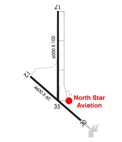
Airport Diagram might not be current. Facility Name: ULYSSES City Name: ULYSSES County: GRANT State abbrev: KS State Name: KANSAS Ownership: PUBLICLY OWNED Use: OPEN TO THE PUBLIC Owner's Name: GRANT COUNTY Address: 108 S GLENN ULYSSES, KS 67880 Owner's Phone: 620-356-1335 Manager's Name: STEVE RICE; DARREN FIGGINS CHMN ARPT BOARD PHONE 620-353-4137 & STEVE RICE NORTH STAR AVN INC; FBO 620-356-4528. Address: PO BOX 412 ULYSSES, KS 67880 Phone: 620-952-0954 FAA Region: CENTRAL FAA Field Office: NONE
Runway Identifications Help
Runway Identification: 12/30 Length: 4600 ftWidth: 60 ftSurface: CONCRETE-GOOD CONDITIONEdge lights: Medium Intensity Treatment: NONEWeight: PCN 7 /R/C/X/U Runway: 12 Runway: 30 Mag heading: 124° Mag heading: 304° Rwy Slope: -.20% Down Rwy Slope: .20% Up Approach: Approach: Pattern: Left Traffic Pattern: Left Traffic Markings: NONPRECISION INSTRUMENT Markings: NONPRECISION INSTRUMENT Marking Condition: GOOD Marking Condition: GOOD Arresting Dev: Arresting Dev: Lat & Long: N3736.2 W10122.8 Lat. & Long.: N3735.7 W10122.0 Elev: 3071.0 ft. MSL Elev: 3061.9 ft. MSL TCH: 38 ft. AGL TCH: 39 ft. AGL Visual Glide Path: 3.00 degrees Visual Glide Path: 3.00 degrees Displaced Threshold: No Displaced Threshold: No Touchdown Zone: YES Touchdown Zone: YES Touchdown Elev.: 3071.0 feet Touchdown Elev.: 3062.5 feet Visual Glide Slope: 2-Light PAPI on LEFT side of Runway Visual Glide Slope: 2-Light PAPI on LEFT side of Runway RVR Equipment: RVR Equipment: RVV Equipment: NO RVV Equipment: NO Approach Lights: Approach Lights: REIL: NO REIL: NO Centerline Lights: NO Centerline Lights: NO Touchdown lights: NO Touchdown lights: NO Runway Category: Runway with a Non-precision Approach having visibility minimums greater than 3/4 mile Runway Category: Runway with a Non-precision Approach having visibility minimums greater than 3/4 mile Declared Distances: Declared Distances: Obstructions: ROAD Obstructions: Marked: NOT Marked/Lighted Marked: Clearance slope: 30:1 Clearance slope: 50:1 Obstruction height: 16 feet AGL Obstruction height: Dist. from runway: 700 feet Dist. from runway: Centerline offset: Centerline offset: Comments: Comments:
Runway Identification: 17/35 Length: 6000 ftWidth: 100 ftSurface: CONCRETE-GOOD CONDITIONEdge lights: Medium Intensity Treatment: NONEWeight: PCN 19 /R/C/X/U Runway: 17 Runway: 35 Mag heading: 174° Mag heading: 354° Rwy Slope: -.08% Down Rwy Slope: .08% Up Approach: Approach: Pattern: Left Traffic Pattern: Left Traffic Markings: NONPRECISION INSTRUMENT Markings: NONPRECISION INSTRUMENT Marking Condition: GOOD Marking Condition: GOOD Arresting Dev: Arresting Dev: Lat & Long: N3737.0 W10122.4 Lat. & Long.: N3736.0 W10122.4 Elev: 3065.3 ft. MSL Elev: 3060.3 ft. MSL TCH: 40 ft. AGL TCH: 29 ft. AGL Visual Glide Path: 3.00 degrees Visual Glide Path: 3.00 degrees Displaced Threshold: No Displaced Threshold: No Touchdown Zone: YES Touchdown Zone: YES Touchdown Elev.: 3065.3 feet Touchdown Elev.: 3064.8 feet Visual Glide Slope: 4-Light PAPI on LEFT side of Runway Visual Glide Slope: 4-Light PAPI on LEFT side of Runway RVR Equipment: RVR Equipment: RVV Equipment: NO RVV Equipment: NO Approach Lights: Approach Lights: REIL: NO REIL: NO Centerline Lights: NO Centerline Lights: NO Touchdown lights: NO Touchdown lights: NO Runway Category: Runway with a Non-precision Approach having visibility minimums greater than 3/4 mile Runway Category: Runway with a Non-precision Approach having visibility minimums greater than 3/4 mile Declared Distances: Declared Distances: Obstructions: PLINE Obstructions: Marked: NOT Marked/Lighted Marked: Clearance slope: 30:1 Clearance slope: 50:1 Obstruction height: 40 feet AGL Obstruction height: Dist. from runway: 1400 feet Dist. from runway: Centerline offset: Centerline offset: Comments: Comments: