
| ||||||||||||||||||||||||||||||||||||||||||||
| ||||||||||||||||||||||||||||||||||||||||||||
| ||||||||||||||||||||||||||||||||||||||||||||
| ||||||||||||||||||||||||||||||||||||||||||||
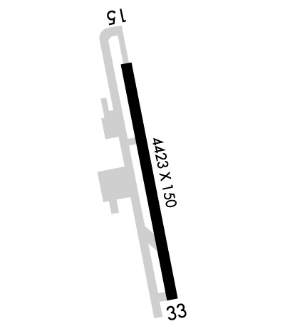
| Rwy | Rwy | |||||||
| 4423x150 | 4423' | 109.10 - 155° | 4423x150 | 4423' | ||||
| Runway ID | Single Wheel | Double Wheel | Double Tandem Wheel | Dual Double Wheel |
| 15/33 | 28,000 | N/A | N/A | N/A |
| These numbers are Advisory and are not limits. The Airport Manager should have more accurate Weight Limits | ||||
 Airport Diagram might not be current. | |
| Facility Name: | UKIAH MUNI |
| City Name: | UKIAH |
| County: | MENDOCINO |
| State abbrev: | CA |
| State Name: | CALIFORNIA |
| Ownership: | PUBLICLY OWNED |
| Use: | OPEN TO THE PUBLIC |
| Owner's Name: | CITY OF UKIAH |
| Address: | 300 SEMINARY AV |
| UKIAH, CA 95482 | |
| Owner's Phone: | 707-467-2855 |
| Manager's Name: | GREG OWEN |
| Address: | 1403 S. STATE STREET |
| UKIAH, CA 95482 | |
| Phone: | 707-467-2855 |
| FAA Region: | WESTERN-PACIFIC |
| FAA Field Office: | SFO |

| Date | Sunrise | Sunset |
|---|---|---|
| 04/18/24 Thursday | 6:31 | 19:54 |
| 04/19/24 Friday | 6:29 | 19:55 |
| 04/20/24 Saturday | 6:28 | 19:56 |
| 04/21/24 Sunday | 6:26 | 19:57 |
| 04/22/24 Monday | 6:25 | 19:58 |
| 04/23/24 Tuesday | 6:24 | 19:59 |
| 04/24/24 Wednesday | 6:22 | 20:00 |
| 04/25/24 Thursday | 6:21 | 20:01 |
| 04/26/24 Friday | 6:20 | 20:02 |
| 04/27/24 Saturday | 6:18 | 20:03 |
| 04/28/24 Sunday | 6:17 | 20:04 |
| 04/29/24 Monday | 6:16 | 20:05 |
| 04/30/24 Tuesday | 6:15 | 20:06 |
| 05/01/24 Wednesday | 6:13 | 20:07 |
| Airport Attendance Schedule | JUN SAT-SUN 0930-2000, JUL-AUG MON-FRI 0800-2030, JUL-AUG SAT-SUN 1000-2030, SEP MON-FRI 0800-2000, SEP SAT-SUN 0930-2000, OCT 7 Days A Week 0800-1930, NOV 7 Days A Week 0800-1800, DEC-APR 7 Days A Week 0800-1730, MAY MON-FRI 0800-1930, MAY SAT-SUN 0930-1930 |
| Airport Status | OPERATIONAL (This Status can change at any time - please check NOTAMS) |
| Airport Lighting Schedule | ACTVT PAPI RWY 15; REIL RWY 15 & 33; MIRL RWY 15/33 - CTAF.; DUSK-DAWN |
| Airport Storage Available | Tie Downs |
| Extra Services Available | Air Ambulance, Charter, Flight Instruction, Aircraft Rental, Aircraft Sales |
| Wind Indicator | YES - (lighted) |
| Control Tower | NO |
| CTAF Frequency | 123.000 |
| Unicom Frequency | 123.000 |
| Rotating Beacon Color | WG; SECOND ROTATING BCN ON MTN 250 DEGREES MAGNETIC & 2 MILES FM ARPT. |
| Segmented Circle | YES |
| Landing Fee | YES; LNDG FEE FOR ALL ACFT OVR 12500 LBS. |
| Airport Inspected | STATE - performed by STATE AERONAUTICAL PERSONNEL |
| Inspection Date | 09/30/2022 |
| Type of Fuel Available | Grade 100LL, JET A (freeze point -40C); -10SELF-SERVICE FUEL AVBL. |
| Airframe Repair Service | MAJOR |
| Power Plant Repair Service | MAJOR |
| Latitude | N3907.6 |
| Longitude | W12312.1 (ESTIMATED) |
| Arpt Elevation | 616ft (SURVEYED) |
| Magnetic Variation | 13E |
| 1 miles S | of UKIAH |
| Traffic Pattern Altitude | |
| Sectional Chart | SAN FRANCISCO |
| Operations (Reported) | Yearly | Avg. Daily |
|---|---|---|
| General Aviation Transient | 25000 | 68 |
| General Aviation Local | 15000 | 41 |
| Air Taxi | 3000 | 8 |
| Commerical | 0 | 0 |
| Commuter | 0 | 0 |
| Military | 300 | 1 |
| Aircraft based on Field | |
|---|---|
| General Aviation Singles | 60 |
| General Aviation Multi | 2 |
| Jet Aircraft | 0 |
| General Aviation Helicopters | 2 |
| Military Aircraft | 0 |
| Gliders | 1 |
| Ultralights | 0 |
| FSS on field | NO |
| FSS tie-in | OAKLAND |
| FSS Phone | 1-800-WX-BRIEF |
| Who issues Notams | UKI |
| Notam D service at airport | YES |
| ARTCC Name | OAKLAND |
| Airport Certification | |
| Aircraft Rescue & Firefighting Index | None |
| Airport of Entry | No |
| Custom Landing Rights | No |
| Joint Civil/Military | No |
| Military Landing rights | YES |
| NATIONAL PLAN OF INTEGRATED AIRPORT SYSTEMS (NPIAS) |
| GRANT AGREEMENTS UNDER FAAP/ADAP/AIP |
| ASSURANCES PURSUANT TO TITLE VI, CIVIL RIGHTS ACT OF 1964 |
| NOISE ABATEMENT PROCEDURES: AMGR REQUESTS NO VFR STRAIGHT-IN APCHS TO RY 15/33, RIGHT TURN AFTER DEP RY 33 TO AVOID OVERFLIGHT OF TOWN. |
| FOR CD IF UNA TO CTC ON FSS FREQ, CTC OAKLAND ARTCC AT 510-745-3380. |
Airport Communications & Frequencies:
| |||||||||
| Runway: 15 | Runway: 33 | ||
| Mag heading: | 155° | Mag heading: | 335° |
| Rwy Slope: | -.27% Down | Rwy Slope: | .27% Up |
| Approach: | LOC/DME | Approach: | |
| Pattern: | Left Traffic | Pattern: | Right Traffic |
| Markings: | NONPRECISION INSTRUMENT | Markings: | BASIC |
| Marking Condition: | GOOD | Marking Condition: | GOOD |
| Arresting Dev: | Arresting Dev: | ||
| Lat & Long: | N3907.9 W12312.1 | Lat. & Long.: | N3907.2 W12312.0 |
| Elev: | 616.8 ft. MSL | Elev: | 604.7 ft. MSL |
| TCH: | 29 ft. AGL | TCH: | |
| Visual Glide Path: | 3.00 degrees | Visual Glide Path: | |
| Displaced Threshold: | No | Displaced Threshold: | No |
| Touchdown Zone: | YES | Touchdown Zone: | YES |
| Touchdown Elev.: | 616.8 feet | Touchdown Elev.: | 612.1 feet |
| Visual Glide Slope: | 4-Light PAPI on LEFT side of Runway | Visual Glide Slope: | |
| RVR Equipment: | RVR Equipment: | ||
| RVV Equipment: | NO | RVV Equipment: | NO |
| Approach Lights: | Approach Lights: | ||
| REIL: | YES | REIL: | YES |
| Centerline Lights: | NO | Centerline Lights: | NO |
| Touchdown lights: | NO | Touchdown lights: | NO |
| Runway Category: | Runway with a Non-precision Approach having visibility minimums greater than 3/4 mile | Runway Category: | Runway with a Visual Approach |
| Declared Distances: | Declared Distances: | ||
| Obstructions: | TREES | Obstructions: | TREES |
| Marked: | NOT Marked/Lighted | Marked: | NOT Marked/Lighted |
| Clearance slope: | 27:1 | Clearance slope: | 18:1 |
| Obstruction height: | 27 feet AGL | Obstruction height: | 27 feet AGL |
| Dist. from runway: | 950 feet | Dist. from runway: | 700 feet |
| Centerline offset: | 190 right of centerline | Centerline offset: | 135 feet left of centerline |
| Comments: | Comments: |