Current Weather/Notams (Metars, TAFs, Notams, NWS Forecast, PIREPS, and nearby weather)
Customs Information Send updates to Support@FltPlan.com
Customs Not Available
Database effective 04/18/2024
Airport Diagram might not be current.
|
| Facility Name: | QUINCY RGNL-BALDWIN FLD |
| City Name: | QUINCY |
| County: | ADAMS |
| State abbrev: | IL |
| State Name: | ILLINOIS |
| | |
| Ownership: | PUBLICLY OWNED |
| Use: | OPEN TO THE PUBLIC |
| Owner's Name: | CITY OF QUINCY |
| Address: | 1645 HWY 104 |
| | QUINCY, IL 62305 |
| Owner's Phone: | 217-885-3285; EXT: 8. |
| | |
| Manager's Name: | CHUCK MILLER; EMAIL ADDRESS: QUINCYAIRPORT@QUINCYIL.GOV |
| Address: | 1645 HWY 104 |
| | QUINCY, IL 62305 |
| Phone: | 217-885-3285 |
| | |
| FAA Region: | GREAT LAKES |
| FAA Field Office: | CHI |
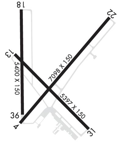
Runway Identifications
Runway Identification: 04/22Length: 7098 ft
Width: 150 ft
Surface: ASPHALT-FAIR CONDITION
Edge lights: High IntensityTreatment: GROOVED
Weight: PCN 71 /R/C/X/T
| | Runway: 04 | | Runway: 22 |
| Mag heading: | 38° | Mag heading: | 218° |
| Rwy Slope: | -.13% Down | Rwy Slope: | .13% Up |
| Approach: | ILS | Approach: | |
| Pattern: | Left Traffic | Pattern: | Left Traffic |
| Markings: | PRECISION INSTRUMENT | Markings: | PRECISION INSTRUMENT |
| Marking Condition: | GOOD | Marking Condition: | GOOD |
| Arresting Dev: | | Arresting Dev: | |
| Lat & Long: | N3956.2 W09112.0 | Lat. & Long.: | N3957.1 W09111.0 |
| Elev: | 755.7 ft. MSL | Elev: | 746.4 ft. MSL |
| TCH: | 42 ft. AGL | TCH: | 46 ft. AGL |
| Visual Glide Path: | 3.00 degrees | Visual Glide Path: | 3.00 degrees |
| Displaced Threshold: | No | Displaced Threshold: | No |
| Touchdown Zone: | YES | Touchdown Zone: | YES |
| Touchdown Elev.: | 759.5 feet | Touchdown Elev.: | 746.8 feet |
| Visual Glide Slope: | 4-Light PAPI on RIGHT side of Runway | Visual Glide Slope: | 4-Light PAPI on LEFT side of Runway |
| RVR Equipment: | | RVR Equipment: | |
| RVV Equipment: | YES | RVV Equipment: | NO |
| Approach Lights: | MALSR - 1,400 foot medium intensity approach lighting system with runway alignment indicator lights | Approach Lights: | |
| REIL: | NO | REIL: | YES |
| Centerline Lights: | NO | Centerline Lights: | NO |
| Touchdown lights: | NO | Touchdown lights: | NO |
| Runway Category: | Precision Instrument Runway | Runway Category: | Runway with a Non-precision Approach having visibility minimums greater than 3/4 mile |
| Declared Distances: | TORA:7098' TODA:7098' ASDA:7098' LDA:7098' | Declared Distances: | TORA:7098' TODA:7098' ASDA:7098' LDA:7098' |
| Obstructions: | ROAD | Obstructions: | |
| Marked: | NOT Marked/Lighted | Marked: | |
| Clearance slope: | 40:1 | Clearance slope: | 50:1 |
| Obstruction height: | 16 feet AGL | Obstruction height: | |
| Dist. from runway: | 848 feet | Dist. from runway: | |
| Centerline offset: | 586 right of centerline | Centerline offset: | |
| Comments: | | Comments: | |
Runway Identification: 13/31Length: 5397 ft
Width: 150 ft
Surface: ASPHALT-FAIR CONDITION
Edge lights: Medium IntensityTreatment: GROOVED
Weight: PCN 71 /R/C/X/T
| | Runway: 13 | | Runway: 31 |
| Mag heading: | 133° | Mag heading: | 313° |
| Rwy Slope: | .06% Up | Rwy Slope: | -.06% Down |
| Approach: | | Approach: | |
| Pattern: | Left Traffic | Pattern: | Left Traffic |
| Markings: | NONPRECISION INSTRUMENT | Markings: | NONPRECISION INSTRUMENT |
| Marking Condition: | GOOD | Marking Condition: | GOOD |
| Arresting Dev: | | Arresting Dev: | |
| Lat & Long: | N3956.8 W09112.0 | Lat. & Long.: | N3956.1 W09111.2 |
| Elev: | 765.3 ft. MSL | Elev: | 768.7 ft. MSL |
| TCH: | 33 ft. AGL | TCH: | 40 ft. AGL |
| Visual Glide Path: | 3.00 degrees | Visual Glide Path: | 3.00 degrees |
| Displaced Threshold: | No | Displaced Threshold: | No |
| Touchdown Zone: | YES | Touchdown Zone: | YES |
| Touchdown Elev.: | 766.8 feet | Touchdown Elev.: | 768.7 feet |
| Visual Glide Slope: | 4-Light PAPI on LEFT side of Runway; PAPI UNUSBL BYD 9 DEGS RIGHT OF CNTRLN. | Visual Glide Slope: | 4-Light PAPI on RIGHT side of Runway |
| RVR Equipment: | | RVR Equipment: | |
| RVV Equipment: | NO | RVV Equipment: | NO |
| Approach Lights: | | Approach Lights: | |
| REIL: | NO | REIL: | NO |
| Centerline Lights: | NO | Centerline Lights: | NO |
| Touchdown lights: | NO | Touchdown lights: | NO |
| Runway Category: | Runway with a Non-precision Approach having visibility minimums greater than 3/4 mile | Runway Category: | Runway with a Non-precision Approach having visibility minimums greater than 3/4 mile |
| Declared Distances: | TORA:5397' TODA:5397' ASDA:5123' LDA:5123' | Declared Distances: | TORA:5397' TODA:5397' ASDA:5146' LDA:5146' |
| Obstructions: | ROAD | Obstructions: | POLE |
| Marked: | NOT Marked/Lighted | Marked: | NOT Marked/Lighted |
| Clearance slope: | 29:1 | Clearance slope: | 40:1 |
| Obstruction height: | 11 feet AGL | Obstruction height: | 15 feet AGL |
| Dist. from runway: | 525 feet | Dist. from runway: | 800 feet |
| Centerline offset: | 300 right of centerline | Centerline offset: | 200 feet left of centerline |
| Comments: | | Comments: | |

