Click here for more info on on SMS!

KUIL

QUILLAYUTE
QUILLAYUTE
WA
Time Zone: Pacific
Lat: N 4756.2
Long: W 12433.8
Elev: 194
Var: -21
Longest Runway: 4211
AWOS: 135.22
CTAF: 122.9

FBO & Flight Services info for KUIL

FBOs: Update your Fuel Prices

AIRPORTPh: 360-374-5412
-
Freq: 122.9
Service
Jet
100LL
SAF
MoGas
Fuel Avail: NO FUEL AVAILABLE
Full        Last Update: 04/19/2024 00:01:45

Self        
ASOSPh: 360-374-9731
-
Freq: 135.22  
If you are an FBO, call 1-203-262-1700 to update your info or email: FltPlan.Advertising@garmin.com
Advertise your FBO on FltPlan.com

Runway & Approach Info for KUIL
Rwy
Length
Land Dist**
Approach*
  Rwy
Length
Land Dist**
Approach*
04
4211x100  4211'          
 
  
22
  4211x100  4211'          
 
 * only ILS, LOC, LDA, and SDF approaches to a specific runway are shown
** For any Declared Landing Distance Available, please see A/FD or Approach plates
Runway Weight Capability (lbs.) Help
Runway IDSingle WheelDouble WheelDouble Tandem WheelDual Double Wheel
04/2230,00050,000N/AN/A
These numbers are Advisory and are not limits.   The Airport Manager should have more accurate Weight Limits
Approach Charts
FltPlan does not have IFR approach charts available for KUIL.
Current Weather/Notams
Customs Information Send updates to Support@FltPlan.com
Customs Not Available
Database effective 04/18/2024
Airport Diagram of KUIL
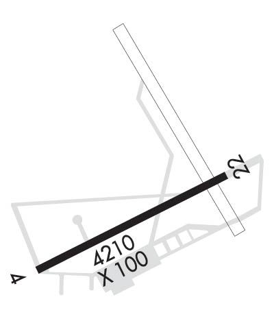
Airport Diagram might not be current.

Facility Name: QUILLAYUTE
City Name: QUILLAYUTE
County: CLALLAM
State abbrev: WA
State Name: WASHINGTON
   
Ownership: PUBLICLY OWNED
Use: OPEN TO THE PUBLIC
Owner's Name: CITY OF FORKS
Address: 500 EAST DIVISION ST.
 FORKS, WA 98331
Owner's Phone: 360-374-5412; EXT 245.
  
Manager's Name: ROD FLECK
Address: 500 EAST DIVISION ST.
 FORKS, WA 98331
Phone: 360-374-5412
   
FAA Region: NORTHWEST MOUNTAIN
FAA Field Office: SEA


Sunrise / Sunset times for QUILLAYUTE

DateSunriseSunset
04/18/24 Thursday6:2220:14
04/19/24 Friday6:2020:15
04/20/24 Saturday6:1820:17
04/21/24 Sunday6:1620:18
04/22/24 Monday6:1420:20
04/23/24 Tuesday6:1220:21
04/24/24 Wednesday6:1120:23
04/25/24 Thursday6:0920:24
04/26/24 Friday6:0720:25
04/27/24 Saturday6:0520:27
04/28/24 Sunday6:0420:28
04/29/24 Monday6:0220:30
04/30/24 Tuesday6:0020:31
05/01/24 Wednesday5:5920:32

Airport Facilities

Airport Attendance ScheduleUNATTENDED
Airport Status OPERATIONAL (This Status can change at any time - please check NOTAMS)
Airport Lighting Schedule
Airport Storage AvailableTie Downs
Extra Services AvailableNONE
Wind IndicatorYES - (unlit)
Control TowerNO
CTAF Frequency122.900
Unicom Frequency
Rotating Beacon Color
Segmented CircleYES
Landing FeeNO

Airport Inspection Data

Airport InspectedSTATE - performed by STATE AERONAUTICAL PERSONNEL
Inspection Date08/02/2023

Airport Services

Type of Fuel AvailableNone
Airframe Repair ServiceNONE
Power Plant Repair ServiceNONE

Geographic Data

LatitudeN4756.2
LongitudeW12433.8 (ESTIMATED)
Arpt Elevation194ft (SURVEYED)
Magnetic Variation21E
7 miles Eof QUILLAYUTE
Traffic Pattern Altitude
Sectional ChartSEATTLE

Aircraft Data

Operations (Reported)YearlyAvg. Daily
General Aviation Transient 33029
General Aviation Local 31989
Air Taxi 00
Commerical 00
Commuter 00
Military 2001
Aircraft based on Field
General Aviation Singles 0
General Aviation Multi 0
Jet Aircraft 0
General Aviation Helicopters 0
Military Aircraft 0
Gliders 0
Ultralights 0

FAA Services

FSS on field NO
FSS tie-in SEATTLE
FSS Phone 1-800-WX-BRIEF
Who issues Notams UIL
Notam D service at airport YES
ARTCC Name SEATTLE

Federal Status

Airport Certification
Aircraft Rescue & Firefighting IndexNone
Airport of EntryNo
Custom Landing RightsNo
Joint Civil/MilitaryNo
Military Landing rightsYES

Federal Agreements

NATIONAL PLAN OF INTEGRATED AIRPORT SYSTEMS (NPIAS)
SURPLUS PROPERTY AGREEMENT UNDER PUBLIC LAW 289

Remarks

PEDESTRIANS; VEHICLES & ANIMALS ON & INVOF RY.
4 FT SQUARE GRATED DRAIN ON N SIDE OF APRON.
FOR CD CTC SEATTLE ARTCC AT 253-351-3694.
Runway Identifications
Runway Identification: 04/22
Length: 4211 ft
Width: 100 ft
Surface: CONCRETE-GOOD CONDITION
Edge lights:

Treatment: NONE

 Runway: 04   Runway: 22
Mag heading: 37°Mag heading: 217°
Rwy Slope: .42% UpRwy Slope: -.42% Down
Approach: Approach:
Pattern: Left TrafficPattern: Left Traffic
Markings: BASICMarkings: BASIC
Marking Condition: FAIRMarking Condition: FAIR
Arresting Dev: Arresting Dev:
Lat & Long: N4756.0  W12434.2Lat. & Long.: N4756.4  W12433.3
Elev: 176.4 ft. MSLElev: 194.1 ft. MSL
TCH: TCH:
Visual Glide Path: Visual Glide Path:
Displaced Threshold: NoDisplaced Threshold: No
Touchdown Zone: YESTouchdown Zone: YES
Touchdown Elev.: 187.3 feetTouchdown Elev.: 194.1 feet
Visual Glide Slope: Visual Glide Slope:
RVR Equipment: RVR Equipment:
RVV Equipment: NORVV Equipment: NO
Approach Lights: Approach Lights:
REIL: NOREIL: NO
Centerline Lights: NOCenterline Lights: NO
Touchdown lights: NOTouchdown lights: NO
Runway Category: Runway with a Visual ApproachRunway Category: Runway with a Visual Approach
Declared Distances: Declared Distances:
Obstructions: TREESObstructions:
Marked: NOT Marked/LightedMarked:
Clearance slope: 19:1Clearance slope: 20:1
Obstruction height: 70 feet AGLObstruction height:
Dist. from runway: 1535 feetDist. from runway:
Centerline offset: Centerline offset:
Comments: Comments:
C:/P: