Current Weather/Notams (Metars, TAFs, Notams, NWS Forecast, PIREPS, and nearby weather)
Customs Information Send updates to Support@FltPlan.com
Phone 224-529-1468
Fax 224-287-1642
Comments Mon-Fri 1100-1900 *2 hrs advance notice required 3 hrs after hours *Maximum passengers per flight: 15 *M-F Call prior to 1900 on precceding weekday *WKND Call prior to 1900 on preceeding Friday. Email waukegannationalairport@cbp.dhs.gov
Database effective 05/16/2024
Airport Diagram might not be current.
|
| Facility Name: | WAUKEGAN NTL |
| City Name: | CHICAGO/WAUKEGAN |
| County: | LAKE |
| State abbrev: | IL |
| State Name: | ILLINOIS |
| | |
| Ownership: | PUBLICLY OWNED |
| Use: | OPEN TO THE PUBLIC |
| Owner's Name: | WAUKEGAN PORT DISTRICT |
| Address: | PO BOX 620 |
| | WAUKEGAN, IL 60079 |
| Owner's Phone: | 847-244-0055 |
| | |
| Manager's Name: | SKIP GOSS |
| Address: | 2601 PLANE REST DRIVE; EMAIL ADDRESS: SGOSS@WAUKEGANPORT.COM |
| | WAUKEGAN, IL 60087 |
| Phone: | 847-244-0055 |
| | |
| FAA Region: | GREAT LAKES |
| FAA Field Office: | CHI |
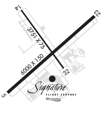
Runway Identifications
Runway Identification: 05/23Length: 6001 ft
Width: 150 ft
Surface: ASPHALT-GOOD CONDITION
Edge lights: High IntensityTreatment: GROOVED
| | Runway: 05 | | Runway: 23 |
| Mag heading: | 51° | Mag heading: | 231° |
| Rwy Slope: | -.04% Down | Rwy Slope: | .04% Up |
| Approach: | | Approach: | ILS |
| Pattern: | Left Traffic | Pattern: | Right Traffic |
| Markings: | PRECISION INSTRUMENT | Markings: | PRECISION INSTRUMENT |
| Marking Condition: | GOOD | Marking Condition: | GOOD |
| Arresting Dev: | | Arresting Dev: | |
| Lat & Long: | N4225.0 W08752.5 | Lat. & Long.: | N4225.6 W08751.5 |
| Elev: | 725.8 ft. MSL | Elev: | 723.4 ft. MSL |
| TCH: | 35 ft. AGL | TCH: | 52 ft. AGL |
| Visual Glide Path: | 3.00 degrees | Visual Glide Path: | 3.00 degrees |
| Displaced Threshold: | No | Displaced Threshold: | No |
| Touchdown Zone: | YES | Touchdown Zone: | YES |
| Touchdown Elev.: | 725.8 feet | Touchdown Elev.: | 723.5 feet |
| Visual Glide Slope: | 4-BOX VASI ON LEFT SIDE OF RUNWAY | Visual Glide Slope: | 4-BOX VASI ON LEFT SIDE OF RUNWAY |
| RVR Equipment: | | RVR Equipment: | |
| RVV Equipment: | NO | RVV Equipment: | NO |
| Approach Lights: | | Approach Lights: | MALSR - 1,400 foot medium intensity approach lighting system with runway alignment indicator lights |
| REIL: | YES | REIL: | NO |
| Centerline Lights: | NO | Centerline Lights: | NO |
| Touchdown lights: | NO | Touchdown lights: | NO |
| Runway Category: | Runway with a Non-precision Approach having visibility minimums greater than 3/4 mile | Runway Category: | Precision Instrument Runway |
| Declared Distances: | | Declared Distances: | |
| Obstructions: | ROAD | Obstructions: | TREE |
| Marked: | NOT Marked/Lighted | Marked: | NOT Marked/Lighted |
| Clearance slope: | 6:1 | Clearance slope: | 27:1 |
| Obstruction height: | 12 feet AGL | Obstruction height: | 34 feet AGL |
| Dist. from runway: | 281 feet | Dist. from runway: | 1090 feet |
| Centerline offset: | 502 left of centerline | Centerline offset: | 419 feet right of centerline |
| Comments: | | Comments: | |
Runway Identification: 14/32Length: 3750 ft
Width: 75 ft
Surface: ASPHALT-GOOD CONDITION
Edge lights: Medium IntensityTreatment: NONE
| | Runway: 14 | | Runway: 32 |
| Mag heading: | 147° | Mag heading: | 327° |
| Rwy Slope: | -.42% Down | Rwy Slope: | .42% Up |
| Approach: | | Approach: | |
| Pattern: | Left Traffic | Pattern: | Left Traffic |
| Markings: | BASIC | Markings: | BASIC |
| Marking Condition: | GOOD | Marking Condition: | GOOD |
| Arresting Dev: | | Arresting Dev: | |
| Lat & Long: | N4225.7 W08752.4 | Lat. & Long.: | N4225.2 W08751.9 |
| Elev: | 727.9 ft. MSL | Elev: | 712.0 ft. MSL |
| TCH: | 30 ft. AGL | TCH: | |
| Visual Glide Path: | 3.50 degrees | Visual Glide Path: | |
| Displaced Threshold: | 489 feet | Displaced Threshold: | No |
| Touchdown Zone: | YES | Touchdown Zone: | YES |
| Touchdown Elev.: | 728.1 feet | Touchdown Elev.: | 727.3 feet |
| Visual Glide Slope: | 4-BOX VASI ON LEFT SIDE OF RUNWAY | Visual Glide Slope: | |
| RVR Equipment: | | RVR Equipment: | |
| RVV Equipment: | NO | RVV Equipment: | NO |
| Approach Lights: | | Approach Lights: | |
| REIL: | NO | REIL: | NO |
| Centerline Lights: | NO | Centerline Lights: | NO |
| Touchdown lights: | NO | Touchdown lights: | NO |
| Runway Category: | Runway with a Visual Approach | Runway Category: | Runway with a Visual Approach |
| Declared Distances: | | Declared Distances: | |
| Obstructions: | ROAD | Obstructions: | |
| Marked: | NOT Marked/Lighted | Marked: | |
| Clearance slope: | 1:1; APCH RATIO IS 26:1 AT DSPLCD THLD. | Clearance slope: | 20:1 |
| Obstruction height: | 29 feet AGL | Obstruction height: | |
| Dist. from runway: | 205 feet | Dist. from runway: | |
| Centerline offset: | 125 left of centerline | Centerline offset: | |
| Comments: | | Comments: | |