Current Weather/Notams (Metars, TAFs, Notams, NWS Forecast, PIREPS, and nearby weather)
Customs Information Send updates to Support@FltPlan.com
Customs Not Available
Database effective 04/18/2024
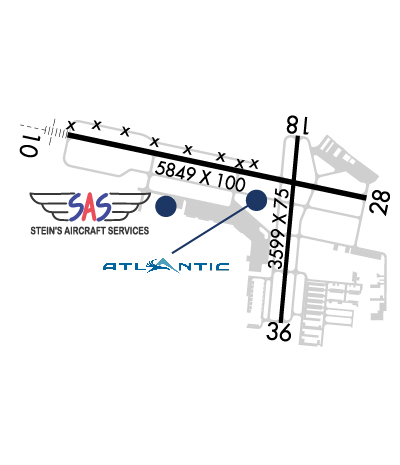
Airport Diagram might not be current. Facility Name: WAUKESHA COUNTY City Name: WAUKESHA County: WAUKESHA State abbrev: WI State Name: WISCONSIN Ownership: PUBLICLY OWNED Use: OPEN TO THE PUBLIC Owner's Name: WAUKESHA COUNTY Address: 515 W MOORLAND BLVD WAUKESHA, WI 53188 Owner's Phone: 262-548-7010 Manager's Name: KURT STANICH Address: 2525 AVIATION DR; EMAIL ADDRESS: KSTANICH@WAUKESHACOUNTY.GOV (ALL LOWER CASE) WAUKESHA, WI 53188 Phone: 262-521-5250; CELL PHONE: 262-424-6747 FAA Region: GREAT LAKES FAA Field Office: CHI
Runway Identifications Help
Runway Identification: 10/28 Length: 5849 ftWidth: 100 ftSurface: CONCRETEEdge lights: High Intensity Treatment: GROOVED Runway: 10 Runway: 28 Mag heading: 103° Mag heading: 283° Rwy Slope: .15% Up Rwy Slope: -.15% Down Approach: ILS Approach: Pattern: Left Traffic Pattern: Right Traffic Markings: PRECISION INSTRUMENT Markings: PRECISION INSTRUMENT Marking Condition: GOOD Marking Condition: GOOD Arresting Dev: Arresting Dev: Lat & Long: N4302.6 W08815.0 Lat. & Long.: N4302.4 W08813.7 Elev: 897.2 ft. MSL Elev: 906.1 ft. MSL TCH: 53 ft. AGL TCH: 37 ft. AGL Visual Glide Path: 3.00 degrees Visual Glide Path: 3.75 degrees Displaced Threshold: No Displaced Threshold: No Touchdown Zone: YES Touchdown Zone: YES Touchdown Elev.: 900.8 feet Touchdown Elev.: 906.1 feet Visual Glide Slope: 4-Light PAPI on RIGHT side of Runway Visual Glide Slope: 4-BOX VASI ON LEFT SIDE OF RUNWAY RVR Equipment: RVR Equipment: RVV Equipment: NO RVV Equipment: NO Approach Lights: MALSR - 1,400 foot medium intensity approach lighting system with runway alignment indicator lights Approach Lights: REIL: NO REIL: YES Centerline Lights: NO Centerline Lights: NO Touchdown lights: NO Touchdown lights: NO Runway Category: Precision Instrument Runway Runway Category: Runway with a Non-precision Approach having visibility minimums greater than 3/4 mile Declared Distances: Declared Distances: Obstructions: TREES Obstructions: TREES Marked: NOT Marked/Lighted Marked: NOT Marked/Lighted Clearance slope: 36:1 Clearance slope: 17:1 Obstruction height: 243 feet AGL Obstruction height: 80 feet AGL Dist. from runway: 8930 feet Dist. from runway: 1590 feet Centerline offset: 1100 right of centerline Centerline offset: 100 feet left of centerline Comments: Comments:
Runway Identification: 18/36 Length: 3599 ftWidth: 75 ftSurface: ASPHALT-FAIR CONDITIONEdge lights: Medium Intensity Treatment: NONE Runway: 18 Runway: 36 Mag heading: 186° Mag heading: 6° Rwy Slope: .14% Up Rwy Slope: -.14% Down Approach: Approach: Pattern: Left Traffic Pattern: Right Traffic Markings: NONPRECISION INSTRUMENT Markings: NONPRECISION INSTRUMENT Marking Condition: FAIR Marking Condition: FAIR Arresting Dev: Arresting Dev: Lat & Long: N4302.6 W08814.0 Lat. & Long.: N4302.0 W08814.1 Elev: 906.3 ft. MSL Elev: 911.5 ft. MSL TCH: 27 ft. AGL TCH: 26 ft. AGL Visual Glide Path: 3.00 degrees Visual Glide Path: 4.00 degrees Displaced Threshold: No Displaced Threshold: No Touchdown Zone: YES Touchdown Zone: YES Touchdown Elev.: 906.3 feet Touchdown Elev.: 911.5 feet Visual Glide Slope: 2-Light PAPI on LEFT side of Runway Visual Glide Slope: 2-Light PAPI on LEFT side of Runway RVR Equipment: RVR Equipment: RVV Equipment: NO RVV Equipment: NO Approach Lights: Approach Lights: REIL: YES REIL: YES Centerline Lights: NO Centerline Lights: NO Touchdown lights: NO Touchdown lights: NO Runway Category: Runway with a Visual Approach Runway Category: Runway with a Visual Approach Declared Distances: Declared Distances: Obstructions: Obstructions: TREE Marked: Marked: NOT Marked/Lighted Clearance slope: 20:1 Clearance slope: 14:1 Obstruction height: Obstruction height: 39 feet AGL Dist. from runway: Dist. from runway: 750 feet Centerline offset: Centerline offset: 170 feet right of centerline Comments: Comments: