Approach Charts
| FltPlan does not have IFR approach charts available for KU78. |
Current Weather/Notams (Metars, TAFs, Notams, NWS Forecast, PIREPS, and nearby weather)
Customs Information Send updates to Support@FltPlan.com
Customs Not Available
Database effective 05/16/2024
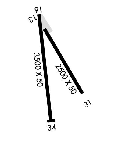
Airport Diagram might not be current.
|
| Facility Name: | ALLEN H TIGERT |
| City Name: | SODA SPRINGS |
| County: | CARIBOU |
| State abbrev: | ID |
| State Name: | IDAHO |
| | |
| Ownership: | PUBLICLY OWNED |
| Use: | OPEN TO THE PUBLIC |
| Owner's Name: | CITY OF SODA SPRINGS |
| Address: | 9 WEST 2ND SOUTH |
| | SODA SPRINGS, ID 83276 |
| Owner's Phone: | 208-547-2600 |
| | |
| Manager's Name: | ALAN SKINNER |
| Address: | 9 WEST 2ND SOUTH |
| | SODA SPRINGS, ID 83276 |
| Phone: | 208-547-2600 |
| | |
| FAA Region: | NORTHWEST MOUNTAIN |
| FAA Field Office: | HLN |
Runway Identifications
Runway Identification: 13/31Length: 2500 ft
Width: 50 ft
Surface: ASPHALT-POOR CONDITION
Edge lights: Treatment: NONE
| | Runway: 13 | | Runway: 31 |
| Mag heading: | N/A | Mag heading: | N/A |
| Rwy Slope: | .36% Up | Rwy Slope: | -.36% Down |
| Approach: | | Approach: | |
| Pattern: | Left Traffic | Pattern: | Left Traffic |
| Markings: | NONE | Markings: | NONE |
| Marking Condition: | | Marking Condition: | |
| Arresting Dev: | | Arresting Dev: | |
| Lat & Long: | N4239.1 W11135.0 | Lat. & Long.: | N4238.7 W11134.7 |
| Elev: | 5834.0 ft. MSL | Elev: | 5843.0 ft. MSL |
| TCH: | | TCH: | |
| Visual Glide Path: | | Visual Glide Path: | |
| Displaced Threshold: | No | Displaced Threshold: | No |
| Touchdown Zone: | NO | Touchdown Zone: | NO |
| Touchdown Elev.: | | Touchdown Elev.: | |
| Visual Glide Slope: | | Visual Glide Slope: | |
| RVR Equipment: | | RVR Equipment: | |
| RVV Equipment: | NO | RVV Equipment: | NO |
| Approach Lights: | | Approach Lights: | |
| REIL: | NO | REIL: | NO |
| Centerline Lights: | NO | Centerline Lights: | NO |
| Touchdown lights: | NO | Touchdown lights: | NO |
| Runway Category: | Runway with a Visual Approach | Runway Category: | Runway with a Visual Approach |
| Declared Distances: | | Declared Distances: | |
| Obstructions: | POLE | Obstructions: | PLINE |
| Marked: | NOT Marked/Lighted | Marked: | NOT Marked/Lighted |
| Clearance slope: | 5:1 | Clearance slope: | 9:1 |
| Obstruction height: | 45 feet AGL | Obstruction height: | 40 feet AGL |
| Dist. from runway: | 450 feet | Dist. from runway: | 600 feet |
| Centerline offset: | 50 left of centerline | Centerline offset: | |
| Comments: | +12' PARKED ACFT AT 0' 115' L. | Comments: | +9' ROAD AT 60' ON CNTRLN. |
Runway Identification: 16/34Length: 3500 ft
Width: 50 ft
Surface: ASPHALT-POOR CONDITION
Edge lights: Non-Standard Lighting SystemTreatment: NONE
| | Runway: 16 | | Runway: 34 |
| Mag heading: | N/A | Mag heading: | N/A |
| Rwy Slope: | .29% Up | Rwy Slope: | -.29% Down |
| Approach: | | Approach: | |
| Pattern: | Left Traffic | Pattern: | Left Traffic |
| Markings: | BASIC | Markings: | BASIC |
| Marking Condition: | POOR; MARKINGS ARE VERY DFCLT TO SEE - PAINT IS ALMOST ALL GONE. | Marking Condition: | POOR; MARKINGS ARE VERY DFCLT TO SEE - PAINT IS ALMOST ALL GONE. |
| Arresting Dev: | | Arresting Dev: | |
| Lat & Long: | N4239.2 W11135.0 | Lat. & Long.: | N4238.6 W11134.9 |
| Elev: | 5833.0 ft. MSL | Elev: | 5843.0 ft. MSL |
| TCH: | 25 ft. AGL | TCH: | 44 ft. AGL |
| Visual Glide Path: | 4.00 degrees | Visual Glide Path: | 3.00 degrees |
| Displaced Threshold: | 300 feet; DTHR 300 FT AT NIGHT. | Displaced Threshold: | No |
| Touchdown Zone: | NO | Touchdown Zone: | NO |
| Touchdown Elev.: | | Touchdown Elev.: | |
| Visual Glide Slope: | TRI-COLOR VASI ON LEFT SIDE OF RUNWAY; TRI COLOR VASI INOPERABLE INDEFINITELY | Visual Glide Slope: | TRI-COLOR VASI ON LEFT SIDE OF RUNWAY; TRI COLOR VASI INOPERABLE INDEFINITELY |
| RVR Equipment: | | RVR Equipment: | |
| RVV Equipment: | NO | RVV Equipment: | NO |
| Approach Lights: | | Approach Lights: | |
| REIL: | NO | REIL: | NO |
| Centerline Lights: | NO | Centerline Lights: | NO |
| Touchdown lights: | NO | Touchdown lights: | NO |
| Runway Category: | Runway with a Visual Approach | Runway Category: | Runway with a Visual Approach |
| Declared Distances: | | Declared Distances: | |
| Obstructions: | ROAD; +100' BARN/GRAIN ELEVATOR AT 1000', 400'L. | Obstructions: | |
| Marked: | NOT Marked/Lighted | Marked: | |
| Clearance slope: | 31:1 FM DSPLCD THR. | Clearance slope: | 50:1 |
| Obstruction height: | 16 feet AGL | Obstruction height: | |
| Dist. from runway: | 200 feet | Dist. from runway: | |
| Centerline offset: | 100 right of centerline | Centerline offset: | |
| Comments: | +16' HWY CROSSES PRIM SFC 50' FM EOR; NUMEROUS HIGH VEHICLES; NUMEROUS CLOSE IN OBSTNS ON APCH TO RY 16. | Comments: | |

