
| |||||||||||||||||||||||||||||||||||||||||||||||||||||||||||||
| |||||||||||||||||||||||||||||||||||||||||||||||||||||||||||||
| Rwy | Rwy | |||||||
| 5000x75 | 5000' | 5000x75 | 5000' | |||||
| Runway ID | Single Wheel | Double Wheel | Double Tandem Wheel | Dual Double Wheel |
| 10/28 | 42,000 | 53,000 | N/A | N/A |
| These numbers are Advisory and are not limits. The Airport Manager should have more accurate Weight Limits | ||||
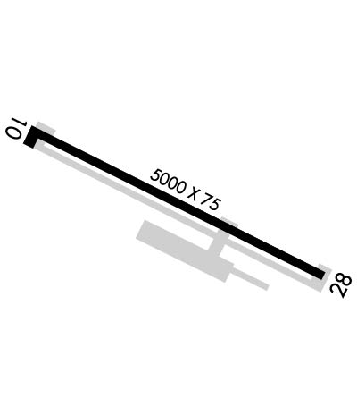 Airport Diagram might not be current. | |
| Facility Name: | MOUNTAIN HOME MUNI |
| City Name: | MOUNTAIN HOME |
| County: | ELMORE |
| State abbrev: | ID |
| State Name: | IDAHO |
| Ownership: | PUBLICLY OWNED |
| Use: | OPEN TO THE PUBLIC |
| Owner's Name: | CITY OF MOUNTAIN HOME |
| Address: | PO BOX 10 |
| MOUNTAIN HOME, ID 83647 | |
| Owner's Phone: | 208-587-2104 |
| Manager's Name: | THOMAS HOEGG; CLETIS HOLDEN: 208-254-1953 / INFO@CKAVIATIONSERVICES.COM |
| Address: | 2614 AIRBASE RD |
| MOUNTAIN HOME, ID 83647 | |
| Phone: | 208-599-0609; ALT CTC CELL 208-598-1653. |
| FAA Region: | NORTHWEST MOUNTAIN |
| FAA Field Office: | HLN |

| Date | Sunrise | Sunset |
|---|---|---|
| 04/17/24 Wednesday | 6:56 | 20:29 |
| 04/18/24 Thursday | 6:55 | 20:30 |
| 04/19/24 Friday | 6:53 | 20:31 |
| 04/20/24 Saturday | 6:52 | 20:32 |
| 04/21/24 Sunday | 6:50 | 20:34 |
| 04/22/24 Monday | 6:48 | 20:35 |
| 04/23/24 Tuesday | 6:47 | 20:36 |
| 04/24/24 Wednesday | 6:45 | 20:37 |
| 04/25/24 Thursday | 6:44 | 20:38 |
| 04/26/24 Friday | 6:42 | 20:39 |
| 04/27/24 Saturday | 6:41 | 20:41 |
| 04/28/24 Sunday | 6:39 | 20:42 |
| 04/29/24 Monday | 6:38 | 20:43 |
| 04/30/24 Tuesday | 6:37 | 20:44 |
| Airport Attendance Schedule | MON-FRI 0800-1700 |
| Airport Status | OPERATIONAL (This Status can change at any time - please check NOTAMS) |
| Airport Lighting Schedule | ACTVT REIL RWY 10 & 28; PAPI RWY 10 & 28; MIRL RWY 10/28 - CTAF. |
| Airport Storage Available | Tie Downs |
| Extra Services Available | Crop Dusting, Flight Instruction, Aircraft Rental |
| Wind Indicator | YES - (lighted) |
| Control Tower | NO |
| CTAF Frequency | 122.800 |
| Unicom Frequency | 122.800; AUTOMATED UNICOM. |
| Rotating Beacon Color | WG |
| Segmented Circle | YES |
| Landing Fee | NO |
| Airport Inspected | STATE - performed by STATE AERONAUTICAL PERSONNEL |
| Inspection Date | 04/22/2021 |
| Type of Fuel Available | Grade 100LL, JET A (freeze point -40C); -10 100LL AVBL 24 HRS WITH CREDIT CARD.; -A JET A AVBL 24 HRS WITH CREDIT CARD. JET A SINGLE POINT AVBL MON-FRI 1500-0100Z OR BY APPOINTMENT CALL (208) 587-3585. |
| Airframe Repair Service | MAJOR |
| Power Plant Repair Service | MAJOR |
| Latitude | N4307.9 |
| Longitude | W11543.8 (ESTIMATED) |
| Arpt Elevation | 3166ft (SURVEYED) |
| Magnetic Variation | 13E |
| 2 miles W | of MOUNTAIN HOME |
| Traffic Pattern Altitude | |
| Sectional Chart | SALT LAKE CITY |
| Operations (Reported) | Yearly | Avg. Daily |
|---|---|---|
| General Aviation Transient | 6000 | 16 |
| General Aviation Local | 10000 | 27 |
| Air Taxi | 0 | 0 |
| Commerical | 0 | 0 |
| Commuter | 0 | 0 |
| Military | 1500 | 4 |
| Aircraft based on Field | |
|---|---|
| General Aviation Singles | 17 |
| General Aviation Multi | 1 |
| Jet Aircraft | 0 |
| General Aviation Helicopters | 1 |
| Military Aircraft | 0 |
| Gliders | 0 |
| Ultralights | 0 |
| FSS on field | NO |
| FSS tie-in | BOISE |
| FSS Phone | 1-800-WX-BRIEF |
| Who issues Notams | BOI |
| Notam D service at airport | YES |
| ARTCC Name | SALT LAKE CITY |
| Airport Certification | |
| Aircraft Rescue & Firefighting Index | None |
| Airport of Entry | No |
| Custom Landing Rights | No |
| Joint Civil/Military | No |
| Military Landing rights | YES |
| NATIONAL PLAN OF INTEGRATED AIRPORT SYSTEMS (NPIAS) |
| GRANT AGREEMENTS UNDER FAAP/ADAP/AIP |
| ASSURANCES PURSUANT TO TITLE VI, CIVIL RIGHTS ACT OF 1964 |
| HIGH PERFORMANCE MIL JET OPNS CONDUCTED AT MOUNTAIN HOME AFB 8 NM SW OF ARPT. |
| EXTENSIVE AGRICULTURAL OPERATIONS. |
Airport Communications & Frequencies:
| |||||||||||||||||
| Runway: 10 | Runway: 28 | ||
| Mag heading: | 103° | Mag heading: | 283° |
| Rwy Slope: | -.18% Down | Rwy Slope: | .18% Up |
| Approach: | Approach: | ||
| Pattern: | Left Traffic | Pattern: | Left Traffic |
| Markings: | NONPRECISION INSTRUMENT | Markings: | NONPRECISION INSTRUMENT |
| Marking Condition: | GOOD | Marking Condition: | GOOD |
| Arresting Dev: | Arresting Dev: | ||
| Lat & Long: | N4308.1 W11544.3 | Lat. & Long.: | N4307.7 W11543.3 |
| Elev: | 3166.6 ft. MSL | Elev: | 3157.8 ft. MSL |
| TCH: | 43 ft. AGL | TCH: | 43 ft. AGL |
| Visual Glide Path: | 3.00 degrees | Visual Glide Path: | 3.00 degrees |
| Displaced Threshold: | No | Displaced Threshold: | No |
| Touchdown Zone: | YES | Touchdown Zone: | YES |
| Touchdown Elev.: | 3166.6 feet | Touchdown Elev.: | 3164.7 feet |
| Visual Glide Slope: | 2-Light PAPI on LEFT side of Runway | Visual Glide Slope: | 2-Light PAPI on LEFT side of Runway |
| RVR Equipment: | RVR Equipment: | ||
| RVV Equipment: | NO | RVV Equipment: | NO |
| Approach Lights: | Approach Lights: | ||
| REIL: | YES | REIL: | YES |
| Centerline Lights: | NO | Centerline Lights: | NO |
| Touchdown lights: | NO | Touchdown lights: | NO |
| Runway Category: | Runway with a Visual Approach | Runway Category: | Runway with a Non-precision Approach having visibility minimums greater than 3/4 mile |
| Declared Distances: | Declared Distances: | ||
| Obstructions: | Unknown | Obstructions: | PLINE |
| Marked: | NOT Marked/Lighted | Marked: | MARKED and LIGHTED |
| Clearance slope: | 20:1 | Clearance slope: | 24:1 |
| Obstruction height: | 0 feet AGL | Obstruction height: | 50 feet AGL |
| Dist. from runway: | 0 feet | Dist. from runway: | 1400 feet |
| Centerline offset: | Centerline offset: | ||
| Comments: | Comments: |
