Current Weather/Notams (Metars, TAFs, Notams, NWS Forecast, PIREPS, and nearby weather)
Customs Information Send updates to Support@FltPlan.com
Customs Not Available
Database effective 04/18/2024
Airport Diagram might not be current.
|
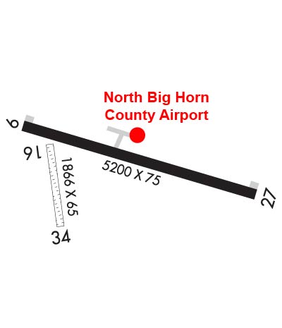
| Facility Name: | NORTH BIG HORN COUNTY |
| City Name: | COWLEY/LOVELL/BYRON |
| County: | BIG HORN |
| State abbrev: | WY |
| State Name: | WYOMING |
| | |
| Ownership: | PUBLICLY OWNED |
| Use: | OPEN TO THE PUBLIC |
| Owner's Name: | BIG HORN COUNTY |
| Address: | BOX 29 |
| | BASIN, WY 82410 |
| Owner's Phone: | 307-568-2551 |
| | |
| Manager's Name: | PAUL THUR |
| Address: | P. O. BOX 29, PO BOX 31 |
| | BASIN, WY 82410 |
| Phone: | 307-337-8159 |
| | |
| FAA Region: | NORTHWEST MOUNTAIN |
| FAA Field Office: | DEN |
Runway Identifications
Runway Identification: 09/27Length: 5200 ft
Width: 75 ft
Surface: ASPHALT-GOOD CONDITION
Edge lights: Medium IntensityTreatment: NONE
| | Runway: 09 | | Runway: 27 |
| Mag heading: | 95° | Mag heading: | 275° |
| Rwy Slope: | .19% Up | Rwy Slope: | -.19% Down |
| Approach: | | Approach: | |
| Pattern: | Left Traffic | Pattern: | Left Traffic |
| Markings: | NONPRECISION INSTRUMENT | Markings: | NONPRECISION INSTRUMENT |
| Marking Condition: | GOOD | Marking Condition: | GOOD |
| Arresting Dev: | | Arresting Dev: | |
| Lat & Long: | N4454.8 W10827.2 | Lat. & Long.: | N4454.6 W10826.0 |
| Elev: | 4083.4 ft. MSL | Elev: | 4093.5 ft. MSL |
| TCH: | 40 ft. AGL | TCH: | 40 ft. AGL |
| Visual Glide Path: | 3.00 degrees | Visual Glide Path: | 3.00 degrees |
| Displaced Threshold: | No | Displaced Threshold: | No |
| Touchdown Zone: | YES | Touchdown Zone: | YES |
| Touchdown Elev.: | 4086.1 feet | Touchdown Elev.: | 4093.5 feet |
| Visual Glide Slope: | 2-Light PAPI on LEFT side of Runway | Visual Glide Slope: | 2-Light PAPI on LEFT side of Runway |
| RVR Equipment: | | RVR Equipment: | |
| RVV Equipment: | NO | RVV Equipment: | NO |
| Approach Lights: | | Approach Lights: | |
| REIL: | YES | REIL: | YES |
| Centerline Lights: | NO | Centerline Lights: | NO |
| Touchdown lights: | NO | Touchdown lights: | NO |
| Runway Category: | Runway with a Non-precision Approach | Runway Category: | Runway with a Visual Approach |
| Declared Distances: | | Declared Distances: | |
| Obstructions: | HILL | Obstructions: | HILL |
| Marked: | NOT Marked/Lighted | Marked: | NOT Marked/Lighted |
| Clearance slope: | 14:1 | Clearance slope: | 38:1 |
| Obstruction height: | 8 feet AGL | Obstruction height: | 91 feet AGL |
| Dist. from runway: | 315 feet | Dist. from runway: | 3673 feet |
| Centerline offset: | 90 right of centerline | Centerline offset: | 40 feet left of centerline |
| Comments: | | Comments: | |
Runway Identification: 16/34Length: 1866 ft
Width: 65 ft
Surface: NATURAL SOIL-GOOD CONDITION
Edge lights: Treatment: NONE
| | Runway: 16 | | Runway: 34 |
| Mag heading: | 161° | Mag heading: | 341° |
| Rwy Slope: | .12% Up | Rwy Slope: | -.12% Down |
| Approach: | | Approach: | |
| Pattern: | Left Traffic | Pattern: | Left Traffic |
| Markings: | NONE | Markings: | NONE |
| Marking Condition: | GOOD; 16/34 RWY END DELINATED BY +1 FT CONES. | Marking Condition: | GOOD |
| Arresting Dev: | | Arresting Dev: | |
| Lat & Long: | N4454.8 W10827.0 | Lat. & Long.: | N4454.5 W10827.0 |
| Elev: | 4080.9 ft. MSL | Elev: | 4083.2 ft. MSL |
| TCH: | | TCH: | |
| Visual Glide Path: | | Visual Glide Path: | |
| Displaced Threshold: | No | Displaced Threshold: | No |
| Touchdown Zone: | YES | Touchdown Zone: | YES |
| Touchdown Elev.: | 4083.2 feet | Touchdown Elev.: | 4083.2 feet |
| Visual Glide Slope: | | Visual Glide Slope: | |
| RVR Equipment: | | RVR Equipment: | |
| RVV Equipment: | NO | RVV Equipment: | NO |
| Approach Lights: | | Approach Lights: | |
| REIL: | NO | REIL: | NO |
| Centerline Lights: | NO | Centerline Lights: | NO |
| Touchdown lights: | NO | Touchdown lights: | NO |
| Runway Category: | Runway with a Visual Approach | Runway Category: | Runway with a Visual Approach |
| Declared Distances: | | Declared Distances: | |