Approach Charts
| FltPlan does not have IFR approach charts available for KU58. |
Current Weather/Notams (Metars, TAFs, Notams, NWS Forecast, PIREPS, and nearby weather)
Customs Information Send updates to Support@FltPlan.com
Customs Not Available
Database effective 05/16/2024
Airport Diagram might not be current.
|
| Facility Name: | DOWNEY/HYDE MEML/ |
| City Name: | DOWNEY |
| County: | BANNOCK |
| State abbrev: | ID |
| State Name: | IDAHO |
| | |
| Ownership: | PUBLICLY OWNED |
| Use: | OPEN TO THE PUBLIC |
| Owner's Name: | CITY OF DOWNEY |
| Address: | PO BOX 204 |
| | DOWNEY, ID 83234 |
| Owner's Phone: | 208-897-5342 |
| | |
| Manager's Name: | JOHN HYDE |
| Address: | CITY OF DOWNEY, 15 S. MAIN ST. |
| | DOWNEY, ID 83234 |
| Phone: | 208-851-0348 |
| | |
| FAA Region: | NORTHWEST MOUNTAIN |
| FAA Field Office: | HLN |
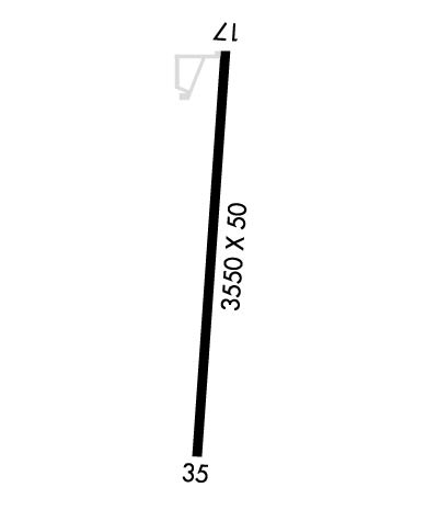
Runway Identifications
Runway Identification: 17/35Length: 3550 ft
Width: 50 ft
Surface: ASPHALT-FAIR CONDITION
Edge lights: Low IntensityTreatment: NONE
| | Runway: 17 | | Runway: 35 |
| Mag heading: | N/A | Mag heading: | N/A |
| Rwy Slope: | .42% Up | Rwy Slope: | -.42% Down |
| Approach: | | Approach: | |
| Pattern: | Left Traffic | Pattern: | Left Traffic |
| Markings: | NUMBERS ONLY | Markings: | NUMBERS ONLY |
| Marking Condition: | FAIR | Marking Condition: | FAIR |
| Arresting Dev: | | Arresting Dev: | |
| Lat & Long: | N4225.7 W11206.5 | Lat. & Long.: | N4225.2 W11206.6 |
| Elev: | 4904.0 ft. MSL | Elev: | 4919.0 ft. MSL |
| TCH: | | TCH: | |
| Visual Glide Path: | | Visual Glide Path: | |
| Displaced Threshold: | No | Displaced Threshold: | No |
| Touchdown Zone: | NO | Touchdown Zone: | NO |
| Touchdown Elev.: | | Touchdown Elev.: | |
| Visual Glide Slope: | | Visual Glide Slope: | |
| RVR Equipment: | | RVR Equipment: | |
| RVV Equipment: | NO | RVV Equipment: | NO |
| Approach Lights: | | Approach Lights: | |
| REIL: | NO | REIL: | NO |
| Centerline Lights: | NO | Centerline Lights: | NO |
| Touchdown lights: | NO | Touchdown lights: | NO |
| Runway Category: | Runway with a Visual Approach | Runway Category: | Runway with a Visual Approach |
| Declared Distances: | | Declared Distances: | |
| Obstructions: | TANK | Obstructions: | ROAD |
| Marked: | NOT Marked/Lighted | Marked: | NOT Marked/Lighted |
| Clearance slope: | 10:1 | Clearance slope: | |
| Obstruction height: | 25 feet AGL | Obstruction height: | 15 feet AGL |
| Dist. from runway: | 450 feet | Dist. from runway: | 200 feet |
| Centerline offset: | 150 right of centerline | Centerline offset: | 115 feet left of centerline |
| Comments: | RWY 17 +3 FT FENCE 15 FT FM RY END & +3 FT FENCE 45 FT FM RY END; +7 FT PVT ROAD 30 FT FM RY END; +10 BLDG 75 FT R 100 FT FM RY END. | Comments: | RY 35 +15 FT ROAD 0 FT FROM RY END 120 FT L; +2 FT FENCE AT 15 FT ON CNTRLN. |

