Click here for more info on on SMS!

KU36

ABERDEEN MUNI
ABERDEEN
ID
Time Zone: Mountain
Lat: N 4255.3
Long: W 11252.9
Elev: 4474
Var: -16
Longest Runway: 3690
CTAF: 122.9

FBO & Flight Services info for KU36

FBOs: Update your Fuel Prices

ABERDEEN MUNIPh: 208-397-4758
-
Freq: 122.9
Service
Jet
100LL
SAF
MoGas
Fuel Avail: NO FUEL AVAILABLE
Full        Last Update: 04/15/2024 06:01:01

Self        
If you are an FBO, call 1-203-262-1700 to update your info or email: FltPlan.Advertising@garmin.com
Advertise your FBO on FltPlan.com

Runway & Approach Info for KU36
Rwy
Length
Land Dist**
Approach*
  Rwy
Length
Land Dist**
Approach*
07
3690x50  3548'          
 
  
25
  3690x50  3178'          
 
 * only ILS, LOC, LDA, and SDF approaches to a specific runway are shown
** For any Declared Landing Distance Available, please see A/FD or Approach plates
Runway Weight Capability (lbs.) Help
Runway IDSingle WheelDouble WheelDouble Tandem WheelDual Double Wheel
07/25N/AN/AN/AN/A
These numbers are Advisory and are not limits.   The Airport Manager should have more accurate Weight Limits
Approach Charts
FltPlan does not have IFR approach charts available for KU36.
Current Weather/Notams
Customs Information Send updates to Support@FltPlan.com
Customs Not Available
Database effective 04/18/2024
Airport Diagram of KU36
Airport Diagram might not be current.

Facility Name: ABERDEEN MUNI
City Name: ABERDEEN
County: BINGHAM
State abbrev: ID
State Name: IDAHO
   
Ownership: PUBLICLY OWNED
Use: OPEN TO THE PUBLIC
Owner's Name: CITY OF ABERDEEN
Address: P O BOX 190
 ABERDEEN, ID 83210
Owner's Phone: 208-397-4161
  
Manager's Name: ROBERT GOSS
Address: P.O. BOX 190
 ABERDEEN, ID 83210
Phone: 208-244-1885
   
FAA Region: NORTHWEST MOUNTAIN
FAA Field Office: HLN


Sunrise / Sunset times for ABERDEEN MUNI

DateSunriseSunset
04/15/24 Monday6:4820:15
04/16/24 Tuesday6:4720:16
04/17/24 Wednesday6:4520:17
04/18/24 Thursday6:4420:18
04/19/24 Friday6:4220:20
04/20/24 Saturday6:4020:21
04/21/24 Sunday6:3920:22
04/22/24 Monday6:3720:23
04/23/24 Tuesday6:3620:24
04/24/24 Wednesday6:3420:25
04/25/24 Thursday6:3320:26
04/26/24 Friday6:3120:28
04/27/24 Saturday6:3020:29
04/28/24 Sunday6:2920:30

Airport Facilities

Airport Attendance ScheduleJAN-DEC MON-SUN DALGT
Airport Status OPERATIONAL (This Status can change at any time - please check NOTAMS)
Airport Lighting ScheduleACTVT MIRL RY 07/25 - CTAF.
Airport Storage AvailableTie Downs
Extra Services AvailableCrop Dusting
Wind IndicatorYES - (lighted)
Control TowerNO
CTAF Frequency122.900
Unicom Frequency
Rotating Beacon ColorWG
Segmented CircleYES
Landing FeeNO

Airport Inspection Data

Airport InspectedSTATE - performed by STATE AERONAUTICAL PERSONNEL
Inspection Date06/09/2021

Airport Services

Type of Fuel AvailableNone
Airframe Repair ServiceNone
Power Plant Repair ServiceNone

Geographic Data

LatitudeN4255.3
LongitudeW11252.9 (ESTIMATED)
Arpt Elevation4473ft (ESTIMATED)
Magnetic Variation16E
2 miles SWof ABERDEEN
Traffic Pattern Altitude
Sectional ChartSALT LAKE CITY

Aircraft Data

Operations (Reported)YearlyAvg. Daily
General Aviation Transient 450012
General Aviation Local 30008
Air Taxi 00
Commerical 00
Commuter 00
Military 00
Aircraft based on Field
General Aviation Singles 18
General Aviation Multi 1
Jet Aircraft 0
General Aviation Helicopters 0
Military Aircraft 0
Gliders 0
Ultralights 0

FAA Services

FSS on field NO
FSS tie-in BOISE
FSS Phone 1-800-WX-BRIEF
Who issues Notams BOI
Notam D service at airport YES
ARTCC Name SALT LAKE CITY

Federal Status

Airport Certification
Aircraft Rescue & Firefighting IndexNone
Airport of EntryNo
Custom Landing RightsNo
Joint Civil/MilitaryNo
Military Landing rightsNo

Federal Agreements

NATIONAL PLAN OF INTEGRATED AIRPORT SYSTEMS (NPIAS)

Remarks

IREG WINTER MAINTENANCE.
CONSIDERABLE AGRICULTURE OPS DURING GROWING SEASON.
+30 FT SPRINKLER AND TERRAIN AT 230 FT FM SW END OF RY MAY BE IN POSITION.
FOR CD CTC SALT LAKE ARTCC AT 801-320-2568.
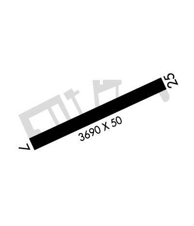
Runway Identifications
Runway Identification: 07/25
Length: 3690 ft
Width: 50 ft
Surface: ASPHALT-FAIR CONDITION
Edge lights: Medium Intensity

Treatment: NONE

 Runway: 07   Runway: 25
Mag heading: N/AMag heading: N/A
Rwy Slope: -.82% DownRwy Slope: .82% Up
Approach: Approach:
Pattern: Left TrafficPattern: Left Traffic
Markings: BASICMarkings: BASIC
Marking Condition: FAIRMarking Condition: FAIR
Arresting Dev: Arresting Dev:
Lat & Long: N4255.2  W11253.3Lat. & Long.: N4255.3  W11252.4
Elev: 4473.5 ft. MSLElev: 4443.4 ft. MSL
TCH: TCH:
Visual Glide Path: Visual Glide Path:
Displaced Threshold: 142 feetDisplaced Threshold: 512 feet
Touchdown Zone: NOTouchdown Zone: NO
Touchdown Elev.: Touchdown Elev.:
Visual Glide Slope: Visual Glide Slope:
RVR Equipment: RVR Equipment:
RVV Equipment: NORVV Equipment: NO
Approach Lights: Approach Lights:
REIL: NOREIL: NO
Centerline Lights: NOCenterline Lights: NO
Touchdown lights: NOTouchdown lights: NO
Runway Category: Runway with a Visual ApproachRunway Category: Runway with a Visual Approach
Declared Distances: TORA:3690' TODA:3690' ASDA:3466' LDA:3324'Declared Distances: TORA:3458' TODA:3458' ASDA:3624' LDA:3112'
Obstructions: ROAD; +70 FT PLINE & TERRAIN AT 3000 FT ON CNTRLN.Obstructions: FENCE; +50 FT TREE AT 400 FT; 125 FT LEFT.
Marked: NOT Marked/LightedMarked: NOT Marked/Lighted
Clearance slope: Clearance slope:
Obstruction height: 15 feet AGLObstruction height: 2 feet AGL
Dist. from runway: 210 feetDist. from runway: 200 feet
Centerline offset: Centerline offset:
Comments: +4' FENCE AT 0', 100' RIGHT.Comments: +3 FT FENCE AT 0 FT, 90 FT R. +18 FT ROAD AT 0 FT 100 FT R.
C:/P: