Click here for more info on on SMS!

KU01

AMERICAN FALLS
AMERICAN FALLS
ID
Time Zone: Mountain
Lat: N 4247.8
Long: W 11249.5
Elev: 4419
Var: -16
Longest Runway: 4900
CTAF: 122.8

FBO & Flight Services info for KU01

FBOs: Update your Fuel Prices

AMERICAN AIRPh: 208-226-2666 Fax: 208-226-5451 Freq: 122.8
Service
Jet
100LL
SAF
MoGas
Fuel Avail: NO FUEL AVAILABLE
Full        Last Update: 04/23/2024 05:40:08

Self        
If you are an FBO, call 1-203-262-1700 to update your info or email: FltPlan.Advertising@garmin.com
Advertise your FBO on FltPlan.com

Runway & Approach Info for KU01
Rwy
Length
Land Dist**
Approach*
  Rwy
Length
Land Dist**
Approach*
03
4900x50  4900'          
 
  
21
  4900x50  4900'          
 
 * only ILS, LOC, LDA, and SDF approaches to a specific runway are shown
** For any Declared Landing Distance Available, please see A/FD or Approach plates
Runway Weight Capability (lbs.) Help
Runway IDSingle WheelDouble WheelDouble Tandem WheelDual Double Wheel
03/21N/AN/AN/AN/A
These numbers are Advisory and are not limits.   The Airport Manager should have more accurate Weight Limits
Approach Charts
FltPlan does not have IFR approach charts available for KU01.
Current Weather/Notams
Customs Information Send updates to Support@FltPlan.com
Customs Not Available
Database effective 05/16/2024
Airport Diagram of KU01
Airport Diagram might not be current.

Facility Name: AMERICAN FALLS
City Name: AMERICAN FALLS
County: POWER
State abbrev: ID
State Name: IDAHO
   
Ownership: PUBLICLY OWNED
Use: OPEN TO THE PUBLIC
Owner's Name: POWER COUNTY
Address: 543 BANNOCK AVENUE
 AMERICAN FALLS, ID 83211
Owner's Phone: 208-226-7611
  
Manager's Name: DALLEN WARD
Address: 5203 MOHAWK
 POCATELLO, ID 83204-5401
Phone: 208-223-6276
   
FAA Region: NORTHWEST MOUNTAIN
FAA Field Office: HLN
Photo courtesy of John Jackson and Tom Walters


Click here for full scale & interactive Sectional view of KU01


Sunrise / Sunset times for AMERICAN FALLS

DateSunriseSunset
04/22/24 Monday6:3720:23
04/23/24 Tuesday6:3620:24
04/24/24 Wednesday6:3420:25
04/25/24 Thursday6:3320:26
04/26/24 Friday6:3120:27
04/27/24 Saturday6:3020:28
04/28/24 Sunday6:2920:29
04/29/24 Monday6:2720:31
04/30/24 Tuesday6:2620:32
05/01/24 Wednesday6:2420:33
05/02/24 Thursday6:2320:34
05/03/24 Friday6:2220:35
05/04/24 Saturday6:2020:36
05/05/24 Sunday6:1920:37

Airport Facilities

Airport Attendance Schedule7 Days A Week 0800-1800
Airport Status OPERATIONAL (This Status can change at any time - please check NOTAMS)
Airport Lighting ScheduleACTVT TRCV RWY 21; MIRL RWY 03/21 - CTAF (5 CLICKS).
Airport Storage AvailableTie Downs
Extra Services AvailableFlight Instruction
Wind IndicatorYES - (lighted)
Control TowerNO
CTAF Frequency122.800
Unicom Frequency122.800
Rotating Beacon ColorWG
Segmented CircleNO
Landing FeeNO

Airport Inspection Data

Airport InspectedSTATE - performed by STATE AERONAUTICAL PERSONNEL
Inspection Date05/16/2022

Airport Services

Type of Fuel AvailableGrade 100LL
Airframe Repair ServiceNONE
Power Plant Repair ServiceNONE

Geographic Data

LatitudeN4247.8
LongitudeW11249.5 (ESTIMATED)
Arpt Elevation4419ft (ESTIMATED)
Magnetic Variation16E
2 miles NEof AMERICAN FALLS
Traffic Pattern Altitude
Sectional ChartSALT LAKE CITY

Aircraft Data

Operations (Reported)YearlyAvg. Daily
General Aviation Transient 1300036
General Aviation Local 500014
Air Taxi 00
Commerical 00
Commuter 00
Military 250
Aircraft based on Field
General Aviation Singles 32
General Aviation Multi 1
Jet Aircraft 0
General Aviation Helicopters 3
Military Aircraft 0
Gliders 0
Ultralights 0

FAA Services

FSS on field NO
FSS tie-in BOISE
FSS Phone 1-800-WX-BRIEF
Who issues Notams BOI
Notam D service at airport YES
ARTCC Name SALT LAKE CITY

Federal Status

Airport Certification
Aircraft Rescue & Firefighting IndexNone
Airport of EntryNo
Custom Landing RightsNo
Joint Civil/MilitaryNo
Military Landing rightsNo

Remarks

FREQUENT HELICOPTER OPS YEAR AROUND.
IRREGULAR SNOW REMOVAL.
NO LINE OF SITE BETWEEN RUNWAY ENDS.
FOR CD CTC SALT LAKE ARTCC AT 801-320-2568.
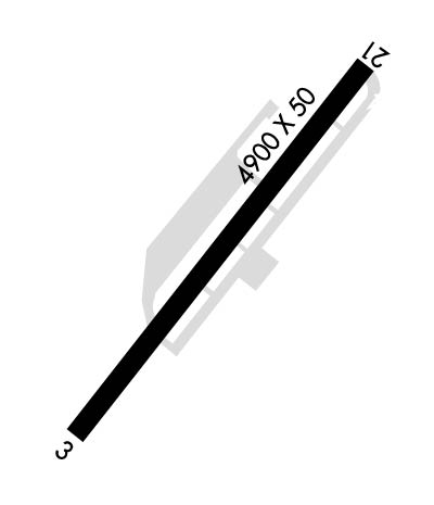
Runway Identifications
Runway Identification: 03/21
Length: 4900 ft
Width: 50 ft
Surface: ASPHALT-GOOD CONDITION
Edge lights: Medium Intensity

Treatment: NONE

 Runway: 03   Runway: 21
Mag heading: 36°Mag heading: 216°
Rwy Slope: .01% UpRwy Slope: -.01% Down
Approach: Approach:
Pattern: Left TrafficPattern: Left Traffic
Markings: BASICMarkings: BASIC
Marking Condition: FAIRMarking Condition: FAIR
Arresting Dev: Arresting Dev:
Lat & Long: N4247.6  W11249.9Lat. & Long.: N4248.1  W11249.1
Elev: 4412.7 ft. MSLElev: 4413.2 ft. MSL
TCH: TCH: 50 ft. AGL
Visual Glide Path: Visual Glide Path: 3.50 degrees
Displaced Threshold: NoDisplaced Threshold: No
Touchdown Zone: YESTouchdown Zone: YES
Touchdown Elev.: 4419.0 feetTouchdown Elev.: 4419.0 feet
Visual Glide Slope: Visual Glide Slope: TRI-COLOR VASI ON LEFT SIDE OF RUNWAY
RVR Equipment: RVR Equipment:
RVV Equipment: NORVV Equipment: NO
Approach Lights: Approach Lights:
REIL: NOREIL: NO
Centerline Lights: NOCenterline Lights: NO
Touchdown lights: NOTouchdown lights: NO
Runway Category: Runway with a Visual ApproachRunway Category: Runway with a Visual Approach
Declared Distances: Declared Distances:
Obstructions: FENCEObstructions: HILL
Marked: NOT Marked/LightedMarked: NOT Marked/Lighted
Clearance slope: Clearance slope: 20:1
Obstruction height: 4 feet AGLObstruction height: 24 feet AGL
Dist. from runway: 200 feetDist. from runway: 700 feet
Centerline offset: 30 right of centerlineCenterline offset:
Comments: HAS A 4 FT HIGH FENCE 0 FT FROM THLD AND 30 FT R.Comments:
C:/P: