Click here for more info on on SMS!

KTZV

TOMPKINSVILLE-MONROE COUNTY
TOMPKINSVILLE
KY
Time Zone: Central
Lat: N 3643.7
Long: W 08539.1
Elev: 1036
Var: +04
Longest Runway: 4000
AWOS: 123.05
CTAF: 123.05

FBO & Flight Services info for KTZV

FBOs: Update your Fuel Prices

TOMPKINSVILLEPh: 270-487-0678
-
Freq: 122.8
Service
Jet
100LL
SAF
MoGas
Full        Last Update: 04/12/2024 15:22

Self  5.40    
 Address: 661 LYONS CHAPEL RD   TOMPKINSVILLE, KY42167
AWOS
-
Freq: 123.05  
If you are an FBO, call 1-203-262-1700 to update your info or email: FltPlan.Advertising@garmin.com
Advertise your FBO on FltPlan.com

Runway & Approach Info for KTZV
Rwy
Length
Land Dist**
Approach*
  Rwy
Length
Land Dist**
Approach*
04
4000x75  4000'          
 
  
22
  4000x75  4000'          
 
 * only ILS, LOC, LDA, and SDF approaches to a specific runway are shown
** For any Declared Landing Distance Available, please see A/FD or Approach plates
Runway Weight Capability (lbs.) Help
Runway IDSingle WheelDouble WheelDouble Tandem WheelDual Double Wheel
04/2212,000N/AN/AN/A
These numbers are Advisory and are not limits.   The Airport Manager should have more accurate Weight Limits
Approach Charts
Approaches    
Current Weather/Notams
Customs Information Send updates to Support@FltPlan.com
Customs Not Available
Database effective 05/16/2024
Airport Diagram of KTZV
Airport Diagram might not be current.

Facility Name: TOMPKINSVILLE/MONROE COUNTY
City Name: TOMPKINSVILLE
County: MONROE
State abbrev: KY
State Name: KENTUCKY
   
Ownership: PUBLICLY OWNED
Use: OPEN TO THE PUBLIC
Owner's Name: TOMPKINSVILLE-MONROE CO APT
Address: P.O. BOX 175
 TOMPKINSVILLE, KY 42167
Owner's Phone: 270-487-0678
  
Manager's Name: KANEIA COPASS
Address: PO BOX 175
 TOMPKINSVILLE, KY 42167
Phone: 270-646-0544; 214-458-0600
   
FAA Region: SOUTHERN
FAA Field Office: MEM


Sunrise / Sunset times for TOMPKINSVILLE/MONROE COUNTY

DateSunriseSunset
04/23/24 Tuesday5:5719:25
04/24/24 Wednesday5:5619:26
04/25/24 Thursday5:5519:27
04/26/24 Friday5:5419:27
04/27/24 Saturday5:5219:28
04/28/24 Sunday5:5119:29
04/29/24 Monday5:5019:30
04/30/24 Tuesday5:4919:31
05/01/24 Wednesday5:4819:32
05/02/24 Thursday5:4719:33
05/03/24 Friday5:4619:34
05/04/24 Saturday5:4519:34
05/05/24 Sunday5:4419:35
05/06/24 Monday5:4319:36

Airport Facilities

Airport Attendance ScheduleUNATTENDED
Airport Status OPERATIONAL (This Status can change at any time - please check NOTAMS)
Airport Lighting ScheduleACTVT REIL RWY 04 & 22; PAPI RWY 04 & 22; MIRL RWY 04/22 - CTAF.
Airport Storage AvailableTie Downs, Hanger
Extra Services AvailableNONE
Wind IndicatorYES - (lighted)
Control TowerNO
CTAF Frequency123.050
Unicom Frequency123.050
Rotating Beacon ColorWG
Segmented CircleNO
Landing FeeNO

Airport Inspection Data

Airport InspectedSTATE - performed by STATE AERONAUTICAL PERSONNEL
Inspection Date04/07/2021

Airport Services

Type of Fuel AvailableGrade 100LL
Airframe Repair ServiceMAJOR
Power Plant Repair ServiceMAJOR

Geographic Data

LatitudeN3643.7
LongitudeW08539.1 (ESTIMATED)
Arpt Elevation1036ft (SURVEYED)
Magnetic Variation04W
2 miles NEof TOMPKINSVILLE
Traffic Pattern Altitude
Sectional ChartST LOUIS

Aircraft Data

Operations (Reported)YearlyAvg. Daily
General Aviation Transient 16004
General Aviation Local 872024
Air Taxi 8402
Commerical 00
Commuter 00
Military 3001
Aircraft based on Field
General Aviation Singles 40
General Aviation Multi 10
Jet Aircraft 0
General Aviation Helicopters 0
Military Aircraft 0
Gliders 0
Ultralights 0

FAA Services

FSS on field NO
FSS tie-in LOUISVILLE
FSS Phone 1-800-WX-BRIEF
Who issues Notams LOU
Notam D service at airport YES
ARTCC Name MEMPHIS

Federal Status

Airport Certification
Aircraft Rescue & Firefighting IndexNone
Airport of EntryNo
Custom Landing RightsNo
Joint Civil/MilitaryNo
Military Landing rightsNo

Remarks

USE CTAF FOR TRML ACES.
FOR CD CTC MEMPHIS ARTCC AT 901-368-8453/8449.
Airport Communications & Frequencies:
CTAF Frequency:
123.050
Unicom Frequency:
123.050
Remarks
  • APCH/DEP SVC PRVDD BY MEMPHIS ARTCC ON FREQS 132.9/290.3 (NASHVILLE/JOELTON RCAG).
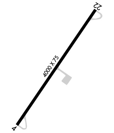
  • Runway Identifications
    Runway Identification: 04/22
    Length: 4000 ft
    Width: 75 ft
    Surface: ASPHALT-GOOD CONDITION
    Edge lights: Medium Intensity

    Treatment: NONE

     Runway: 04   Runway: 22
    Mag heading: 38°Mag heading: 218°
    Rwy Slope: .52% UpRwy Slope: -.52% Down
    Approach: Approach:
    Pattern: Left TrafficPattern: Left Traffic
    Markings: NONPRECISION INSTRUMENTMarkings: NONPRECISION INSTRUMENT
    Marking Condition: FAIR; ALGAE COVERED.Marking Condition: FAIR; ALGAE COVERED.
    Arresting Dev: Arresting Dev:
    Lat & Long: N3643.5  W08539.4Lat. & Long.: N3644.0  W08538.9
    Elev: 1015.3 ft. MSLElev: 1036.2 ft. MSL
    TCH: 41 ft. AGLTCH: 30 ft. AGL
    Visual Glide Path: 3.75 degreesVisual Glide Path: 3.00 degrees
    Displaced Threshold: NoDisplaced Threshold: No
    Touchdown Zone: YESTouchdown Zone: YES
    Touchdown Elev.: 1033.7 feetTouchdown Elev.: 1036.2 feet
    Visual Glide Slope: 2-Light PAPI on LEFT side of RunwayVisual Glide Slope: 2-Light PAPI on LEFT side of Runway
    RVR Equipment: RVR Equipment:
    RVV Equipment: NORVV Equipment: NO
    Approach Lights: Approach Lights:
    REIL: YESREIL: YES
    Centerline Lights: NOCenterline Lights: NO
    Touchdown lights: NOTouchdown lights: NO
    Runway Category: Runway with a Non-precision ApproachRunway Category: Runway with a Non-precision Approach
    Declared Distances: Declared Distances:
    Obstructions: TREESObstructions: TREES
    Marked: NOT Marked/LightedMarked: NOT Marked/Lighted
    Clearance slope: 17:1Clearance slope: 12:1
    Obstruction height: 116 feet AGLObstruction height: 41 feet AGL
    Dist. from runway: 2200 feetDist. from runway: 692 feet
    Centerline offset: 558 left of centerlineCenterline offset: 274 feet left of centerline
    Comments: Comments:
    C:2/P: