Click here for more info on on SMS!

KTYS

MC GHEE TYSON
KNOXVILLE
TN
Time Zone: Eastern
Lat: N 3548.7
Long: W 08359.6
Elev: 986
Var: +06
Longest Runway: 10000
Clr Del: 121.65
Dept. ATIS: 128.35
Arr. ATIS: 128.35
Ground: 121.9
Tower: 121.2

FBO & Flight Services info for KTYS

FBOs: Update your Fuel Prices
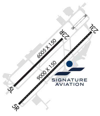
Land at any FBO in our growing worldwide network and you'll receive a warm, friendly Signature greeting. Consistent, exceptional service. Line support that's expert, safe and ready on the ramp. Clean, comfortable, well-furnished facilities. Service professionals who go the extra mile for your passengers and crew. Competitive pricing in every market.
Ph: 865-970-9000 Fax: 865-970-2604 Freq: 122.95WebsiteE-Mail
                          
Service
Jet
100LL
SAF
MoGas
Full7.057.94    Last Update: 04/18/2024 12:04

Self        
Misc. Info: JET-A + FSII ADDED FS $8.09. No Wingpoints at this locationAddress: 2343 W GENERAL AVIATION DRIVE SUITE A   ALCOA, TN 37701

ASOSPh: 865-981-4053
-
-
 
If you are an FBO, call 1-203-262-1700 to update your info or email: FltPlan.Advertising@garmin.com
Advertise your FBO on FltPlan.com

Runway & Approach Info for KTYS
Rwy
Length
Land Dist**
Approach*
  Rwy
Length
Land Dist**
Approach*
05L
10000x150  9510'          
ILS
 110.30 - 050°  
  
23R
  10000x150  9495'          
ILS
 111.70 - 230°  
05R
9000x150  9000'          
 
  
23L
  9000x150  8603'          
ILS/DME
 110.75 - 230°  
 * only ILS, LOC, LDA, and SDF approaches to a specific runway are shown
** For any Declared Landing Distance Available, please see A/FD or Approach plates
Runway Weight Capability (lbs.) Help
Runway IDSingle WheelDouble WheelDouble Tandem WheelDual Double Wheel
05L/23R120,000250,000550,0001,120,000
05R/23L75,000250,000489,0001,106,000
These numbers are Advisory and are not limits.   The Airport Manager should have more accurate Weight Limits
Approach Charts
Approaches    
Current Weather/Notams
Customs Information Send updates to Support@FltPlan.com
Phone 865-545-4771
Fax 865-545-4774

Comments 2 hrs advance notice required. Business hrs 0800-1700 Monday-Friday. *Call prior to 1430 on preceding weekday.
Database effective 04/18/2024
Airport Diagram of KTYS
Airport Diagram might not be current.

Facility Name: MC GHEE TYSON
City Name: KNOXVILLE
County: BLOUNT
State abbrev: TN
State Name: TENNESSEE
   
Ownership: PUBLICLY OWNED
Use: OPEN TO THE PUBLIC
Owner's Name: METRO KNOXVILLE ARPT AUTH
Address: MC GHEE TYSON AIRPORT, 2055 ALCOA HWY
 ALCOA, TN 37701
Owner's Phone: 865-342-3000
  
Manager's Name: PATRICK WILSON
Address: P.O. BOX 15600
 KNOXVILLE, TN 37901
Phone: 865-342-3088
   
FAA Region: SOUTHERN
FAA Field Office: MEM


Sunrise / Sunset times for MC GHEE TYSON

DateSunriseSunset
04/18/24 Thursday6:5820:13
04/19/24 Friday6:5720:13
04/20/24 Saturday6:5620:14
04/21/24 Sunday6:5420:15
04/22/24 Monday6:5320:16
04/23/24 Tuesday6:5220:17
04/24/24 Wednesday6:5120:18
04/25/24 Thursday6:5020:18
04/26/24 Friday6:4920:19
04/27/24 Saturday6:4720:20
04/28/24 Sunday6:4620:21
04/29/24 Monday6:4520:22
04/30/24 Tuesday6:4420:23
05/01/24 Wednesday6:4320:24

Airport Facilities

Airport Attendance ScheduleCONTINUOUS
Airport Status OPERATIONAL (This Status can change at any time - please check NOTAMS)
Airport Lighting ScheduleSS-SR
Airport Storage AvailableTie Downs, Hanger
Extra Services AvailableAir Freight, Avionics, Cargo Handling, Charter, Flight Instruction, Aircraft Rental, Aircraft Sales, Annual Surveying
Wind IndicatorYES - (lighted)
Control TowerYES
CTAF Frequency
Unicom Frequency122.950
Rotating Beacon ColorWG
Segmented CircleYES
Landing FeeNO

Airport Inspection Data

Airport InspectedFEDERAL - performed by FAA AIRPORTS FIELD PERSONNEL
Inspection Date05/23/2023

Airport Services

Type of Fuel AvailableGrade 100LL, JET A (freeze point -40C)A++; -10MIL CONTR FUEL VBL.
Airframe Repair ServiceMAJOR
Power Plant Repair ServiceMAJOR

Geographic Data

LatitudeN3548.7
LongitudeW08359.6 (ESTIMATED)
Arpt Elevation986ft (SURVEYED)
Magnetic Variation06W
10 miles Sof KNOXVILLE
Traffic Pattern Altitude
Sectional ChartATLANTA

Aircraft Data

Operations (Reported)YearlyAvg. Daily
General Aviation Transient 48448133
General Aviation Local 1794549
Air Taxi 1752848
Commerical 2713874
Commuter 00
Military 1364337
Aircraft based on Field
General Aviation Singles 84
General Aviation Multi 26
Jet Aircraft 50
General Aviation Helicopters 4
Military Aircraft 22
Gliders 0
Ultralights 0

FAA Services

FSS on field NO
FSS tie-in NASHVILLE
FSS Phone 1-800-WX-BRIEF
Who issues Notams TYS
Notam D service at airport YES
ARTCC Name ATLANTA

Federal Status

Airport CertificationAIRPORT RECEIVING SCHEDULED AIR CARRIER SERVICE FROM CARRIERS CERTIFICATED BY THE CIVIL AERONAUTICS BOARD
Aircraft Rescue & Firefighting IndexAIRPORT HAS A CERTIFICATE UNDER CFR PART 139
Airport of EntryNo
Custom Landing RightsYES
Joint Civil/MilitaryNo
Military Landing rightsYES

Federal Agreements

NATIONAL PLAN OF INTEGRATED AIRPORT SYSTEMS (NPIAS)
GRANT AGREEMENTS UNDER FAAP/ADAP/AIP
SURPLUS PROPERTY AGREEMENT UNDER PUBLIC LAW 289
ASSURANCES PURSUANT TO TITLE VI, CIVIL RIGHTS ACT OF 1964
AGREEMENT UNDER DLAND OR DCLA HAS EXPIRED.

Remarks

WIDE BODY USE CTN TURNING ONTO TWY A FM RAMP 4, 5 & 6.
CTN: PTN OF TWY A NEAR RWY 05R APCH END NOT VSB FM TWR.
ANG OPS CTC SODA CTL 303.025.
ANG: COMD POST H24 - D266-4371/ C865-336-4371. AMGR DOES NOT ISSUE OR STORE COMSEC FOR TSNT. TMPRY STOR OF CLASSIFIED MATERIALS UP TO TOP SECRET AT COMD POST.
ANG: PPR 24 HR PPR; LTD TO OFFL BUS ONLY - AMGMT D266-4404/4419/ C865-336-4404/4419.
CTN: HOLD SHORT LINE FOR RWY 23L SLIGHTLY N OF TWY A-8.
ANG BASE OPS 0730-1700 MON-FRI; PPR - D266-4601/4605.
ANG: ARNG RAMP NOT SUITABLE FOR AMC ACFT EXC C-21.
CSTMS/AG/IMG: MIL CUSTOMS 72 HR PPR.
RSCD NOT MNTD 1630-0800 DLY, WKEND & HOL.
RWY 5L/23R & 5R/23L WT BRG CPTY FOR 2S LNDG GEAR IS 175.
BIRDS ON & INVOF OF ARPT; INCRD OCT-APR.
CIVIL PPR TO USE TWYS G1, G2, G3 & G SOUTH OF TWY G4 - ANG 865-336-4371.
RWY 23L & 23R DEP MNTN RWY HDG UNTIL PASSING RESIDENTIAL AREA S OF EXTDD CNTRLN UNLESS INSTRD BY ATC.
Airport Communications & Frequencies:
ATIS Frequencies:   Hours(local) of Operation: CONTINUOUS
128.35
KNOXVILLE Tower Frequencies:   Hours(local) of operation: CONTINUOUS   
121.2
257.8
KNOXVILLE Ground Frequencies:
121.9
348.6
Clearance Delivery Frequencies:
121.65
Emergency Frequencies:
121.5
243.0
Unicom Frequency:
122.950
KNOXVILLE Primary Approach Frequencies:   Hours(local) of operation: CONTINUOUS   
118.0 ;051-229
123.9 ;230-050
353.6 ;230-050
360.8 ;051-229
Part-time Approach Frequencies:  
125.525
KNOXVILLE Primary Departure Frequencies:   Hours(local) of operation: CONTINUOUS   
118.0 ;051-229
123.9 ;230-050
353.6 ;230-050
360.8 ;051-229
Part-time Departure Frequencies:  
125.525
Class C Frequencies:
118.0 ;051-229
123.9 ;230-050
353.6 ;230-050
360.8 ;051-229
Runway Identifications
Runway Identification: 05L/23R
Length: 10000 ft
Width: 150 ft
Surface: CONCRETE-GOOD CONDITION
Edge lights: High Intensity

Treatment: GROOVED
Weight: PCN 105/R/B/W/T

 Runway: 05L   Runway: 23R
Mag heading: 51°Mag heading: 231°
Rwy Slope: .61% UpRwy Slope: -.61% Down
Approach: ILSApproach: ILS
Pattern: Left TrafficPattern: Right Traffic
Markings: PRECISION INSTRUMENTMarkings: PRECISION INSTRUMENT
Marking Condition: GOODMarking Condition: GOOD
Arresting Dev: Arresting Dev:
Lat & Long: N3548.2  W08400.4Lat. & Long.: N3549.4  W08359.0
Elev: 925.9 ft. MSLElev: 986.4 ft. MSL
TCH: 55 ft. AGLTCH: 56 ft. AGL
Visual Glide Path: 3.00 degreesVisual Glide Path: 3.00 degrees
Displaced Threshold: 490 feetDisplaced Threshold: 505 feet
Touchdown Zone: YESTouchdown Zone: YES
Touchdown Elev.: 953.2 feetTouchdown Elev.: 984.3 feet
Visual Glide Slope: 4-Light PAPI on LEFT side of RunwayVisual Glide Slope: 4-Light PAPI on LEFT side of Runway
RVR Equipment: TOUCHDOWN-MIDFIELD-ROLLOUTRVR Equipment: TOUCHDOWN-MIDFIELD-ROLLOUT
RVV Equipment: NORVV Equipment: NO
Approach Lights: MALSR - 1,400 foot medium intensity approach lighting system with runway alignment indicator lightsApproach Lights: ALSF2 - standard 2,400 foot high intensity approach lighting system with sequenced flashers, Category II or III
REIL: NOREIL: NO
Centerline Lights: YESCenterline Lights: YES
Touchdown lights: NOTouchdown lights: YES
Runway Category: Precision Instrument RunwayRunway Category: Precision Instrument Runway
Declared Distances: TORA:10000' TODA:10000' ASDA:10000' LDA:9508'Declared Distances: TORA:10000' TODA:10000' ASDA:10000' LDA:9495'
Runway Identification: 05R/23L
Length: 9000 ft
Width: 150 ft
Surface: ASPHALT-POOR CONDITION
Edge lights: High Intensity

Treatment: GROOVED
Weight: PCN 70 /F/B/X/T

 Runway: 05R   Runway: 23L
Mag heading: 51°Mag heading: 231°
Rwy Slope: .27% UpRwy Slope: -.27% Down
Approach: Approach: ILS/DME
Pattern: Right TrafficPattern: Left Traffic
Markings: PRECISION INSTRUMENTMarkings: PRECISION INSTRUMENT
Marking Condition: GOODMarking Condition: GOOD
Arresting Dev: Arresting Dev:
Lat & Long: N3548.0  W08400.2Lat. & Long.: N3549.1  W08359.0
Elev: 938.3 ft. MSLElev: 962.3 ft. MSL
TCH: 50 ft. AGLTCH: 50 ft. AGL
Visual Glide Path: 3.00 degreesVisual Glide Path: 3.00 degrees
Displaced Threshold: NoDisplaced Threshold: 397 feet
Touchdown Zone: YESTouchdown Zone: YES
Touchdown Elev.: 959.1 feetTouchdown Elev.: 965.2 feet
Visual Glide Slope: 4-Light PAPI on LEFT side of RunwayVisual Glide Slope: 4-Light PAPI on LEFT side of Runway
RVR Equipment: ROLLOUTRVR Equipment: TOUCHDOWN
RVV Equipment: NORVV Equipment: NO
Approach Lights: Approach Lights:
REIL: YESREIL: YES
Centerline Lights: YESCenterline Lights: YES
Touchdown lights: YESTouchdown lights: NO
Runway Category: Runway with a Non-precision Approach having visibility minimums greater than 3/4 mileRunway Category: Precision Instrument Runway
Declared Distances: TORA:9000' TODA:9000' ASDA:8600' LDA:8600'Declared Distances: TORA:9000' TODA:9000' ASDA:9000' LDA:8600'
C:249/P: