
| ||||||||||||||||||||||||||||||||||||||||||||
| ||||||||||||||||||||||||||||||||||||||||||||
| ||||||||||||||||||||||||||||||||||||||||||||
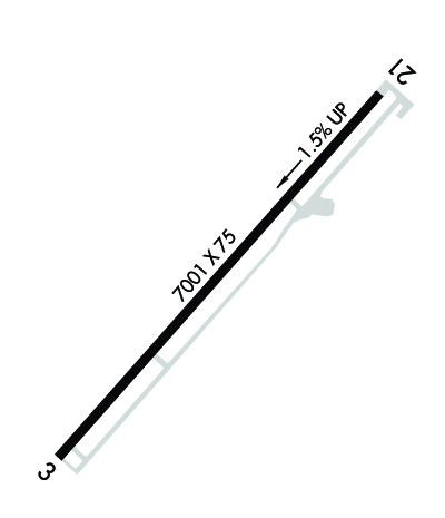
| Rwy | Rwy | |||||||
| 7001x75 | 7001' | 7001x75 | 7001' | |||||
| Runway ID | Single Wheel | Double Wheel | Double Tandem Wheel | Dual Double Wheel |
| 03/21 | N/A | N/A | N/A | N/A |
| These numbers are Advisory and are not limits. The Airport Manager should have more accurate Weight Limits | ||||
 Airport Diagram might not be current. | |
| Facility Name: | TAYLOR |
| City Name: | TAYLOR |
| County: | NAVAJO |
| State abbrev: | AZ |
| State Name: | ARIZONA |
| Ownership: | PUBLICLY OWNED |
| Use: | OPEN TO THE PUBLIC |
| Owner's Name: | TOWN OF TAYLOR |
| Address: | BOX 158 |
| TAYLOR, AZ 85939 | |
| Owner's Phone: | 520-536-7366 |
| Manager's Name: | RAY WEBBER; ALTERNATE CONTACT: GUS LUNDBERG 928-536-7366. |
| Address: | BOX 158 |
| TAYLOR, AZ 85939 | |
| Phone: | 928-606-9779 |
| FAA Region: | WESTERN-PACIFIC |
| FAA Field Office: | PHX |
| Date | Sunrise | Sunset |
|---|---|---|
| 04/17/24 Wednesday | 5:46 | 18:55 |
| 04/18/24 Thursday | 5:44 | 18:55 |
| 04/19/24 Friday | 5:43 | 18:56 |
| 04/20/24 Saturday | 5:42 | 18:57 |
| 04/21/24 Sunday | 5:41 | 18:58 |
| 04/22/24 Monday | 5:40 | 18:59 |
| 04/23/24 Tuesday | 5:38 | 18:59 |
| 04/24/24 Wednesday | 5:37 | 19:00 |
| 04/25/24 Thursday | 5:36 | 19:01 |
| 04/26/24 Friday | 5:35 | 19:02 |
| 04/27/24 Saturday | 5:34 | 19:03 |
| 04/28/24 Sunday | 5:33 | 19:03 |
| 04/29/24 Monday | 5:32 | 19:04 |
| 04/30/24 Tuesday | 5:31 | 19:05 |
| Airport Attendance Schedule | MON-FRI 0730-1700 |
| Airport Status | OPERATIONAL (This Status can change at any time - please check NOTAMS) |
| Airport Lighting Schedule | ACTVT REIL RWY 03 & 21; PAPI RWY 03 & 21; MIRL RWY 03/21 - CTAF. |
| Airport Storage Available | Tie Downs |
| Extra Services Available | Flight Instruction, Aircraft Rental |
| Wind Indicator | YES - (lighted) |
| Control Tower | NO |
| CTAF Frequency | 122.700 |
| Unicom Frequency | 122.700 |
| Rotating Beacon Color | WG |
| Segmented Circle | YES |
| Landing Fee | NO |
| Airport Inspected | STATE - performed by PRIVATE CONTRACT PERSONNEL |
| Inspection Date | 04/09/2021 |
| Type of Fuel Available | Grade 100LL; -10SELF SERVICE FUEL AVAILABLE 24 HRS. WITH MAJOR CREDIT CARD. |
| Airframe Repair Service | MAJOR |
| Power Plant Repair Service | MAJOR |
| Latitude | N3427.2 |
| Longitude | W11006.9 (ESTIMATED) |
| Arpt Elevation | 5823ft (SURVEYED) |
| Magnetic Variation | 09E |
| 2 miles SW | of TAYLOR |
| Traffic Pattern Altitude | |
| Sectional Chart | PHOENIX |
| Operations (Reported) | Yearly | Avg. Daily |
|---|---|---|
| General Aviation Transient | 1000 | 3 |
| General Aviation Local | 2100 | 6 |
| Air Taxi | 30 | 0 |
| Commerical | 0 | 0 |
| Commuter | 0 | 0 |
| Military | 0 | 0 |
| Aircraft based on Field | |
|---|---|
| General Aviation Singles | 15 |
| General Aviation Multi | 0 |
| Jet Aircraft | 0 |
| General Aviation Helicopters | 0 |
| Military Aircraft | 0 |
| Gliders | 0 |
| Ultralights | 0 |
| FSS on field | NO |
| FSS tie-in | PRESCOTT |
| FSS Phone | 1-800-WX-BRIEF |
| Who issues Notams | PRC |
| Notam D service at airport | YES |
| ARTCC Name | ALBUQUERQUE |
| Airport Certification | |
| Aircraft Rescue & Firefighting Index | None |
| Airport of Entry | No |
| Custom Landing Rights | No |
| Joint Civil/Military | No |
| Military Landing rights | No |
| NATIONAL PLAN OF INTEGRATED AIRPORT SYSTEMS (NPIAS) |
| GRANT AGREEMENTS UNDER FAAP/ADAP/AIP |
| ASSURANCES PURSUANT TO TITLE VI, CIVIL RIGHTS ACT OF 1964 |
| FOR FBO CTC 928-606-9779. |
| 4-9 FT TREES AND BRUSH IN PRIMARY SURFACE NW SIDE OF RWY, 100-250 FT FM CNTRLN. |
| WILDLIFE ON OR INVOF ARPT. |
| SEVERAL RWY HOLD AND EXIT SIGNS OUT OF SERVICE INDEF. |
| FOR CD CTC ALBUQUERQUE ARTCC AT 505-856-4861. |
Airport Communications & Frequencies:
| |||||||||
| Runway: 03 | Runway: 21 | ||
| Mag heading: | 33° | Mag heading: | 213° |
| Rwy Slope: | -1.48% Down | Rwy Slope: | 1.48% Up |
| Approach: | Approach: | ||
| Pattern: | Left Traffic | Pattern: | Left Traffic |
| Markings: | BASIC | Markings: | NONPRECISION INSTRUMENT |
| Marking Condition: | GOOD | Marking Condition: | GOOD |
| Arresting Dev: | Arresting Dev: | ||
| Lat & Long: | N3426.7 W11007.4 | Lat. & Long.: | N3427.6 W11006.4 |
| Elev: | 5823.1 ft. MSL | Elev: | 5719.6 ft. MSL |
| TCH: | 49 ft. AGL | TCH: | 43 ft. AGL |
| Visual Glide Path: | 4.00 degrees | Visual Glide Path: | 3.00 degrees |
| Displaced Threshold: | No | Displaced Threshold: | No |
| Touchdown Zone: | YES | Touchdown Zone: | YES |
| Touchdown Elev.: | 5823.1 feet | Touchdown Elev.: | 5758.2 feet |
| Visual Glide Slope: | 2-Light PAPI on LEFT side of Runway | Visual Glide Slope: | 2-Light PAPI on LEFT side of Runway |
| RVR Equipment: | RVR Equipment: | ||
| RVV Equipment: | NO | RVV Equipment: | NO |
| Approach Lights: | Approach Lights: | ||
| REIL: | YES | REIL: | YES |
| Centerline Lights: | NO | Centerline Lights: | NO |
| Touchdown lights: | NO | Touchdown lights: | NO |
| Runway Category: | Runway with a Visual Approach | Runway Category: | Runway with a Non-precision Approach having visibility minimums greater than 3/4 mile |
| Declared Distances: | Declared Distances: |
